METAR & TAF 21D
Current METAR
Observed 20:35Z
K21D 272035Z AUTO 33010G18KT 10SM CLR 35/17 A2971 RMK AO2
- Wind
- 330° @ 10G18 kt
- Visibility
- 10 SM
- Temp / Dew
- 35°C / 17°C
- Altimeter
- 29.71 inHg
- Clouds
- CLR
- Density alt
- 3,817 ft
- Ceiling
- Unlimited
- Rules
- VFR
Airport info & contacts
Manager on record, flight service, ARTCC, attendance schedule and pattern altitude — published by the FAA and refreshed every 28 days.
Location
- From city
- 9 NM E
- VFR sectional
- GREEN BAY
- ARTCC
- ZMP · MINNEAPOLIS
- NOTAM facility
- 21D (NOTAM-D)
Airport manager
- Name
- PHILIP TIEDEMAN
- Phone
- 763-717-0001
- Address
- 6040 28TH AVE S, MINNEAPOLIS MN 55450-2799
Flight service · Hours
- FSS PNM
- PRINCETON1-800-WX-BRIEF
- Attendance
- APR-OCT · 0700-1900
- NOV-MAR · 0700-1700
Frequencies
Tap any row to copy the frequency to your clipboard.
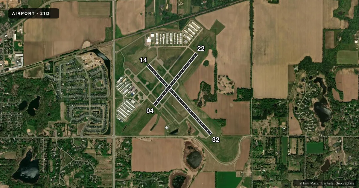
Runways & pattern
Full pagePattern entry · RWY 32
LEFT TRAFFIC| Runway | Heading (°M) | Length | Surface | Traffic |
|---|---|---|---|---|
| 14/32Favored | 137° / 317° | 3,504 ft | ASPH | Standard L |
| 04/22 | 38° / 218° | 2,496 ft | ASPH | Standard L |
Runway end performance
| End | TORA | TODA | ASDA | LDA | VGSI | Approach lights | Obstruction |
|---|---|---|---|---|---|---|---|
| 14 | — | — | — | — | PAPI 4-box left(3.5°) | — | — |
| 32 | — | — | — | — | PAPI 4-box left(3.5°) | — | — |
Declared distances in feet. TORA = takeoff run available, TODA = takeoff distance, ASDA = accelerate-stop, LDA = landing distance.
Airport sketch
Runways drawn to scale from FAA survey coordinates, rendered over satellite imagery. Not for navigation.
Approaches & charts
Services on the field
Fuel grades, oxygen, maintenance, ramp storage and lighting — as declared to the FAA by the airport operator.
Fuel & services
- Fuel
- 100LLA
- Oxygen (bottled)
- Not available
- Oxygen (bulk)
- Not available
- Airframe repair
- Major
- Power plant repair
- Major
- Other services
- INSTR,RNTL,SALES
Ramp & ground
- Transient storage
- Tie-down
- Hangar
- Landing fee
- No fee published
- Customs
- Not available
- Lighting schedule
- SEE RMK
- Beacon schedule
- SS-SR
- Beacon
- White / Green (civil land)(WG)
- Wind indicator
- Lighted
- Segmented circle
- No
Fuel & FBOs
Cheapest 100LL and Jet A on the field and nearby. Always confirm with the FBO before taxi.
Airport notes
Surface conditions, obstructions, local procedures, lighting outages and other notes published with each FAA cycle.
General notes
- ULTRALIGHT OPS PROHIBITED.
- VOLUNTARY NOISE ABATEMENT PROCS IN EFCT. SEE ARPT WEBSITE FOR MORE INFO.
- DEER, BIRDS, & WILDLIFE ON & INVOF ARPT.
- FOR CD CTC MINNEAPOLIS APCH AT 612-713-4016.
Lighting notes
- ACTVT OR INCR INTST REIL RWY 14 & 32; PAPI RWY 14 & 32; MIRL RWY 14/32 - CTAF. MIRL RWY 14/32 PRESET LOW INTST.
Fuel notes
- 100LLFUEL AVBL H24 SELF SVC VIA CREDIT CARD.
Approach & departure obstructions
- 32CALM WND RWY.
Other notes
- ADNL LGTD WIND-T.
VFR map & nearby airports
VFR sectional. Tap any ICAO chip to open that airport.
Key facts · 21D
Answer card- ICAO
- 21D
- Name
- LAKE ELMO
- Location
- ST PAUL, MINNESOTA
- Elevation
- 932.9 ft MSL
- Traffic pattern altitude
- 1,932.9 ft MSL (1,000 AGL)
- Control tower
- Non-towered (use CTAF)
- Total runways
- 2
- Longest runway
- 14/32 · 3,504 ft
- Published ILS approaches
- 0
- Published frequencies
- 5
- Magnetic variation
- 1°
- Current flight rules
- VFR
- Current wind
- 330° at 10 kt
- Favored runway now
- RWY 32
Lake Elmo (21D) sits in St Paul, Minnesota. Field elevation is 932.9 ft MSL. The airport has two asphalt runways. The longest is 14/32 at 3,504 ft. Runway 04/22 is 2,496 ft. There is no control tower. CTAF and UNICOM are both 123.075. No ILS approaches are published here.
Pattern altitude is not published. Use the standard 1,000 ft AGL for light piston operations unless the current Chart Supplement says otherwise. That puts the pattern around 1,933 ft MSL based on the field elevation. Lake Elmo Aero is on the field. It carries 100LL. Fuel is available 24 hours a day self-service by credit card.
A few operational notes matter here. Voluntary noise abatement procedures are in effect. Deer, birds and other wildlife are reported on and near the airport. Ultralight operations are prohibited. Runway 14/32 has PAPI, REIL and medium intensity lights. The runway lights are controlled by CTAF. Minneapolis Approach handles clearance delivery and approach or departure services. For a first visit, brief the calm wind runway. Expect a non-towered pattern with local noise awareness.