METAR & TAF 1M7
1M7 does not publish a METAR.
Showing the nearest reporting station: KUCY (EVERETT-STEWART RGNL) · 9.4 NM away. Conditions at 1M7 may differ.
METAR · KUCY
Observed 20:30Z
KUCY 112030Z AUTO 21010G15KT 10SM CLR 33/23 A2986 RMK A01
- Wind
- 210° @ 10G15 kt
- Visibility
- 10 SM
- Temp / Dew
- 33°C / 23°C
- Altimeter
- 29.86 inHg
- Clouds
- CLR
- Density alt
- 2,735 ft
- Ceiling
- Unlimited
- Rules
- VFR
Airport info & contacts
Manager on record, flight service, ARTCC, attendance schedule and pattern altitude — published by the FAA and refreshed every 28 days.
Location
- From city
- 2 NM NW
- VFR sectional
- ST LOUIS
- ARTCC
- ZME · MEMPHIS
- NOTAM facility
- LOU (NOTAM-D)
Airport manager
- Name
- DAVID WHITE
- Phone
- 731-796-0786
- Address
- 306 RT 1641, FULTON KY 42041
Flight service · Hours
- FSS LOU
- LOUISVILLE1-800-WX-BRIEF
- Attendance
- Unattended
Frequencies
Tap any row to copy the frequency to your clipboard.
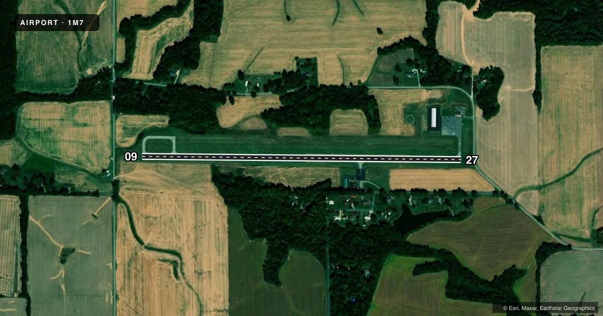
Runways & pattern
Full pagePattern entry · RWY 27
LEFT TRAFFICRunway end performance
| End | TORA | TODA | ASDA | LDA | VGSI | Approach lights | Obstruction |
|---|---|---|---|---|---|---|---|
| 09 | 4,001' | 4,001' | 3,841' | 3,841' | PAPI 2-box left(3°) | — | — |
| 27 | 4,001' | 4,001' | 4,001' | 3,841' | PAPI 2-box left(3°) | — | 15', road, 320' from thr, 0' R of cntrln, slope 8 |
Declared distances in feet. TORA = takeoff run available, TODA = takeoff distance, ASDA = accelerate-stop, LDA = landing distance.
Airport sketch
Runways drawn to scale from FAA survey coordinates, rendered over satellite imagery. Not for navigation.
Approaches & charts
Services on the field
Fuel grades, oxygen, maintenance, ramp storage and lighting — as declared to the FAA by the airport operator.
Fuel & services
- Fuel
- 100LL
- Oxygen (bottled)
- Not available
- Oxygen (bulk)
- Not available
- Airframe repair
- Minor
- Power plant repair
- Minor
- Other services
- INSTR
Ramp & ground
- Transient storage
- Tie-down
- Hangar
- Landing fee
- No fee published
- Customs
- Not available
- Lighting schedule
- SEE RMK
- Beacon schedule
- SS-SR
- Beacon
- White / Green (civil land)(WG)
- Wind indicator
- Lighted
- Segmented circle
- Yes
Fuel & FBOs
Cheapest 100LL and Jet A on the field and nearby. Always confirm with the FBO before taxi.
Airport notes
Surface conditions, obstructions, local procedures, lighting outages and other notes published with each FAA cycle.
General notes
- FOR CD CTC MEMPHIS ARTCC AT 901-368-8453/8449.
Lighting notes
- ACTVT REIL RWY 09 & 27; PAPI RWY 09 & 27; HIRL RWY 09/27 - CTAF.
Approach & departure obstructions
- 27APCH RATIO 14:1 TO DTHR.
Other notes
- OWNERBARRY SHARP
VFR map & nearby airports
VFR sectional. Tap any ICAO chip to open that airport.
Key facts · 1M7
Answer card- ICAO
- 1M7
- Name
- FULTON
- Location
- FULTON, KENTUCKY
- Elevation
- 403.6 ft MSL
- Traffic pattern altitude
- 1,403.6 ft MSL (1,000 AGL)
- Control tower
- Non-towered (use CTAF)
- Total runways
- 1
- Longest runway
- 09/27 · 4,001 ft
- Published ILS approaches
- 0
- Published frequencies
- 2
- Magnetic variation
- 3°
- Current flight rules
- VFR
- Current wind
- 210° at 10 kt
- Favored runway now
- RWY 27
Fulton Airport sits in Fulton, Kentucky. Field elevation is 403.6 ft MSL. It has one runway. Runway 09/27 is 4,001 ft of asphalt, so it works best for light piston traffic and other aircraft that fit the length and surface. The airport is non-towered. CTAF and UNICOM are both 122.7. No ILS approaches are published here.
Pattern altitude is not published. Use the standard 1,000 ft AGL pattern unless the current FAA Chart Supplement or local traffic calls for something different. The on-field FBO is Fulton Airport. It carries AVGAS 100LL. Call (270) 621-1134 before you go if you need current service details.
A few operational notes matter here. Runway end identifier lights are active on 09 and 27. PAPI is installed on both runway ends. High intensity runway lights are installed on 09/27 and are controlled by CTAF. The published remarks also note a displaced threshold issue on runway 27 with a 14 to 1 approach ratio to that threshold. If you are planning a first arrival, brief the lighting and the runway 27 threshold picture before descent. For clearance delivery, Memphis ARTCC can be reached at 901-368-8453 or 901-368-8449.