METAR & TAF 12V
12V does not publish a METAR.
Showing the nearest reporting station: KHTS (TRI-STATE/MILTON J FERGUSON FLD) · 17.5 NM away. Conditions at 12V may differ.
METAR · KHTS
Observed 03:51Z
KHTS 120351Z 00000KT 10SM CLR 26/22 A2991 RMK AO2 SLP117 T02560222
- Wind
- 000° @ 0 kt
- Visibility
- 10 SM
- Temp / Dew
- 26°C / 22°C
- Altimeter
- 29.91 inHg
- Clouds
- CLR
- Density alt
- 2,041 ft
- Ceiling
- Unlimited
- Rules
- VFR
Airport info & contacts
Manager on record, flight service, ARTCC, attendance schedule and pattern altitude — published by the FAA and refreshed every 28 days.
Location
- From city
- 4 NM W
- VFR sectional
- CINCINNATI
- ARTCC
- ZID · INDIANAPOLIS
- NOTAM facility
- EKN (NOTAM-D)
Airport manager
- Name
- BILL & LYNN BAUER
- Phone
- 954-328-7646
- Address
- # 1 FAIR SKIES DR., ONA WV 25545-1500
Flight service · Hours
- FSS EKN
- ELKINS703-724-42881-800-WX-BRIEF
- Attendance
- ALL
Frequencies
Tap any row to copy the frequency to your clipboard.
Runways & pattern
Full pagePattern entry · RWY 07
LEFT TRAFFICRunway end performance
| End | TORA | TODA | ASDA | LDA | VGSI | Approach lights | Obstruction |
|---|---|---|---|---|---|---|---|
| 07 | — | — | — | — | — | — | 4', fence, 201' from thr, 1122' R of cntrln, slope 0 |
| 25 | — | — | — | — | — | — | 40', trees, 201' from thr, 60' R of cntrln, slope 0 |
Declared distances in feet. TORA = takeoff run available, TODA = takeoff distance, ASDA = accelerate-stop, LDA = landing distance.
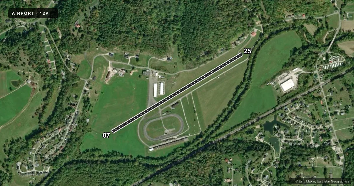
Airport sketch
Runways drawn to scale from FAA survey coordinates, rendered over satellite imagery. Not for navigation.
Approaches & charts
Services on the field
Fuel grades, oxygen, maintenance, ramp storage and lighting — as declared to the FAA by the airport operator.
Fuel & services
- Fuel
- 100LL
- Airframe repair
- Major
- Power plant repair
- Major
- Other services
- CHTR,INSTR,RNTL
Ramp & ground
- Transient storage
- Tie-down
- Hangar
- Landing fee
- No fee published
- Lighting schedule
- SS-SR
- Wind indicator
- Yes
- Segmented circle
- No
Fuel & FBOs
Cheapest 100LL and Jet A on the field and nearby. Always confirm with the FBO before taxi.
Airport notes
Surface conditions, obstructions, local procedures, lighting outages and other notes published with each FAA cycle.
General notes
- NOISE ABATEMENT PROCEDURES IN EFFECT; DEP RWY 25 FLY 240 DEGS & DEP RWY 07 FLY 090 DEGS TO 1600 FT ALTITUDE.
- RWY EXIT TO RAMP HAS DEPRESSION.
- (A52-09) +350 HILL 1300 FT DSTC.
- FENCE, POLES, BLDGS, IN PRIMARY SFC, WEST SIDE.
- RACE TRACK ADJACENT TO RWY 07/25.
- VEHICLES CROSSING RWY.
- FOR CD CTC HUNTINGTON ATCT AT 304-453-2490.
Fuel notes
- 100LL24 HR SELF-SERVE.
Runway surface & condition
- 07/25NSTD LIRL LIGHTS, NSTD SPACING AND COLORS.
Approach & departure obstructions
- 2520 FT HILL, 200 FT FM RWY END, 172 FT RIGHT, 40 FT TREES, 200 DSTC, 60-247 FT L.
- 07ALSO 75 FT TREE, 615 FT DSTC, 28 FT L, OBSTN CLNC SLOPE 5:1.
Other notes
- THIS AIRPORT HAS BEEN SURVEYED BY THE NATIONAL GEODETIC SURVEY.
VFR map & nearby airports
VFR sectional. Tap any ICAO chip to open that airport.
Key facts · 12V
Answer card- ICAO
- 12V
- Name
- ONA AIRPARK
- Location
- MILTON, WEST VIRGINIA
- Elevation
- 571.7 ft MSL
- Traffic pattern altitude
- 1,571.7 ft MSL (1,000 AGL)
- Control tower
- Non-towered (use CTAF)
- Total runways
- 1
- Longest runway
- 07/25 · 3,154 ft
- Published ILS approaches
- 0
- Published frequencies
- 6
- Magnetic variation
- 6°
- Current flight rules
- VFR
- Current wind
- 000° at 0 kt
- Favored runway now
- –
Ona Airpark sits in Milton, West Virginia. Field elevation is 571.7 ft MSL. The airport has one asphalt runway. Runway 07/25 is 3,154 ft long, which is the longest runway on the field. There is no control tower. The field uses CTAF 122.8 and UNICOM 122.8. No ILS approaches are published.
Pattern altitude is not published. Use 1,000 ft AGL for light piston operations unless current local guidance says otherwise. The on-field FBO is Ona Airpark. It carries 100LL. Self-serve 100LL is available 24 hours. If you need clearance delivery, the published remark points pilots to Huntington Air Traffic Control Tower at 304-453-2490.
This is a field where local awareness matters. Published remarks note a race track next to runway 07/25. Vehicles also cross the runway. There are fences, poles and buildings on the west side of the primary surface. A hill rises about 350 ft above ground level at 1,300 ft distant. Noise abatement is published. Departures off runway 25 should fly 240 degrees to 1,600 ft. Departures off runway 07 should fly 090 degrees to 1,600 ft. Runway lighting is nonstandard low intensity with nonstandard spacing and colors. Check the current FAA Chart Supplement before you go. That is the best source for any updates on local procedures.