METAR & TAF 01G
01G does not publish a METAR.
Showing the nearest reporting station: KDSV (DANSVILLE MUNI) · 18.1 NM away. Conditions at 01G may differ.
METAR · KDSV
Observed 08:54Z
KDSV 120854Z AUTO 14005KT 10SM CLR 20/19 A2977 RMK AO2 SLP084 T02000194 55006
- Wind
- 140° @ 5 kt
- Visibility
- 10 SM
- Temp / Dew
- 20°C / 19°C
- Altimeter
- 29.77 inHg
- Clouds
- CLR
- Density alt
- 2,718 ft
- Ceiling
- Unlimited
- Rules
- VFR
Airport info & contacts
Manager on record, flight service, ARTCC, attendance schedule and pattern altitude — published by the FAA and refreshed every 28 days.
Location
- From city
- 3 NM NW
- VFR sectional
- DETROIT
- ARTCC
- ZOB · CLEVELAND
- NOTAM facility
- BUF (NOTAM-D)
Airport manager
- Name
- KEN MOSES
- Phone
- 585-237-9938
- Address
- 6522 RT. 20A, PERRY NY 14530
Flight service · Hours
- FSS BUF
- BUFFALO1-800-WX-BRIEF
- Attendance
- MON-FRI · IREG
Frequencies
Tap any row to copy the frequency to your clipboard.
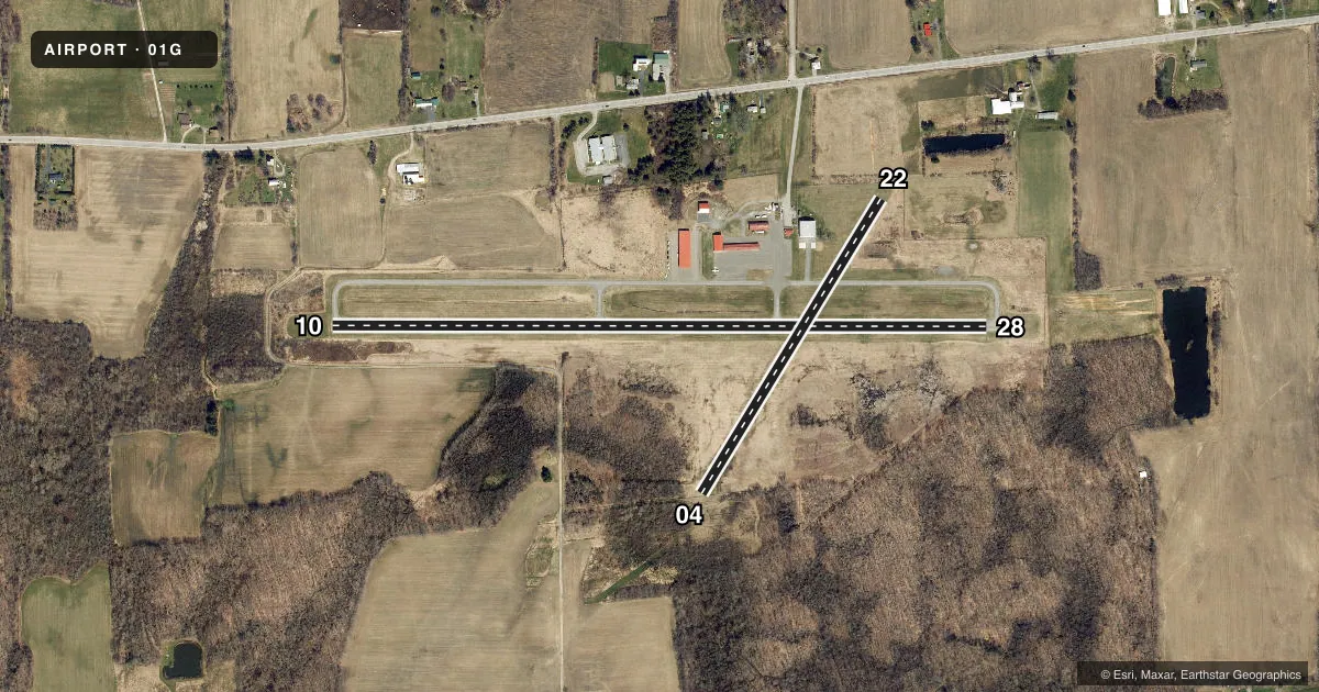
Runways & pattern
Full pagePattern entry · RWY 10
LEFT TRAFFIC| Runway | Heading (°M) | Length | Surface | Traffic |
|---|---|---|---|---|
| 10/28Favored | 80° / 260° | 3,429 ft | ASPH | Standard L |
| 04/22 | 21° / 201° | 1,806 ft | TURF | Standard L |
Runway end performance
| End | TORA | TODA | ASDA | LDA | VGSI | Approach lights | Obstruction |
|---|---|---|---|---|---|---|---|
| 10 | — | — | — | — | — | — | 35', tree, 201' from thr, 75' R of cntrln, slope 0 |
| 28 | — | — | — | — | — | — | 50', trees, 302' from thr, 135' R of cntrln, slope 2 |
| 04 | — | — | — | — | — | — | 40', trees, 18' from thr, 101' R of cntrln, slope 0 |
| 22 | — | — | — | — | — | — | 6', fence, 0' from thr, 123' R of cntrln, slope 0 |
Declared distances in feet. TORA = takeoff run available, TODA = takeoff distance, ASDA = accelerate-stop, LDA = landing distance.
Airport sketch
Runways drawn to scale from FAA survey coordinates, rendered over satellite imagery. Not for navigation.
Approaches & charts
Services on the field
Fuel grades, oxygen, maintenance, ramp storage and lighting — as declared to the FAA by the airport operator.
Fuel & services
- Fuel
- 100LL
- Oxygen (bottled)
- Not available
- Oxygen (bulk)
- Not available
- Airframe repair
- Major
- Power plant repair
- Major
Ramp & ground
- Transient storage
- Tie-down
- Landing fee
- No fee published
- Customs
- Not available
- Lighting schedule
- SEE RMK
- Beacon schedule
- SS-SR
- Beacon
- White / Green (civil land)(WG)
- Wind indicator
- Lighted
- Segmented circle
- No
Fuel & FBOs
Cheapest 100LL and Jet A on the field and nearby. Always confirm with the FBO before taxi.
Airport notes
Surface conditions, obstructions, local procedures, lighting outages and other notes published with each FAA cycle.
General notes
- TURF RWY 04/22 MAY BE UNUSBL OCT-MAY.
- 8 FT DROPOFF BOTH SIDES, 200 FT DSTC.
- PARALLEL TWY UNLGTD.
- RWY 28: FIRST 700 FT SLOPES UPHILL.
- RWY 4 SAFETY AREA DROPS OFF 100 FT BEFORE RWY BEG, 125 FT L & R OF CNTRLN.
- FIRST 1,700 FT OF RY 10 SLOPES UPHILL.
- FOR CD CTC CLEVELAND ARTCC AT 440-774-0490.
Lighting notes
- ACTVT REIL RWY 10 & 28; MIRL RWY 10/28 - CTAF.
Fuel notes
- 100LL24 HRS SELF SVC.
Approach & departure obstructions
- 1020 FT TREES; UP TO 200 FT DSTC, 8 FT LEFT & RIGHT.
- 2825:1 APCH SLOPE AT DTHR.
Other notes
- EXISTED PRIOR TO 1959.
- OWNERBECKY RYAN & JIM BRICK, CO-SUPERVISORS
- MANAGERAMGR CELL 585-353-4666.
- 04/22RWY 4/22 UNEVEN. RWY & TWY XNGS RUF. RWY SOFT & WET MAR-JUN. CALL FOR FICONS.
VFR map & nearby airports
VFR sectional. Tap any ICAO chip to open that airport.
Key facts · 01G
Answer card- ICAO
- 01G
- Name
- PERRY-WARSAW
- Location
- PERRY, NEW YORK
- Elevation
- 1,558.1 ft MSL
- Traffic pattern altitude
- 2,558.1 ft MSL (1,000 AGL)
- Control tower
- Non-towered (use CTAF)
- Total runways
- 2
- Longest runway
- 10/28 · 3,429 ft
- Published ILS approaches
- 0
- Published frequencies
- 2
- Magnetic variation
- 10°
- Current flight rules
- VFR
- Current wind
- 140° at 5 kt
- Favored runway now
- RWY 10
Perry-Warsaw Airport sits in Perry, New York. The field elevation is 1,558.1 ft MSL. It has two runways. The longest is 10/28 at 3,429 ft on asphalt. The shorter runway is 04/22 at 1,806 ft on turf. There is no control tower. CTAF and UNICOM are both 122.8. No ILS approaches are published here.
Pattern altitude is not published. Use the standard 1,000 ft AGL unless local procedures or the current Chart Supplement say otherwise. The airport is served by Perry-Warsaw Airport on the field. It carries 100LL. Self-serve 100LL is available 24 hours. That helps if you are planning an early arrival or a late departure.
Read the remarks before you go. Runway 04/22 is reported uneven. It can be soft and wet from March through June. The turf runway may be unusable from October through May. Runway 10 has trees close in near the approach end. Runway 28 has a displaced threshold with a steep approach slope. The parallel taxiway is unlighted. Runway end identifier lights are on 10 and 28. Medium intensity runway lights on 10 and 28 are CTAF controlled. This is a non-towered field with a 1,558 ft elevation. Performance and density altitude deserve a quick check before you launch.