METAR & TAF 7G0
7G0 does not publish a METAR.
Showing the nearest reporting station: KROC (FREDERICK DOUGLASS/GREATER ROCHESTER INTL) · 11.3 NM away. Conditions at 7G0 may differ.
METAR · KROC
Observed 00:54Z
KROC 120054Z 23005KT 10SM FEW015 FEW080 SCT130 BKN250 24/22 A2973 RMK AO2 SLP062 T02440217 $
- Wind
- 230° @ 5 kt
- Visibility
- 10 SM
- Temp / Dew
- 24°C / 22°C
- Altimeter
- 29.73 inHg
- Clouds
- BKN
- Density alt
- 2,140 ft
- Ceiling
- 25,000 ft AGL
- Rules
- VFR
Airport info & contacts
Manager on record, flight service, ARTCC, attendance schedule and pattern altitude — published by the FAA and refreshed every 28 days.
Location
- From city
- 3 NM SE
- VFR sectional
- DETROIT
- ARTCC
- ZOB · CLEVELAND
- NOTAM facility
- BUF (NOTAM-D)
Airport manager
- Name
- CODY JOHNSON
- Phone
- 585-880-3298
- Address
- 21 EISENHAUER DR, BROCKPORT NY 14420
Flight service · Hours
- FSS BUF
- BUFFALO1-800-WX-BRIEF
- Attendance
- 1000-1600
Frequencies
Tap any row to copy the frequency to your clipboard.
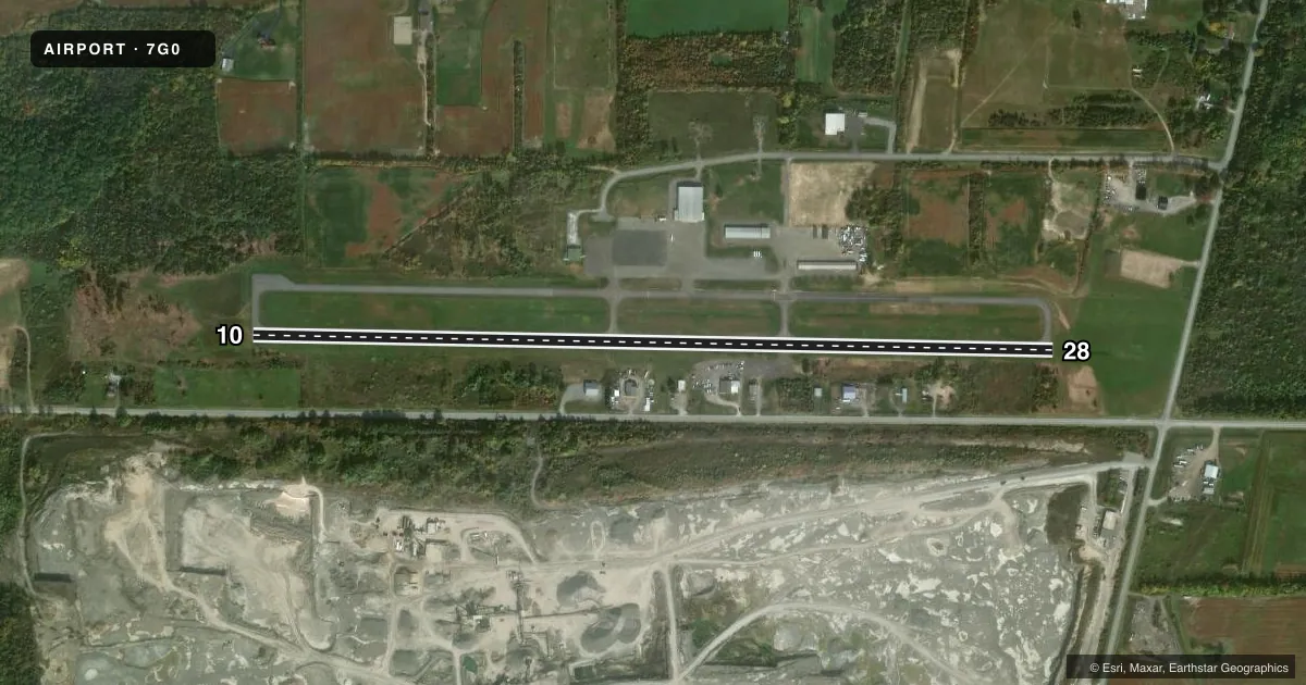
Runways & pattern
Full pagePattern entry · RWY 28
LEFT TRAFFICRunway end performance
| End | TORA | TODA | ASDA | LDA | VGSI | Approach lights | Obstruction |
|---|---|---|---|---|---|---|---|
| 10 | — | — | — | — | — | — | 15', trees, 201' from thr, 166' R of cntrln, slope 0 |
| 28 | — | — | — | — | — | — | 15', trees, 201' from thr, 212' R of cntrln, slope 0 |
Declared distances in feet. TORA = takeoff run available, TODA = takeoff distance, ASDA = accelerate-stop, LDA = landing distance.
Airport sketch
Runways drawn to scale from FAA survey coordinates, rendered over satellite imagery. Not for navigation.
Approaches & charts
Services on the field
Fuel grades, oxygen, maintenance, ramp storage and lighting — as declared to the FAA by the airport operator.
Fuel & services
- Fuel
- 100LLA
- Oxygen (bottled)
- Not available
- Oxygen (bulk)
- Not available
- Airframe repair
- Major
- Power plant repair
- Major
- Other services
- INSTR
Ramp & ground
- Transient storage
- Tie-down
- Hangar
- Landing fee
- No fee published
- Beacon schedule
- SS-SR
- Beacon
- White / Green (civil land)(WG)
- Wind indicator
- Lighted
- Segmented circle
- No
Fuel & FBOs
Cheapest 100LL and Jet A on the field and nearby. Always confirm with the FBO before taxi.
Airport notes
Surface conditions, obstructions, local procedures, lighting outages and other notes published with each FAA cycle.
General notes
- BIRDS SPRING & FALL & DEER INVOF ARPT.
- FOR CD CTC CLEVELAND ARTCC AT 440-774-0490.
Approach & departure obstructions
- 1012 FT BRUSH 199 FT FM RWY END 166 FT R.
- 2815 FT TREES 160 FT L.
- 10FADED.
- 28FADED.
- 10CNTLG OBSTN EXCEEDS 45 DEG SLP.
Other notes
- 1AFT HR - 585-880-3290.
VFR map & nearby airports
VFR sectional. Tap any ICAO chip to open that airport.
Key facts · 7G0
Answer card- ICAO
- 7G0
- Name
- LEDGEDALE AIRPARK
- Location
- BROCKPORT, NEW YORK
- Elevation
- 664.9 ft MSL
- Traffic pattern altitude
- 1,664.9 ft MSL (1,000 AGL)
- Control tower
- Non-towered (use CTAF)
- Total runways
- 1
- Longest runway
- 10/28 · 4,206 ft
- Published ILS approaches
- 0
- Published frequencies
- 4
- Magnetic variation
- 11°
- Current flight rules
- VFR
- Current wind
- 230° at 5 kt
- Favored runway now
- RWY 28
Ledgedale Airpark sits in Brockport, New York. Field elevation is 664.9 ft MSL. The airport has one runway. Runway 10/28 is 4,206 ft of asphalt, which is the longest runway on the field. There is no control tower. CTAF and UNICOM are both 122.7. Approach and departure service is on 123.7 and 322.3 through Rochester. No ILS approaches are published.
The pattern altitude is not published. Use standard 1,000 ft AGL for light piston operations unless the current Chart Supplement says otherwise. The on-field FBO is Ledgedale Air Park. It carries 100LL and Jet A Prist. Call (585) 233-5117 for current service details before you go.
A few runway notes matter here. Runway 10 has a controlling obstruction that exceeds the 45 degree slope. There is also 12 ft brush 199 ft from the runway end and 166 ft right of runway 10. Runway 28 has 15 ft trees 160 ft left of the runway end. Markings on both runway ends are faded. Birds are present in spring and fall. Deer are also in the vicinity. For clearance delivery, contact Cleveland ARTCC at 440-774-0490. After hours, call 585-880-3290. If you are planning a night or first-time arrival, review the current Chart Supplement and brief the runway environment before you launch.