METAR & TAF M78
M78 does not publish a METAR.
Showing the nearest reporting station: KHOT (MEML FLD) · 18.7 NM away. Conditions at M78 may differ.
METAR · KHOT
Observed 18:53Z
KHOT 111853Z AUTO 19008KT 10SM FEW035 BKN047 31/22 A2989 RMK AO2 SLP114 T03110222 $
- Wind
- 190° @ 8 kt
- Visibility
- 10 SM
- Temp / Dew
- 31°C / 22°C
- Altimeter
- 29.89 inHg
- Clouds
- BKN
- Density alt
- 2,624 ft
- Ceiling
- 4,700 ft AGL
- Rules
- VFR
Airport info & contacts
Manager on record, flight service, ARTCC, attendance schedule and pattern altitude — published by the FAA and refreshed every 28 days.
Location
- From city
- 3 NM SE
- VFR sectional
- MEMPHIS
- ARTCC
- ZME · MEMPHIS
- NOTAM facility
- JBR (NOTAM-D)
Airport manager
- Name
- JOHN NEELY
- Phone
- 501-337-9939
- Address
- 115 AIRPORT ROAD, MALVERN AR 72104
Flight service · Hours
- FSS JBR
- JONESBORO1-800-WX-BRIEF
- Attendance
- MON-FRI · 0730-1630
Frequencies
Tap any row to copy the frequency to your clipboard.
Runways & pattern
Full pagePattern entry · RWY 22
LEFT TRAFFICRunway end performance
| End | TORA | TODA | ASDA | LDA | VGSI | Approach lights | Obstruction |
|---|---|---|---|---|---|---|---|
| 22 | — | — | — | — | — | — | 41', trees, 725' from thr, 325' R of cntrln, slope 12 |
Declared distances in feet. TORA = takeoff run available, TODA = takeoff distance, ASDA = accelerate-stop, LDA = landing distance.
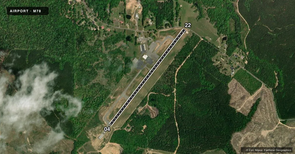
Airport sketch
Runways drawn to scale from FAA survey coordinates, rendered over satellite imagery. Not for navigation.
Approaches & charts
Services on the field
Fuel grades, oxygen, maintenance, ramp storage and lighting — as declared to the FAA by the airport operator.
Fuel & services
- Fuel
- 100LL
- Airframe repair
- Major
- Power plant repair
- Major
Ramp & ground
- Transient storage
- Tie-down
- Hangar
- Landing fee
- No fee published
- Customs
- Not available
- Lighting schedule
- SEE RMK
- Beacon schedule
- SS-SR
- Beacon
- White / Green (civil land)(WG)
- Wind indicator
- Lighted
- Segmented circle
- Yes
Fuel & FBOs
Cheapest 100LL and Jet A on the field and nearby. Always confirm with the FBO before taxi.
Airport notes
Surface conditions, obstructions, local procedures, lighting outages and other notes published with each FAA cycle.
General notes
- FOR CD CTC LITTLE ROCK APCH 501-379-2908 OR LITTLE ROCK ATCT 501-379-2911.
Lighting notes
- ACTVT MIRL RWY 04/22 - CTAF.
Fuel notes
- 100LLFOR SVC AFT HRS CALL 501-315-9004.
Approach & departure obstructions
- 22ROAD & 4 FT FENCE 28 FT FM THLD.
- 22APCH RATIO 25:1 FM DSPLCD THLD.
Other notes
- THIS AIRPORT HAS BEEN SURVEYED BY THE NATIONAL GEODETIC SURVEY.
VFR map & nearby airports
VFR sectional. Tap any ICAO chip to open that airport.
Key facts · M78
Answer card- ICAO
- M78
- Name
- MALVERN MUNI
- Location
- MALVERN, ARKANSAS
- Elevation
- 538 ft MSL
- Traffic pattern altitude
- 1,538 ft MSL (1,000 AGL)
- Control tower
- Non-towered (use CTAF)
- Total runways
- 1
- Longest runway
- 04/22 · 3,188 ft
- Published ILS approaches
- 0
- Published frequencies
- 2
- Magnetic variation
- 0°
- Current flight rules
- VFR
- Current wind
- 190° at 8 kt
- Favored runway now
- RWY 22
Malvern Muni sits in Malvern, Arkansas. Field elevation is 538 ft MSL. The airport has one runway, 04/22, which is 3,188 ft long. There is no control tower. CTAF and UNICOM are both 122.8. No ILS approaches are published here.
Pattern altitude is not published. Use the standard 1,000 ft AGL pattern for light piston traffic unless the current Chart Supplement says otherwise. That puts the traffic pattern at 1,538 ft MSL based on the field elevation. Runway 04/22 has medium intensity lighting that is activated on CTAF. The runway 22 end has a road and a 4-foot fence 28 ft from the threshold. The published approach ratio from the displaced threshold is 25 to 1, so plan your arrival with that in mind.
N2 Aviation Works is on the field. It carries AVGAS 100LL. For after-hours fuel service, the published remark gives a phone number to call. Clearance delivery is handled through Little Rock Approach or Little Rock Air Traffic Control Tower, so verify current procedures before departure. This is a non-towered field with a single asphalt runway, so keep your scan tight and expect local traffic to be working the CTAF.