METAR & TAF KCDH
Current METAR
Observed 16:35Z
KCDH 271635Z AUTO 30009KT 10SM CLR 33/23 A2996 RMK AO2 T03330231 $
- Wind
- 300° @ 9 kt
- Visibility
- 10 SM
- Temp / Dew
- 33°C / 23°C
- Altimeter
- 29.96 inHg
- Clouds
- CLR
- Density alt
- 2,271 ft
- Ceiling
- Unlimited
- Rules
- VFR
Airport info & contacts
Manager on record, flight service, ARTCC, attendance schedule and pattern altitude — published by the FAA and refreshed every 28 days.
Location
- From city
- 5 NM NE
- VFR sectional
- MEMPHIS
- ARTCC
- ZFW · FORT WORTH
- NOTAM facility
- JBR (NOTAM-D)
Airport manager
- Name
- KYLE GATLING
- Phone
- 870-818-3408
- Address
- 255 AIRPORT RD, CAMDEN AR 71701
Flight service · Hours
- FSS JBR
- JONESBORO1-800-WX-BRIEF
- Attendance
- MON-FRI · 0800-1630
Frequencies
Tap any row to copy the frequency to your clipboard.
Runways & pattern
Full pagePattern entry · RWY 01
LEFT TRAFFICRunway end performance
| End | TORA | TODA | ASDA | LDA | VGSI | Approach lights | Obstruction |
|---|---|---|---|---|---|---|---|
| 01 | — | — | — | — | PAPI 2-box left(3°) | — | 45', trees, 1050' from thr, 360' R of cntrln, slope 18 |
| 19 | — | — | — | — | PAPI 2-box left(3°) | — | 55', trees, 600' from thr, 250' R of cntrln, slope 7 |
Declared distances in feet. TORA = takeoff run available, TODA = takeoff distance, ASDA = accelerate-stop, LDA = landing distance.
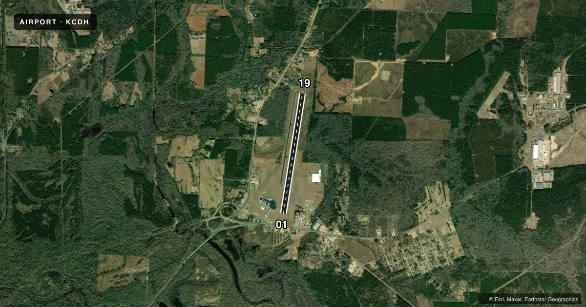
Airport sketch
Runways drawn to scale from FAA survey coordinates, rendered over satellite imagery. Not for navigation.
Approaches & charts
Services on the field
Fuel grades, oxygen, maintenance, ramp storage and lighting — as declared to the FAA by the airport operator.
Fuel & services
- Fuel
- 100LLA
- Oxygen (bottled)
- Not available
- Airframe repair
- Not available
- Power plant repair
- Not available
Ramp & ground
- Transient storage
- Tie-down
- Hangar
- Landing fee
- No fee published
- Customs
- Not available
- Lighting schedule
- SEE RMK
- Beacon schedule
- SS-SR
- Beacon
- White / Green (civil land)(WG)
- Wind indicator
- Lighted
- Segmented circle
- Yes
Fuel & FBOs
Cheapest 100LL and Jet A on the field and nearby. Always confirm with the FBO before taxi.
Airport notes
Surface conditions, obstructions, local procedures, lighting outages and other notes published with each FAA cycle.
General notes
- FOR CD CTC FORT WORTH ARTCC AT 817-858-7584.
Lighting notes
- ACTVT REIL RWY 01 & 19; PAPI RWY 01 & 19; MIRL RWY 01/19 - CTAF.
Fuel notes
- 100LLFUEL AVBL SELF SERVE 24 HRS WITH CREDIT CARD (100LL & JET A).
Approach & departure obstructions
- 01UNUSBL BYD 5.0 DEGS LEFT AND RIGHT OF CNTRLN.
- 19UNUSBL BYD 4.0 DEGS RIGHT OF CNTRLN.
Other notes
- THIS AIRPORT HAS BEEN SURVEYED BY THE NATIONAL GEODETIC SURVEY.
- 1FOR SVC AFT HRS CALL 870-818-3408.
VFR map & nearby airports
VFR sectional. Tap any ICAO chip to open that airport.
Key facts · KCDH
Answer card- ICAO
- KCDH
- Name
- HARRELL FLD
- Location
- CAMDEN, ARKANSAS
- Elevation
- 129.6 ft MSL
- Traffic pattern altitude
- 1,129.6 ft MSL (1,000 AGL)
- Control tower
- Non-towered (use CTAF)
- Total runways
- 1
- Longest runway
- 01/19 · 6,502 ft
- Published ILS approaches
- 0
- Published frequencies
- 2
- Magnetic variation
- 2°
- Current flight rules
- VFR
- Current wind
- 300° at 9 kt
- Favored runway now
- RWY 01
Harrell Fld sits in Camden, Arkansas. Field elevation is 129.6 ft MSL. The airport has one runway, 01/19, which is 6,502 ft long. There is no control tower. CTAF and UNICOM are both 122.7. No ILS approaches are published here.
Pattern altitude is not published. Use the standard 1,000 ft AGL pattern unless local procedures or the current Chart Supplement say otherwise. The on-field FBO is Harrell Field. It carries 100LL and Jet A Prist. Self-serve fuel is available 24 hours with a credit card. After-hours service is handled by phone at (870) 818-3408.
A few runway notes matter here. Runway 01 is unusable beyond 5.0 degrees left and right of centerline. Runway 19 is unusable beyond 4.0 degrees right of centerline. Runway end identifier lights are active on both ends. PAPI is installed on 01 and 19. Medium intensity runway lights are on runway 01/19 and are controlled by CTAF. For clearance delivery, contact Fort Worth ARTCC at 817-858-7584. If you are planning a first stop here, brief the non-towered flow. Brief the lighting control. Brief the runway alignment limits before arrival.