METAR & TAF M75
Current METAR
Observed 15:15Z
KM75 271515Z AUTO 00000KT 7SM CLR 21/13 A2993 RMK A01
- Wind
- 000° @ 0 kt
- Visibility
- 7 SM
- Temp / Dew
- 21°C / 13°C
- Altimeter
- 29.93 inHg
- Clouds
- CLR
- Density alt
- 3,502 ft
- Ceiling
- Unlimited
- Rules
- VFR
Airport info & contacts
Manager on record, flight service, ARTCC, attendance schedule and pattern altitude — published by the FAA and refreshed every 28 days.
Location
- From city
- 1 NM NW
- VFR sectional
- BILLINGS
- ARTCC
- ZLC · SALT LAKE CITY
- NOTAM facility
- GTF (NOTAM-D)
Airport manager
- Name
- DIXON HITCH
- Phone
- 406-654-1143
- Address
- BOX 1242, MALTA MT 59538
Flight service · Hours
- FSS GTF
- GREAT FALLS1-800-WX-BRIEF
- Attendance
- ALL
Frequencies
Tap any row to copy the frequency to your clipboard.
Runways & pattern
Full pagePattern entry · RWY 08
LEFT TRAFFICRunway end performance
| End | TORA | TODA | ASDA | LDA | VGSI | Approach lights | Obstruction |
|---|---|---|---|---|---|---|---|
| 08 | — | — | — | — | PAPI 2-box left(3°) | — | — |
| 26 | — | — | — | — | PAPI 2-box left(3°) | — | — |
Declared distances in feet. TORA = takeoff run available, TODA = takeoff distance, ASDA = accelerate-stop, LDA = landing distance.
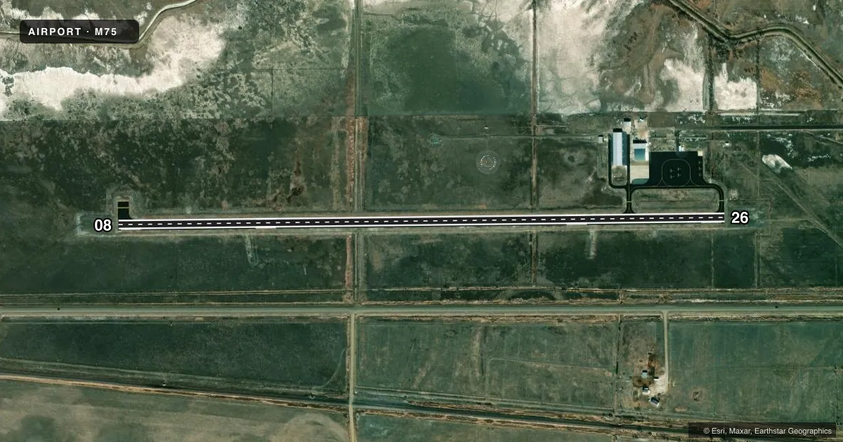
Airport sketch
Runways drawn to scale from FAA survey coordinates, rendered over satellite imagery. Not for navigation.
Approaches & charts
Services on the field
Fuel grades, oxygen, maintenance, ramp storage and lighting — as declared to the FAA by the airport operator.
Fuel & services
- Fuel
- 100LLA+
- Oxygen (bottled)
- Not available
- Oxygen (bulk)
- Not available
- Airframe repair
- Not available
- Power plant repair
- Not available
- Other services
- AGRI
Ramp & ground
- Transient storage
- Tie-down
- Hangar
- Landing fee
- No fee published
- Lighting schedule
- SEE RMK
- Beacon schedule
- SEE RMK
- Beacon
- White / Green (civil land)(WG)
- Wind indicator
- Lighted
- Segmented circle
- Yes
Fuel & FBOs
Cheapest 100LL and Jet A on the field and nearby. Always confirm with the FBO before taxi.
Airport notes
Surface conditions, obstructions, local procedures, lighting outages and other notes published with each FAA cycle.
General notes
- FOR CD CTC SALT LAKE ARTCC AT 801-320-2568.
Lighting notes
- ACTVT ROTG BCN-CTAF.
- MIRL RWY 08/26 & PAPI RWYS 08 & 26 OPR DUSK-2200, AFTER 2200 ACTVT - CTAF.
Other notes
- THIS AIRPORT HAS BEEN SURVEYED BY THE NATIONAL GEODETIC SURVEY.
- AUTOMATED UNICOM.
- MANAGEROR 406-390-0114 (CELL)
VFR map & nearby airports
VFR sectional. Tap any ICAO chip to open that airport.
Key facts · M75
Answer card- ICAO
- M75
- Name
- MALTA
- Location
- MALTA, MONTANA
- Elevation
- 2,253.8 ft MSL
- Traffic pattern altitude
- 3,253.8 ft MSL (1,000 AGL)
- Control tower
- Non-towered (use CTAF)
- Total runways
- 1
- Longest runway
- 08/26 · 4,500 ft
- Published ILS approaches
- 0
- Published frequencies
- 2
- Magnetic variation
- 12°
- Current flight rules
- VFR
- Current wind
- 000° at 0 kt
- Favored runway now
- –
Malta Airport (M75) sits in Malta, Montana. The field elevation is 2,253.8 ft MSL. It has one runway, 08/26, which is 4,500 ft long and paved. There is no control tower. CTAF and UNICOM are both 122.8. No ILS approaches are published, so plan with the current chart and weather in mind.
The published pattern altitude is not listed. Use the current FAA Chart Supplement for the published value before flight. If no local procedure is published, standard light piston pattern practice is 1,000 ft AGL. The airport has medium intensity runway lights on 08/26. The PAPI on both ends operates from dusk to 2200. After 2200, lighting is activated via CTAF. The rotating beacon is also activated via CTAF. Automated UNICOM is available.
Hitch Aviation is on the field. It carries AVGAS 100LL and Jet A. If you need clearance delivery, contact Salt Lake ARTCC at 801-320-2568. For a first-time arrival, expect a non-towered field at higher elevation with one runway and no published ILS. Check density altitude, especially on warm days. The airport is in a rural part of Montana, so plan your arrival, fuel needs and lighting use before you get close.