METAR & TAF M41
M41 does not publish a METAR.
Showing the nearest reporting station: KOLV (OLIVE BRANCH/TAYLOR FLD) · 16.8 NM away. Conditions at M41 may differ.
METAR · KOLV
Observed 18:50Z
KOLV 241850Z 16004G10KT 10SM OVC029 28/20 A3007
- Wind
- 160° @ 4G10 kt
- Visibility
- 10 SM
- Temp / Dew
- 28°C / 20°C
- Altimeter
- 30.07 inHg
- Clouds
- OVC
- Density alt
- 2,058 ft
- Ceiling
- 2,900 ft AGL
- Rules
- MVFR
Airport info & contacts
Manager on record, flight service, ARTCC, attendance schedule and pattern altitude — published by the FAA and refreshed every 28 days.
Location
- From city
- 4 NM W
- VFR sectional
- MEMPHIS
- ARTCC
- ZME · MEMPHIS
- NOTAM facility
- GWO (NOTAM-D)
Airport manager
- Name
- ROD CHILDERS
- Phone
- 901-230-3421
- Address
- 520 J M ASH DR, PO BOX 128, HOLLY SPRINGS MS 38635
Flight service · Hours
- FSS GWO
- GREENWOOD1-800-WX-BRIEF
- Attendance
- MON-FRI · 0800-1700
Frequencies
Tap any row to copy the frequency to your clipboard.
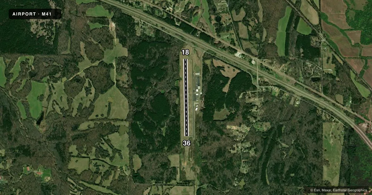
Runways & pattern
Full pagePattern entry · RWY 18
LEFT TRAFFICRunway end performance
| End | TORA | TODA | ASDA | LDA | VGSI | Approach lights | Obstruction |
|---|---|---|---|---|---|---|---|
| 18 | — | — | — | — | PAPI 2-box left(2.75°) | — | — |
| 36 | — | — | — | — | PAPI 2-box left(3.25°) | — | — |
Declared distances in feet. TORA = takeoff run available, TODA = takeoff distance, ASDA = accelerate-stop, LDA = landing distance.
Airport sketch
Runways drawn to scale from FAA survey coordinates, rendered over satellite imagery. Not for navigation.
Approaches & charts
Services on the field
Fuel grades, oxygen, maintenance, ramp storage and lighting — as declared to the FAA by the airport operator.
Fuel & services
- Fuel
- 100LLA
- Oxygen (bottled)
- Not available
- Oxygen (bulk)
- Not available
- Airframe repair
- Major
- Power plant repair
- Major
- Other services
- INSTR
Ramp & ground
- Transient storage
- Tie-down
- Landing fee
- No fee published
- Customs
- Not available
- Lighting schedule
- SS-SR
- Beacon schedule
- SS-SR
- Beacon
- White / Green (civil land)(WG)
- Wind indicator
- Lighted
- Segmented circle
- Yes
Fuel & FBOs
Cheapest 100LL and Jet A on the field and nearby. Always confirm with the FBO before taxi.
Airport notes
Surface conditions, obstructions, local procedures, lighting outages and other notes published with each FAA cycle.
General notes
- FOR CD CTC MEMPHIS ARTCC AT 901-368-8453/8449.
Fuel notes
- 100LLFUEL SVC AVBL 24 HRS WITH CREDIT CARD.
Other notes
- PILOTS PRVD THEIR OWN TIE DOWNS.
- OWNERAND MARSHALL COUNTY.
VFR map & nearby airports
VFR sectional. Tap any ICAO chip to open that airport.
Key facts · M41
Answer card- ICAO
- M41
- Name
- HOLLY SPRINGS-MARSHALL COUNTY
- Location
- HOLLY SPRINGS, MISSISSIPPI
- Elevation
- 551.3 ft MSL
- Traffic pattern altitude
- 1,551.3 ft MSL (1,000 AGL)
- Control tower
- Non-towered (use CTAF)
- Total runways
- 1
- Longest runway
- 18/36 · 3,202 ft
- Published ILS approaches
- 0
- Published frequencies
- 7
- Magnetic variation
- 2°
- Current flight rules
- MVFR
- Current wind
- 160° at 4 kt
- Favored runway now
- RWY 18
M41 sits in Holly Springs, Mississippi. Field elevation is 551.3 ft MSL. The airport has one runway. Runway 18/36 is 3,202 ft long with an asphalt surface. That is the longest runway on the field.
There is no control tower. CTAF and UNICOM are both 122.8. Memphis provides the approach and departure frequencies. No ILS approaches are published here, so plan with the current charted procedures and verify the latest setup before you go. Pattern altitude is not published. Use the standard 1,000 ft AGL pattern unless the current Chart Supplement says otherwise.
Marshall County Airport is the on-field FBO. It carries 100LL and Jet A. Fuel service is available 24 hours with credit card. Pilots provide their own tie downs, so plan for that on arrival. For clearance delivery, contact Memphis ARTCC before departure.
This is a non-towered field with a single short runway by transport standards. Watch your performance numbers, especially on hot days. The field sits in north Mississippi, so local weather and soft-field planning can matter. Check the current Chart Supplement for any published noise or curfew restrictions before flying into the field.