METAR & TAF KTZV
KTZV does not publish a METAR.
Showing the nearest reporting station: KGLW (GLASGOW MUNI) · 23.2 NM away. Conditions at KTZV may differ.
METAR · KGLW
Observed 05:15Z
KGLW 120515Z AUTO 21005KT 10SM CLR 26/21 A2995 RMK AO2 T02570207
- Wind
- 210° @ 5 kt
- Visibility
- 10 SM
- Temp / Dew
- 26°C / 21°C
- Altimeter
- 29.95 inHg
- Clouds
- CLR
- Density alt
- 2,568 ft
- Ceiling
- Unlimited
- Rules
- VFR
Airport info & contacts
Manager on record, flight service, ARTCC, attendance schedule and pattern altitude — published by the FAA and refreshed every 28 days.
Location
- From city
- 2 NM NE
- VFR sectional
- ST LOUIS
- ARTCC
- ZME · MEMPHIS
- NOTAM facility
- LOU (NOTAM-D)
Airport manager
- Name
- KANEIA COPASS
- Phone
- 270-646-0544
- Address
- PO BOX 175, TOMPKINSVILLE KY 42167
Flight service · Hours
- FSS LOU
- LOUISVILLE1-800-WX-BRIEF
- Attendance
- Unattended
Frequencies
Tap any row to copy the frequency to your clipboard.
Runways & pattern
Full pagePattern entry · RWY 22
LEFT TRAFFICRunway end performance
| End | TORA | TODA | ASDA | LDA | VGSI | Approach lights | Obstruction |
|---|---|---|---|---|---|---|---|
| 04 | — | — | — | — | PAPI 2-box left(3.75°) | — | — |
| 22 | — | — | — | — | PAPI 2-box left(3°) | — | — |
Declared distances in feet. TORA = takeoff run available, TODA = takeoff distance, ASDA = accelerate-stop, LDA = landing distance.
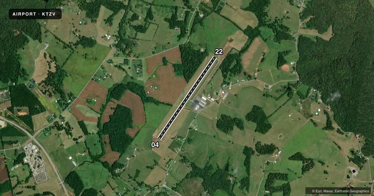
Airport sketch
Runways drawn to scale from FAA survey coordinates, rendered over satellite imagery. Not for navigation.
Approaches & charts
Services on the field
Fuel grades, oxygen, maintenance, ramp storage and lighting — as declared to the FAA by the airport operator.
Fuel & services
- Fuel
- 100LL
- Airframe repair
- Major
- Power plant repair
- Major
Ramp & ground
- Transient storage
- Tie-down
- Hangar
- Landing fee
- No fee published
- Lighting schedule
- SEE RMK
- Beacon schedule
- SS-SR
- Beacon
- White / Green (civil land)(WG)
- Wind indicator
- Lighted
- Segmented circle
- Yes
Fuel & FBOs
Cheapest 100LL and Jet A on the field and nearby. Always confirm with the FBO before taxi.
Airport notes
Surface conditions, obstructions, local procedures, lighting outages and other notes published with each FAA cycle.
General notes
- USE CTAF FOR TRML ACES.
- FOR CD CTC MEMPHIS ARTCC AT 901-368-8453/8449.
Lighting notes
- ACTVT REIL RWY 04 & 22; PAPI RWY 04 & 22; MIRL RWY 04/22 - CTAF.
Approach & departure obstructions
- 04ALGAE COVERED.
- 22ALGAE COVERED.
Other notes
- VFR USE ONLY.
- 1AFT HRS CALL 270-646-0544.
- MANAGER214-458-0600
VFR map & nearby airports
VFR sectional. Tap any ICAO chip to open that airport.
Key facts · KTZV
Answer card- ICAO
- KTZV
- Name
- TOMPKINSVILLE/MONROE COUNTY
- Location
- TOMPKINSVILLE, KENTUCKY
- Elevation
- 1,036.2 ft MSL
- Traffic pattern altitude
- 2,036.2 ft MSL (1,000 AGL)
- Control tower
- Non-towered (use CTAF)
- Total runways
- 1
- Longest runway
- 04/22 · 4,000 ft
- Published ILS approaches
- 0
- Published frequencies
- 2
- Magnetic variation
- 4°
- Current flight rules
- VFR
- Current wind
- 210° at 5 kt
- Favored runway now
- RWY 22
Tompkinsville/Monroe County Airport (KTZV) sits in Tompkinsville, Kentucky. Field elevation is 1,036.2 ft MSL. The airport has one runway. Runway 04/22 is 4,000 ft long with an asphalt surface. It is a non-towered field. CTAF and UNICOM are both 123.05. No ILS approaches are published here.
The published pattern altitude is not listed. Use the standard 1,000 ft AGL pattern for light piston traffic unless the current Chart Supplement says otherwise. The field is marked VFR only. That matters if you are planning an IFR arrival. For clearance delivery, contact Memphis ARTCC using the published phone numbers before departure.
Tompkinsville-Monroe County Airport is the on-field FBO. It carries 100LL. After hours contact is published in the remarks. The runway lighting setup includes REILs and PAPI on both ends. Medium intensity runway lights are available on 04/22 and are controlled by CTAF. The remarks also note algae on both runway ends, so expect a surface condition check on rollout and during preflight planning. Use the current Chart Supplement and a local call if you need the latest operational details before you go.