METAR & TAF KTAN
Current METAR
Observed 02:52Z
KTAN 120252Z AUTO 00000KT 10SM CLR 22/21 A2969 RMK AO2 SLP054 T02220211 50008 $
- Wind
- 000° @ 0 kt
- Visibility
- 10 SM
- Temp / Dew
- 22°C / 21°C
- Altimeter
- 29.69 inHg
- Clouds
- CLR
- Density alt
- 1,176 ft
- Ceiling
- Unlimited
- Rules
- VFR
Airport info & contacts
Manager on record, flight service, ARTCC, attendance schedule and pattern altitude — published by the FAA and refreshed every 28 days.
Location
- From city
- 3 NM E
- VFR sectional
- NEW YORK
- ARTCC
- ZBW · BOSTON
- NOTAM facility
- TAN (NOTAM-D)
Airport manager
- Name
- JAY D' ESPINOSA
- Phone
- 508-821-2973
- Address
- 4 WESTCOAT, EAST TAUNTON MA 02718
Flight service · Hours
- FSS BDR
- BRIDGEPORT1-800-WX-BRIEF
- Attendance
- 0600 - 1400
Frequencies
Tap any row to copy the frequency to your clipboard.
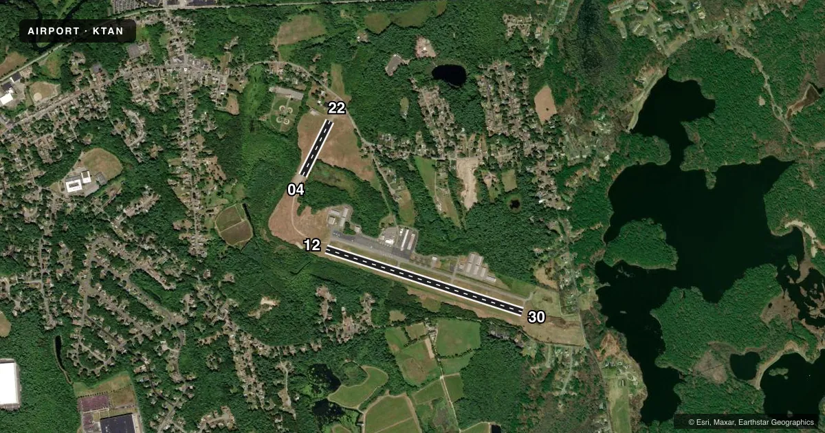
Runways & pattern
Full pagePattern entry · RWY 12
LEFT TRAFFIC| Runway | Heading (°M) | Length | Surface | Traffic |
|---|---|---|---|---|
| 12/30 | 92° / 272° | 3,499 ft | ASPH | Standard L |
| 04/22 | 11° / 191° | 1,034 ft | TURF-GRVL | Standard L |
Runway end performance
| End | TORA | TODA | ASDA | LDA | VGSI | Approach lights | Obstruction |
|---|---|---|---|---|---|---|---|
| 12 | — | — | — | — | — | — | 23', trees, 1000' from thr, 135' R of cntrln, slope 34 |
| 30 | — | — | — | — | PAPI 4-box right(4°) | — | 40', trees, 1075' from thr, 125' R of cntrln, slope 20 |
| 04 | — | — | — | — | — | — | 60', trees, 800' from thr, 125' R of cntrln, slope 12 |
| 22 | — | — | — | — | — | — | 85', trees, 1000' from thr, 125' R of cntrln, slope 12 |
Declared distances in feet. TORA = takeoff run available, TODA = takeoff distance, ASDA = accelerate-stop, LDA = landing distance.
Airport sketch
Runways drawn to scale from FAA survey coordinates, rendered over satellite imagery. Not for navigation.
Approaches & charts
Services on the field
Fuel grades, oxygen, maintenance, ramp storage and lighting — as declared to the FAA by the airport operator.
Fuel & services
- Fuel
- 100LL
- Oxygen (bottled)
- Not available
- Oxygen (bulk)
- Not available
- Airframe repair
- Major
- Power plant repair
- Major
- Other services
- INSTR
Ramp & ground
- Transient storage
- Tie-down
- Landing fee
- No fee published
- Customs
- Not available
- Lighting schedule
- SEE RMK
- Beacon schedule
- SS-SR
- Beacon
- White / Green (civil land)(WG)
- Wind indicator
- Lighted
- Segmented circle
- Yes
Fuel & FBOs
Cheapest 100LL and Jet A on the field and nearby. Always confirm with the FBO before taxi.
Airport notes
Surface conditions, obstructions, local procedures, lighting outages and other notes published with each FAA cycle.
General notes
- AVOID FLYING OVR THE ELEMENTARY SCHOOL AT DER 30.
- HEL AVOID OVERFLIGHT OF DENSELY POPULATED AREAS W & S OF ARPT.
- CAUTION WILDLIFE, DEER & GEESE ON AND INVOF ARPT AND RWYS.
- FOR CD CTC PROVIDENCE APCH AT 401-738-8945, WHEN APCH CLSD CTC BOSTON ARTCC AT 603-879-6859.
Lighting notes
- ACTVT PAPI RWY 30; MIRL RWY 12/30; LGTD WINDSOCK - CTAF.
Runway surface & condition
- 12/30PCR VALUE: 150/F/B/X/T
Other notes
- ESTAB PRIOR TO 1959.
- 04/22SFC ROUGH & LOOSE STONES.
VFR map & nearby airports
VFR sectional. Tap any ICAO chip to open that airport.
Key facts · KTAN
Answer card- ICAO
- KTAN
- Name
- TAUNTON MUNI/KING FLD
- Location
- TAUNTON, MASSACHUSETTS
- Elevation
- 41.3 ft MSL
- Traffic pattern altitude
- 1,041.3 ft MSL (1,000 AGL)
- Control tower
- Non-towered (use CTAF)
- Total runways
- 2
- Longest runway
- 12/30 · 3,499 ft
- Published ILS approaches
- 0
- Published frequencies
- 4
- Magnetic variation
- 16°
- Current flight rules
- VFR
- Current wind
- 000° at 0 kt
- Favored runway now
- –
Taunton Muni/King Fld sits in Taunton, Massachusetts. Field elevation is 41.3 ft MSL. The airport has two runways. The longest is 12/30 at 3,499 ft. Runway 04/22 is 1,034 ft turf-gravel, so check surface condition before you plan to use it. There is no control tower. CTAF and UNICOM are both 122.7. No ILS approaches are published here.
Pattern altitude is not published. Use the standard 1,000 ft AGL for light piston traffic unless the current Chart Supplement says otherwise. The on-field FBO is Taunton Municipal Airport. It carries AVGAS 100LL. Call (508) 821-2973 for current service details.
A few local items matter here. Avoid flying over the elementary school at the departure end of runway 30. Runway 04/22 is reported rough with loose stones. Wildlife is a real factor too. Expect deer and geese near the airport and on the runways. Runway 12/30 has medium intensity lights. PAPI is available for runway 30. For clearance delivery, contact Providence Approach. When Approach is closed, use Boston ARTCC. Helicopters should avoid densely populated areas west and south of the airport.