METAR & TAF KSFZ
Current METAR
Observed 02:56Z
KSFZ 120256Z AUTO 26004KT 10SM CLR 25/23 A2973 RMK AO2 SLP063 T02500228 50006 $
- Wind
- 260° @ 4 kt
- Visibility
- 10 SM
- Temp / Dew
- 25°C / 23°C
- Altimeter
- 29.73 inHg
- Clouds
- CLR
- Density alt
- 1,982 ft
- Ceiling
- Unlimited
- Rules
- VFR
Airport info & contacts
Manager on record, flight service, ARTCC, attendance schedule and pattern altitude — published by the FAA and refreshed every 28 days.
Location
- From city
- 3 NM E
- VFR sectional
- NEW YORK
- ARTCC
- ZBW · BOSTON
- NOTAM facility
- SFZ (NOTAM-D)
Airport manager
- Name
- IFTIKHAR AHMAD
- Phone
- 401-691-2000
- Address
- RHODE ISLAND AIRPORT CORP, 2000 POST RD, WARWICK RI 02886
Flight service · Hours
- FSS BDR
- BRIDGEPORT1-800-WX-BRIEF
- Attendance
- SUN-SAT · 0700-1700
Frequencies
Tap any row to copy the frequency to your clipboard.
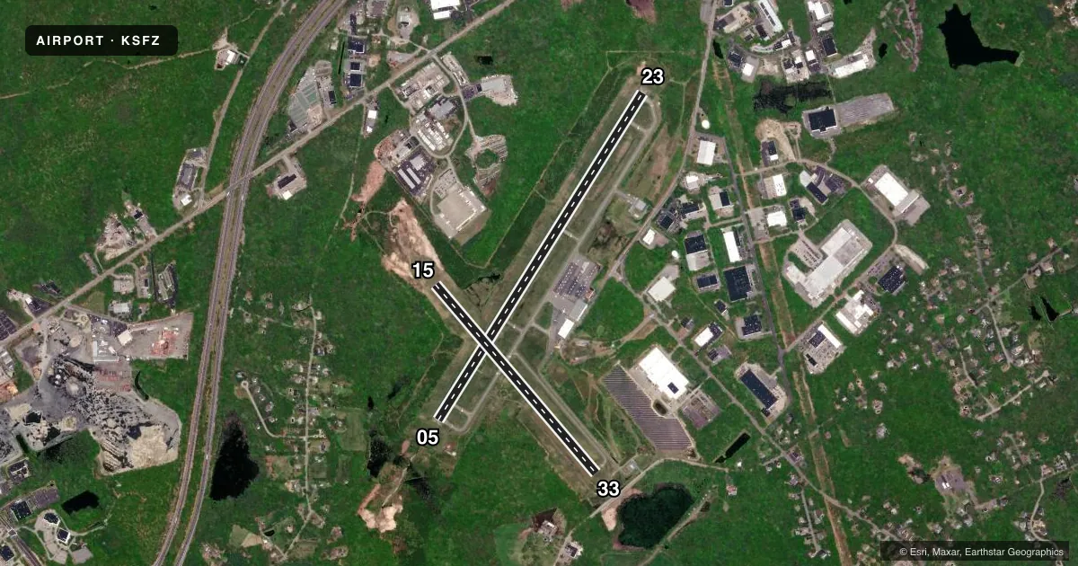
Runways & pattern
Full pagePattern entry · RWY 23
LEFT TRAFFIC| Runway | Heading (°M) | Length | Surface | Traffic |
|---|---|---|---|---|
| 05/23Favored | 17° / 197° | 5,000 ft | ASPH | Standard L |
| 15/33 | 125° / 305° | 3,211 ft | ASPH | Standard L |
Runway end performance
| End | TORA | TODA | ASDA | LDA | VGSI | Approach lights | Obstruction |
|---|---|---|---|---|---|---|---|
| 05 | — | — | — | — | PAPI 4-box right(3°) | MALS | 53', trees, 2200' from thr, 700' R of cntrln, slope 37 |
| 23 | — | — | — | — | PAPI 4-box left(3°) | — | 20', trees, 900' from thr, 150' R of cntrln, slope 35 |
| 15 | — | — | — | — | PAPI 4-box left(3.5°) | — | 39', trees, 850' from thr, 200' R of cntrln, slope 16 |
| 33 | — | — | — | — | — | — | 24', trees, 535' from thr, 90' R of cntrln, slope 13 |
Declared distances in feet. TORA = takeoff run available, TODA = takeoff distance, ASDA = accelerate-stop, LDA = landing distance.
Airport sketch
Runways drawn to scale from FAA survey coordinates, rendered over satellite imagery. Not for navigation.
Approaches & charts
ILS · 1
Services on the field
Fuel grades, oxygen, maintenance, ramp storage and lighting — as declared to the FAA by the airport operator.
Fuel & services
- Fuel
- 100LLAA+
- Oxygen (bottled)
- Not available
- Oxygen (bulk)
- Not available
- Airframe repair
- Major
- Power plant repair
- Major
- Other services
- CHTR,GLD,INSTR,PAJA,RNTL,SALES
Ramp & ground
- Transient storage
- Tie-down
- Hangar
- Landing fee
- Yes
- Customs
- Not available
- Lighting schedule
- SEE RMK
- Beacon schedule
- SS-SR
- Beacon
- White / Green (civil land)(WG)
- Wind indicator
- Lighted
- Segmented circle
- Yes
Fuel & FBOs
Cheapest 100LL and Jet A on the field and nearby. Always confirm with the FBO before taxi.
Airport notes
Surface conditions, obstructions, local procedures, lighting outages and other notes published with each FAA cycle.
General notes
- LGTD 250 FT MSL TWR 3-2/5 MI SE.
- OVNGT PRKG FEE.
- +50 FT DROPOFF 250 FT FM RWY 05 END, +40 FT DROPOFF 250 FT FM RWY 23 END.
- SEASONAL SKYDIVING NE SIDE OF AIRFIELD.
- NOISE ABATEMENT PROCS IN EFCT, CTC AMGR.
- RWY CONDS MAY NOT BE MNT OR RPRTD WHEN AP IS UNATNDD. CTC RI AP CORPORATION OPS AT 401-691-2265.
- FOR CD WHEN APCH CLSD CTC BOSTON ARTCC AT 603-879-6859.
- AP WILDLIFE HAZ DEER ACT INCREASED HN.
- NMRS UNLGTD OBSTNS UP TO 150 FT AGL SRNDG AIRFIELD.
- BIRDS & WILDLIFE ON & INVOF ARPT.
Lighting notes
- ACTVT MALS RWY 05; REIL RWY 23, 15 & 33; PAPI RWY 05, 15 & 23; HIRL RWY 05/23; MIRL RWY 15/33; TWY LGTS - CTAF.
Approach & departure obstructions
- 05+10 FT TREES 150 FT FM THR, 180 FT L; +10 FT TREES 120 FT FM THR, 180 FT R.
- 23+15 FT TREES 170 FT FM THR, 90 FT R; +10 FT TREES 120 FT FM THR, 150 FT L.
Other notes
- EXISTED PRIOR TO 1959.
- LDG FEE FOR COML ACFT & NON-RHODE ISLAND REGISTERED ACFT.
VFR map & nearby airports
VFR sectional. Tap any ICAO chip to open that airport.
Key facts · KSFZ
Answer card- ICAO
- KSFZ
- Name
- NORTH CENTRAL STATE
- Location
- PAWTUCKET, RHODE ISLAND
- Elevation
- 440.5 ft MSL
- Traffic pattern altitude
- 1,440.5 ft MSL (1,000 AGL)
- Control tower
- Non-towered (use CTAF)
- Total runways
- 2
- Longest runway
- 05/23 · 5,000 ft
- Published ILS approaches
- 1
- Published frequencies
- 5
- Magnetic variation
- 15°
- Current flight rules
- VFR
- Current wind
- 260° at 4 kt
- Favored runway now
- RWY 23
North Central State Airport is in Pawtucket, Rhode Island. The field elevation is 440.5 ft MSL. It has two asphalt runways. The longest is 5,000 ft on runway 05/23. The other runway is 15/33 at 3,211 ft. There is no control tower, so expect non-towered traffic flow on CTAF 123.075.
One ILS approach is published for runway 05. The airport also has approach lighting on 05 and runway lights on both runways. Pattern altitude is not published in the facts, so use the standard 1,000 ft AGL for light piston operations unless the current Chart Supplement says otherwise. The airport uses noise abatement procedures. Check with the airport manager before you go.
FlightLevel Aviation is on the field. It carries 100LL, Jet A and Jet A Prist. Call (401) 333-8503 for current service details. The airport also has seasonal skydiving on the northeast side of the airfield. Watch for birds, wildlife and deer. The remarks also note numerous unlighted obstructions up to 150 ft AGL around the field. That matters here. Runway 05 has trees near the threshold area. Plan your arrival with that in mind. If approach control is closed, clearance delivery goes through Boston ARTCC. Check the current FAA Chart Supplement for any runway condition notes before you launch.