METAR & TAF KSCH
Current METAR
Observed 11:45Z
KSCH 271145Z 22004KT 10SM CLR 22/18 A2985
- Wind
- 220° @ 4 kt
- Visibility
- 10 SM
- Temp / Dew
- 22°C / 18°C
- Altimeter
- 29.85 inHg
- Clouds
- CLR
- Density alt
- 1,395 ft
- Ceiling
- Unlimited
- Rules
- VFR
Airport info & contacts
Manager on record, flight service, ARTCC, attendance schedule and pattern altitude — published by the FAA and refreshed every 28 days.
Location
- From city
- 3 NM N
- VFR sectional
- NEW YORK
- ARTCC
- ZBW · BOSTON
- NOTAM facility
- SCH (NOTAM-D)
Airport manager
- Name
- SCOTT BARBER
- Phone
- (518) 399-0111
- Address
- 21 TOWER ROAD, SCOTIA NY 12302-3487
Flight service · Hours
- FSS BTV
- BURLINGTON1-800-WX-BRIEF
- Attendance
- 0730-2230
Frequencies
Tap any row to copy the frequency to your clipboard.
Runways & pattern
Full pagePattern entry · RWY 22
LEFT TRAFFIC| Runway | Heading (°M) | Length | Surface | Traffic |
|---|---|---|---|---|
| 04/22Favored | 12° / 192° | 7,001 ft | ASPH | Standard L |
| 10/28 | 74° / 254° | 4,850 ft | ASPH | Standard L |
Runway end performance
| End | TORA | TODA | ASDA | LDA | VGSI | Approach lights | Obstruction |
|---|---|---|---|---|---|---|---|
| 04 | — | — | — | — | PAPI 4-box left(3°) | MALSR | 48', trees, 1086' from thr, 533' R of cntrln, slope 18 |
| 22 | — | — | — | — | PAPI 4-box left(3°) | — | 22', gnd, 200' from thr, 500' R of cntrln, slope 1 |
| 10 | — | — | — | — | PAPI 2-box left(4°) | — | 32', pole, 520' from thr, 241' R of cntrln, slope 10 |
| 28 | — | — | — | — | PAPI 2-box left(3°) | — | 19', trees, 200' from thr, 230' R of cntrln, slope 0 |
Declared distances in feet. TORA = takeoff run available, TODA = takeoff distance, ASDA = accelerate-stop, LDA = landing distance.
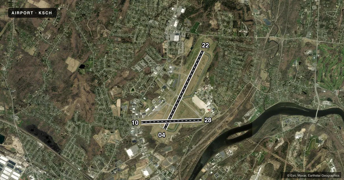
Airport sketch
Runways drawn to scale from FAA survey coordinates, rendered over satellite imagery. Not for navigation.
Approaches & charts
ILS · 1
Services on the field
Fuel grades, oxygen, maintenance, ramp storage and lighting — as declared to the FAA by the airport operator.
Fuel & services
- Fuel
- 100LLA
- Oxygen (bottled)
- Not available
- Oxygen (bulk)
- Low pressure
- Airframe repair
- Minor
- Power plant repair
- Major
- Other services
- AFRT,AMB,AVNCS,CARGO,CHTR,INSTR,RNTL,SALES,SURV
Ramp & ground
- Transient storage
- Tie-down
- Hangar
- Landing fee
- Yes
- Customs
- Not available
- Lighting schedule
- SEE RMK
- Beacon schedule
- SS-SR
- Beacon
- White / Green (civil land)(WG)
- Wind indicator
- Lighted
- Segmented circle
- No
Fuel & FBOs
Cheapest 100LL and Jet A on the field and nearby. Always confirm with the FBO before taxi.
Airport notes
Surface conditions, obstructions, local procedures, lighting outages and other notes published with each FAA cycle.
General notes
- LANDING FEE FOR INTINRNT MULTI-ENGINE ACFT REQUESTING TWR SVC 0330Z-1230Z.
- NO UPDATED FIELD OR BRAKING ACTION REPORTS AVBL BTN 0330Z-1230Z.
- 60 FT DROPOFF 150 FT FM RY 28 END.
- NOISE ABATEMENT PROC IN EFFECT FOR LRGE ACFT REMAINING IN PATTERN CTC AIRFIELD MANAGER FOR DETAILS..
- BIRDS ON & INVOF ARPT.
- MILITARY C130 PATTERN OPERATIONS CONDUCTED DAILY.
- MILITARY: ANG: PPR BASE OPS DURG DUTY HR DSN 344-2621, C518-344-2621; OT COMD POST DSN 344-2420, C518-344-2420.
- MILITARY: CAUTION: BASH PHASE II PERIOD (15 MAR-15 MAY) AND (1 JUL-15 NOV). BIRD WATCH COND (BWC) SVR: TKOFF, LDG & LCL TRNG PROH UNLESS MSN ESTNL; BWC MDT: MULT APCH PROH, DEP & FULL-STOP ALLOWED IF RTE AVOIDS BIRD ACT; CTC ANG AFLD OPS (CALL-SIGN "SKIER OPS") FOR CURRENT BWC.
- MILITARY: ANG APRON: ORANGE DASHED WINGTIP CLNC LINES BOTH SIDES OF YELLOW CENTER TAXILINE. DASHED WINGTIP LINES PROVIDE POSITIVE, CLEARLY IDENTIFIABLE OBST CLNC FOR TAXIING ACFT. ANY OBJECT PARKED ON BACK SIDE OF LINES PROVIDE NO WINGTIP CLNC ISSUE.
- NO ULTRA-LIGHT OPERATONS IN CLASS D AIRSPACE WITHOUT APPROV FM ATCT.
- FLT NOTIFICATION SVC (ADCUS) AVBL.
- FUEL: A++ (MIL).
- FOR CD CTC ALBANY APCH AT 518-862-2299.
- MILITARY: ANG: OPR 1030-2000Z++ MON-FRI, CLSD WKND AND FED HOL. SCHENECTADY COUNTY AIRPORT FONE NR (518)399-0377. COMSEC STORAGE AVBL FOR TRAN CREWS.
- MILITARY: CSTMS/AGG/IMG: 1300-2100Z++ MON-FRI, FONE PRIOR 2000Z++ PRECEDING WKD, C518-431-0200, C800-973-2867.
Lighting notes
- WHEN ATCT CLSD, ACTVT MALSR RWY 04; PAPI RWY 04, 10, 22 & 28; HIRL RWY 04/22; MIRL RWY 10/28 - CTAF.
Approach & departure obstructions
- 22RWY 22 +22FT RISING TERRAIN, 500 FT RT, 0 - 200 FT FM RWY.
- 28RWY 28 +10 FT ROAD, 150 FT - 200 FT FM RWY, 220 FT RT.
- 10RWY 10 CLNC SLOPE 14:1 TO DTHR DUE TO 87 FT TREE, 1223 FT FM DTHR, 190 FT RT.
Other notes
- USE 122.95 FOR SVC FM FBO
VFR map & nearby airports
VFR sectional. Tap any ICAO chip to open that airport.
Key facts · KSCH
Answer card- ICAO
- KSCH
- Name
- SCHENECTADY COUNTY
- Location
- SCHENECTADY, NEW YORK
- Elevation
- 377.9 ft MSL
- Traffic pattern altitude
- 1,377.9 ft MSL (1,000 AGL)
- Control tower
- Towered · 0730-2230 MON-FRI; 0730-2100 WKNDS AND HOLS; CLSD THANKSGIVING & CHRISTMAS; OTR TIMES BY NOTAM.
- Total runways
- 2
- Longest runway
- 04/22 · 7,001 ft
- Published ILS approaches
- 1
- Published frequencies
- 15
- Magnetic variation
- 14°
- Current flight rules
- VFR
- Current wind
- 220° at 4 kt
- Favored runway now
- RWY 22
Schenectady County Airport sits in Schenectady, New York. Field elevation is 377.9 ft MSL. It has two asphalt runways. The longest is Runway 04/22 at 7,001 ft. The other runway is 10/28 at 4,850 ft. The tower is open 0730-2230 Monday through Friday. Weekend and holiday hours are 0730-2100. It is closed on Thanksgiving and Christmas. Other times are by NOTAM.
Runway 04 has the published ILS. Pattern altitude is not published, so use the standard 1,000 ft AGL for light piston operations unless the current Chart Supplement says otherwise. Richmor Aviation is on the field. It carries 100LL, Jet A and Jet A Prist. For clearance delivery, Albany Approach is listed in the remarks. That matters here because the airport sits under a busy controlled environment with both tower and approach services.
A few published notes deserve attention before you go. Noise abatement is in effect for large aircraft remaining in the pattern. Runway 28 has a road close off the right side. Runway 22 has rising terrain near the right side close to the threshold. Runway 10 has a tree on the right side that affects the clearance slope to the displaced threshold. Birds are also reported on and near the airport. Military and customs activity can affect the field during published duty periods. Check the current Chart Supplement and call the airport operator or FBO directly if you need current operating details.