METAR & TAF KPTD
Current METAR
Observed 19:15Z
KPTD 271915Z AUTO 29005KT 10SM SCT050 SCT060 BKN120 28/19 A2976 RMK AO2 PNO
- Wind
- 290° @ 5 kt
- Visibility
- 10 SM
- Temp / Dew
- 28°C / 19°C
- Altimeter
- 29.76 inHg
- Clouds
- BKN
- Density alt
- 2,347 ft
- Ceiling
- 12,000 ft AGL
- Rules
- VFR
Airport info & contacts
Manager on record, flight service, ARTCC, attendance schedule and pattern altitude — published by the FAA and refreshed every 28 days.
Location
- From city
- 2 NM E
- VFR sectional
- MONTREAL
- Pattern altitude
- 800 ft AGL · 1,274 ft MSL
- ARTCC
- ZBW · BOSTON
- NOTAM facility
- PTD (NOTAM-D)
Airport manager
- Name
- BRAD CLEMENTS
- Phone
- 315-268-1000
- Address
- CIVIC CENTER, PO BOX 5168, POTSDAM NY 13676
Flight service · Hours
- FSS BTV
- BURLINGTON1-800-WX-BRIEF
- Attendance
- Unattended
Frequencies
Tap any row to copy the frequency to your clipboard.
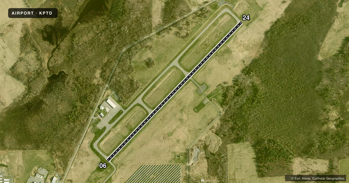
Runways & pattern
Full pagePattern entry · RWY 24
LEFT TRAFFICRunway end performance
| End | TORA | TODA | ASDA | LDA | VGSI | Approach lights | Obstruction |
|---|---|---|---|---|---|---|---|
| 06 | — | — | — | — | PAPI 2-box left(3°) | — | 35', tree, 749' from thr, 200' R of cntrln, slope 15 |
| 24 | — | — | — | — | PAPI 2-box left(3°) | — | 121', trees, 1824' from thr, 286' R of cntrln, slope 13 |
Declared distances in feet. TORA = takeoff run available, TODA = takeoff distance, ASDA = accelerate-stop, LDA = landing distance.
Airport sketch
Runways drawn to scale from FAA survey coordinates, rendered over satellite imagery. Not for navigation.
Approaches & charts
Services on the field
Fuel grades, oxygen, maintenance, ramp storage and lighting — as declared to the FAA by the airport operator.
Fuel & services
- Fuel
- 100LLA
- Oxygen (bottled)
- Not available
- Oxygen (bulk)
- Not available
- Airframe repair
- Major
- Power plant repair
- Major
- Other services
- AMB
Ramp & ground
- Transient storage
- Tie-down
- Landing fee
- No fee published
- Customs
- Not available
- Lighting schedule
- SEE RMK
- Beacon schedule
- SS-SR
- Beacon
- White / Green (civil land)(WG)
- Wind indicator
- Lighted
- Segmented circle
- No
Fuel & FBOs
Cheapest 100LL and Jet A on the field and nearby. Always confirm with the FBO before taxi.
Airport notes
Surface conditions, obstructions, local procedures, lighting outages and other notes published with each FAA cycle.
General notes
- RWY COND NOT MNTD; RCMD VISUAL INSPN PRIOR TO USE.
- DEER ON & INVOF ARPT.
- EXPC FLT TRNG OPNS INVOF ARPT.
- NOISE ABATEMENT PROCS IN EFCT - LEFT TURN WHEN ABLE DEPARTING RWY 24.
- FOR CD CTC BOSTON ARTCC AT 603-879-6859.
Lighting notes
- ACTVT REIL RWY 06 & 24; PAPI RWY 06 & 24; MIRL RWY 06/24; TWY LGTS - CTAF.
Fuel notes
- 100LL24 HR SELF-SERVE
Other notes
- EXISTED PRIOR TO 1959.
- MANAGERHOME 315-268-8839.
VFR map & nearby airports
VFR sectional. Tap any ICAO chip to open that airport.
Key facts · KPTD
Answer card- ICAO
- KPTD
- Name
- POTSDAM MUNI/DAMON FLD
- Location
- POTSDAM, NEW YORK
- Elevation
- 474.3 ft MSL
- Traffic pattern altitude
- 1,274.3 ft MSL (800 AGL)
- Control tower
- Non-towered (use CTAF)
- Total runways
- 1
- Longest runway
- 06/24 · 3,704 ft
- Published ILS approaches
- 0
- Published frequencies
- 2
- Magnetic variation
- 14°
- Current flight rules
- VFR
- Current wind
- 290° at 5 kt
- Favored runway now
- RWY 24
Potsdam Muni/Damon Fld sits in Potsdam, New York. Field elevation is 474.3 ft MSL. The airport has one runway. Runway 06/24 is 3,704 ft of asphalt, so plan performance with that length in mind. There is no control tower. CTAF and UNICOM are both 122.8. Pattern altitude is 800 ft AGL, which is 1,274.3 ft MSL.
No ILS approaches are published here. The field uses medium intensity runway lights on 06/24. Runway end identifier lights are available for both ends. Precision approach path indicators are also available for 06 and 24. Taxiway lights are controlled by the common traffic advisory frequency. The airport carries 100LL, JET A and JET A PRIST through Potsdam Municipal Airport on the field. 100LL is available 24 hours by self-service.
A few local items matter on a first visit. The runway condition is not maintained, so a visual inspection before use is recommended. Expect flight training traffic in the area. Deer are on and near the airport. Noise abatement is in effect. Make a left turn when able after departing runway 24. For clearance delivery, contact Boston ARTCC. If you need current operational details, check the current FAA Chart Supplement or call the airport operator directly.