METAR & TAF KMLI
Current METAR
Observed 12:52Z
KMLI 271252Z 15005KT 10SM CLR 28/26 A2981 RMK AO2 SLP088 T02780256
- Wind
- 150° @ 5 kt
- Visibility
- 10 SM
- Temp / Dew
- 28°C / 26°C
- Altimeter
- 29.81 inHg
- Clouds
- CLR
- Density alt
- 2,428 ft
- Ceiling
- Unlimited
- Rules
- VFR
Airport info & contacts
Manager on record, flight service, ARTCC, attendance schedule and pattern altitude — published by the FAA and refreshed every 28 days.
Location
- From city
- 3 NM S
- VFR sectional
- CHICAGO
- ARTCC
- ZAU · CHICAGO
- NOTAM facility
- MLI (NOTAM-D)
Airport manager
- Name
- BENJAMIN LEISCHNER
- Phone
- 309-757-1768
- Address
- 2200 GEORGE KIRK DR.; SUITE 100, MOLINE IL 61265
Flight service · Hours
- FSS IKK
- KANKAKEE1-800-WX-BRIEF
- Attendance
- ALL
Frequencies
Tap any row to copy the frequency to your clipboard.
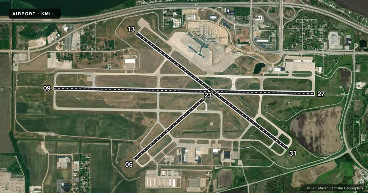
Runways & pattern
Full pagePattern entry · RWY 13
LEFT TRAFFIC| Runway | Heading (°M) | Length | Surface | Traffic |
|---|---|---|---|---|
| 09/27 | 90° / 270° | 10,002 ft | CONC | Standard L |
| 13/31Favored | 126° / 306° | 7,301 ft | ASPH-CONC | Standard L |
| 05/23 | 48° / 228° | 3,514 ft | CONC | Standard L |
Runway end performance
| End | TORA | TODA | ASDA | LDA | VGSI | Approach lights | Obstruction |
|---|---|---|---|---|---|---|---|
| 09 | 10,002' | 10,002' | 10,002' | 10,002' | PAPI 4-box left(3°) | MALSR | — |
| 27 | 10,002' | 10,002' | 10,002' | 10,002' | PAPI 4-box left(3°) | MALSR | 207', tree, 8959' from thr, 1743' R of cntrln, slope 42 |
| 13 | 7,301' | 7,301' | 7,032' | 7,032' | PAPI 4-box left(3°) | — | 45', tree, 1665' from thr, 271' R of cntrln, slope 32 |
| 31 | 7,301' | 7,301' | 6,954' | 6,432' | PAPI 4-box left(3°) | — | 173', tree, 5522' from thr, 559' R of cntrln, slope 30 |
| 05 | 3,514' | 3,514' | 3,514' | 3,514' | PAPI 4-box left(4°) | — | — |
| 23 | 3,514' | 3,514' | 3,514' | 3,514' | PAPI 4-box left(3°) | — | — |
Declared distances in feet. TORA = takeoff run available, TODA = takeoff distance, ASDA = accelerate-stop, LDA = landing distance.
Airport sketch
Runways drawn to scale from FAA survey coordinates, rendered over satellite imagery. Not for navigation.
Approaches & charts
ILS · 2
Services on the field
Fuel grades, oxygen, maintenance, ramp storage and lighting — as declared to the FAA by the airport operator.
Fuel & services
- Fuel
- 100LLA
- Oxygen (bottled)
- HIGH/LOW
- Oxygen (bulk)
- HIGH/LOW
- Airframe repair
- Major
- Power plant repair
- Major
- Other services
- AVNCS,CARGO,CHTR,INSTR
Ramp & ground
- Transient storage
- Tie-down
- Hangar
- Landing fee
- Yes
- Customs
- Not available
- Lighting schedule
- SEE RMK
- Beacon schedule
- SS-SR
- Beacon
- White / Green (civil land)(WG)
- Wind indicator
- Lighted
- Segmented circle
- Yes
Fuel & FBOs
Cheapest 100LL and Jet A on the field and nearby. Always confirm with the FBO before taxi.
Airport notes
Surface conditions, obstructions, local procedures, lighting outages and other notes published with each FAA cycle.
General notes
- BIRDS & MIGRATORY FOWL ON & INVOF ARPT.
Lighting notes
- WHEN ATCT CLSD ACTVT AND INCR INTS RWY & TWY LIGHTING, MALSR RWY 9 & RWY 27; REIL RWY 13 & RWY 31 - CTAF.
Fuel notes
- 100LL100LL SELF SERVE FUEL PUMP LCTD IN T-HNGR AREA AND OPEN 24 HRS A DAY.
Runway surface & condition
- 05/23PCR VALUE: 350/R/C/W/T
- 09/27PCR VALUE: 750/R/C/W/T
- 13/31PCR VALUE: 590/R/C/W/T
Approach & departure obstructions
- 31140 FT PWR POLE DIST 5836 FT; 415 FT R; 41:1 BASED ON DSPLCD THLD.
Other notes
- ARFF INDEX C AVBL ON REQ; 24 HR PPR CALL AMGR (309) 757-1739
- LDG FEES FOR TSNT ACFT 12,500 LBS AND GTR.
VFR map & nearby airports
VFR sectional. Tap any ICAO chip to open that airport.
Key facts · KMLI
Answer card- ICAO
- KMLI
- Name
- QUAD CITIES INTL
- Location
- MOLINE, ILLINOIS
- Elevation
- 589.6 ft MSL
- Traffic pattern altitude
- 1,589.6 ft MSL (1,000 AGL)
- Control tower
- Towered · 0530-2230
- Total runways
- 3
- Longest runway
- 09/27 · 10,002 ft
- Published ILS approaches
- 2
- Published frequencies
- 15
- Magnetic variation
- 1°
- Current flight rules
- VFR
- Current wind
- 150° at 5 kt
- Favored runway now
- RWY 13
Quad Cities Intl is in Moline, Illinois. The field elevation is 589.6 ft MSL. It has three runways. The longest is 10,002 ft on 09/27. The airport is towered. Tower hours are 0530-2230. Two ILS approaches are published for runway ends 09 and 27.
Pattern altitude is not published in the facts. Use the standard 1,000 ft AGL for light piston traffic unless ATC or the current Chart Supplement says otherwise. The field sits in a busy metro area, so expect normal tower coordination and pay attention to traffic flow near the Class D environment. Birds and migratory fowl are reported on and near the airport. That matters on departure and arrival.
QCIA Airport Services is on the field. It carries 100LL and Jet A. Elliott Aviation is also on the field. It carries 100LL and Jet A Prist. A 24-hour self-serve 100LL pump is in the T-hangar area. When the tower is closed, lighting can be activated and brightened by using CTAF. That includes runway and taxiway lights. MALSR on 09 and 27 can also be activated that way. REIL on 13 and 31 is handled the same way. Runway 31 has a published power pole obstruction note near the departure path. Check the current Chart Supplement if you plan a departure from that end.