METAR & TAF KLIT
Current METAR
Observed 18:53Z
KLIT 271853Z 25007KT 10SM FEW065 37/19 A2989 RMK AO2 SLP120 T03720194
- Wind
- 250° @ 7 kt
- Visibility
- 10 SM
- Temp / Dew
- 37°C / 19°C
- Altimeter
- 29.89 inHg
- Clouds
- FEW
- Density alt
- 3,007 ft
- Ceiling
- Unlimited
- Rules
- VFR
Airport info & contacts
Manager on record, flight service, ARTCC, attendance schedule and pattern altitude — published by the FAA and refreshed every 28 days.
Location
- From city
- 2 NM E
- VFR sectional
- MEMPHIS
- ARTCC
- ZME · MEMPHIS
- NOTAM facility
- LIT (NOTAM-D)
Airport manager
- Name
- DAVID TIPTON
- Phone
- 501-537-7311
- Address
- 1 AIRPORT DRIVE, LITTLE ROCK AR 72202
Flight service · Hours
- FSS JBR
- JONESBORO1-800-WX-BRIEF
- Attendance
- ALL
Frequencies
Tap any row to copy the frequency to your clipboard.
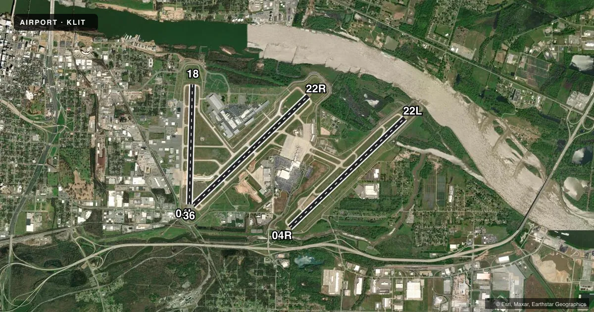
Runways & pattern
Full pagePattern entry · RWY 22R
RIGHT TRAFFIC| Runway | Heading (°M) | Length | Surface | Traffic |
|---|---|---|---|---|
| 04L/22RFavored | 47° / 227° | 8,273 ft | CONC | 22R R |
| 04R/22L | 47° / 227° | 8,251 ft | CONC | 04R R |
| 18/36 | 182° / 2° | 6,224 ft | CONC | Standard L |
Runway end performance
| End | TORA | TODA | ASDA | LDA | VGSI | Approach lights | Obstruction |
|---|---|---|---|---|---|---|---|
| 04L | 8,273' | 8,273' | 8,273' | 7,976' | PAPI 4-box left(3°) | MALSR | 23', rr, 670' from thr, 557' R of cntrln, slope 20 |
| 22R | 8,273' | 8,273' | 8,273' | 8,273' | PAPI 4-box right(3°) | ALSF2 | — |
| 04R | 8,250' | 8,250' | 8,250' | 7,200' | PAPI 4-box right(3°) | MALSR | 78', pole, 2874' from thr, 820' R of cntrln, slope 34 |
| 22L | 7,200' | 7,200' | 7,200' | 7,200' | PAPI 4-box left(3°) | MALSF | 72', trees, 3301' from thr, 754' R of cntrln, slope 43 |
| 18 | 6,060' | 6,060' | 6,060' | 6,060' | PAPI 4-box left(3°) | — | 35', tree, 1286' from thr, 164' R of cntrln, slope 31 |
| 36 | 6,224' | 6,224' | 6,224' | 6,060' | PAPI 4-box right(3.75°) | — | 105', trees, 2489' from thr, 351' R of cntrln, slope 21 |
Declared distances in feet. TORA = takeoff run available, TODA = takeoff distance, ASDA = accelerate-stop, LDA = landing distance.
Airport sketch
Runways drawn to scale from FAA survey coordinates, rendered over satellite imagery. Not for navigation.
Approaches & charts
ILS · 4
Services on the field
Fuel grades, oxygen, maintenance, ramp storage and lighting — as declared to the FAA by the airport operator.
Fuel & services
- Fuel
- 100LLA
- Oxygen (bottled)
- High pressure
- Oxygen (bulk)
- High pressure
- Airframe repair
- Major
- Power plant repair
- Major
- Other services
- AFRT,AMB,AVNCS,CARGO,CHTR,INSTR,RNTL,SALES,SURV
Ramp & ground
- Transient storage
- Tie-down
- Hangar
- Landing fee
- Yes
- Customs
- Not available
- Lighting schedule
- SS-SR
- Beacon schedule
- SS-SR
- Beacon
- White / Green (civil land)(WG)
- Wind indicator
- Lighted
- Segmented circle
- No
Fuel & FBOs
Cheapest 100LL and Jet A on the field and nearby. Always confirm with the FBO before taxi.
Airport notes
Surface conditions, obstructions, local procedures, lighting outages and other notes published with each FAA cycle.
General notes
- LARGE CONCENTRATIONS OF BIRDS INVOF ARPT; MOST ACTIVITY BTN SR-SS UP TO 1500 FT MSL.
- CARGO & TERMINAL RAMPS ARE NON-MOVEMENT AREAS.
- NO GENERAL AVIATION PARKING ON TERMINAL OR CARGO RAMP.
- TWY A 315 FT SOUTH OF TWY A6 INTERSECTION TO RWY 36 CLSD EXCEPT ACFT WITH WINGSPAN LESS THAN 79 FT.
- BE ALERT: NORTH LITTLE ROCK MUNI AIRPORT IS LCTD 6 MILES NNW WITH SIMILAR RUNWAY CONFIGURATIONS.
- FOR CD WHEN UNA VIA FREQ CTC LITTLE ROCK APCH 501-379-2908 OR LITTLE ROCK ATCT 501-379-2911.
- SMGCS SUSPENDED UFN.
- PSGR ACR ACFT ADG-IV AND HYR RESTRICTED FROM USING TWY F BTN TWY E AND ATLANTIC AVN/ENVOY HNGR RAMP DUE TO NON-STD SAFETY AREA
Runway surface & condition
- 04L/22RPCR VALUE: 865/R/B/W/T
- 04R/22LPCR VALUE: 719/R/A/W/T
- 18/36PCR VALUE: 347/R/B/W/T
Approach & departure obstructions
- 04LAPCH RATIO 42:1 FM DSPLCD THLD.
- 18APCH RATIO 39:1 BASED ON DSPLCD THLD +35 FT TREE 1385 FT DIST 164 FT LEFT.
- 36APCH RATIO 24:1 BASED ON DSPLCD THLD; 105 FT TREES 2579 FT DIST 351 FT R.
Arresting gear
- 22R_EMASENGINEERED MATERIALS ARRESTING SYSTEM (EMAS) 262.6 FT IN LENGTH BY 169.7 FT IN WIDTH LCTD AT THE DER 22R.
VFR map & nearby airports
VFR sectional. Tap any ICAO chip to open that airport.
Key facts · KLIT
Answer card- ICAO
- KLIT
- Name
- BILL AND HILLARY CLINTON NTL/ADAMS FLD
- Location
- LITTLE ROCK, ARKANSAS
- Elevation
- 266 ft MSL
- Traffic pattern altitude
- 1,266 ft MSL (1,000 AGL)
- Control tower
- Towered · 24
- Total runways
- 3
- Longest runway
- 04L/22R · 8,273 ft
- Published ILS approaches
- 4
- Published frequencies
- 18
- Magnetic variation
- 0°
- Current flight rules
- VFR
- Current wind
- 250° at 7 kt
- Favored runway now
- RWY 22R
Bill and Hillary Clinton Ntl/Adams Fld sits in Little Rock, Arkansas. Field elevation is 266 ft MSL. This is a towered airport with the control tower open 24 hours. The airport has 3 runways. The longest is 8,273 ft. Four ILS approaches are published. They serve runway ends 04L, 04R, 22L and 22R.
Pattern altitude is not published in the facts. Use the standard 1,000 ft AGL for light piston traffic unless ATC or the current Chart Supplement says otherwise. The field is in the Little Rock Class C area. Expect busy commercial and general aviation traffic. Large bird activity is a real factor here. The published remarks say most bird movement is between sunrise and sunset up to 1,500 ft MSL. That matters on departure and arrival.
Signature Aviation is on the field. It carries 100LL and Jet A. Atlantic Aviation is also on the field. It carries 100LL and Jet A. The airport also has an EMAS at the departure end of 22R. Surface movement guidance and control system is suspended until further notice. If you are new to the field, brief the taxi plan carefully. Passenger aircraft with Airplane Design Group four and higher have a taxiway restriction between taxiway E and the Atlantic Avenue or Envoy hangar ramp. Check the current Chart Supplement for any current noise or operational notes before you go.