METAR & TAF KJDD
Current METAR
Observed 17:55Z
KJDD 111755Z AUTO 20012G17KT 10SM OVC050 31/24 A2987 RMK AO2 T03070241 $
- Wind
- 200° @ 12G17 kt
- Visibility
- 10 SM
- Temp / Dew
- 31°C / 24°C
- Altimeter
- 29.87 inHg
- Clouds
- OVC
- Density alt
- 2,519 ft
- Ceiling
- 5,000 ft AGL
- Rules
- VFR
Airport info & contacts
Manager on record, flight service, ARTCC, attendance schedule and pattern altitude — published by the FAA and refreshed every 28 days.
Location
- From city
- 5 NM N
- VFR sectional
- DALLAS-FT WORTH
- ARTCC
- ZFW · FORT WORTH
- NOTAM facility
- JDD (NOTAM-D)
Airport manager
- Name
- JOHN WISDOM
- Phone
- 903-768-2100
- Address
- 317 COUNTY RD 2355, MINEOLA TX 75773-3715
Flight service · Hours
- FSS FTW
- FORT WORTH1-800-WX-BRIEF
- Attendance
- M-F · 0900-1700
Frequencies
Tap any row to copy the frequency to your clipboard.
Runways & pattern
Full pagePattern entry · RWY 18
LEFT TRAFFICRunway end performance
| End | TORA | TODA | ASDA | LDA | VGSI | Approach lights | Obstruction |
|---|---|---|---|---|---|---|---|
| 18 | — | — | — | — | PAPI 2-box left(3°) | — | 90', trees, 2000' from thr, 0' R of cntrln, slope 20 |
| 36 | — | — | — | — | PAPI 2-box left(3°) | — | 70', trees, 201' from thr, 234' R of cntrln, slope 0 |
Declared distances in feet. TORA = takeoff run available, TODA = takeoff distance, ASDA = accelerate-stop, LDA = landing distance.
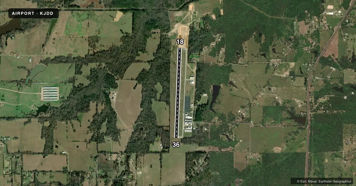
Airport sketch
Runways drawn to scale from FAA survey coordinates, rendered over satellite imagery. Not for navigation.
Approaches & charts
Services on the field
Fuel grades, oxygen, maintenance, ramp storage and lighting — as declared to the FAA by the airport operator.
Fuel & services
- Fuel
- 100LLA
- Airframe repair
- Major
- Power plant repair
- Major
- Other services
- INSTR
Ramp & ground
- Transient storage
- Tie-down
- Hangar
- Lighting schedule
- SEE RMK
- Beacon schedule
- SS-SR
- Beacon
- White / Green (civil land)(WG)
- Wind indicator
- Lighted
- Segmented circle
- Yes
Fuel & FBOs
Cheapest 100LL and Jet A on the field and nearby. Always confirm with the FBO before taxi.
Airport notes
Surface conditions, obstructions, local procedures, lighting outages and other notes published with each FAA cycle.
General notes
- BLUE TWY CNTRLN REFLECTORS.
- WILDLIFE INVOF ARPT.
- FOR CD CTC FORT WORTH ARTCC AT 817-858-7584.
Lighting notes
- MIRL RWY 18/36 PRESET LOW INTST DUSK-DAWN; TO INCR INTST ACTVT - CTAF. PAPI RWYS 18 & 36 OPR CONSLY.
Fuel notes
- 100LLSELF SERVE FUEL.
Approach & departure obstructions
- 3670 FT TREES 45-200 FT DSTC, 234 FT R.
- 36PAPI UNUSBL 6 DEGS LEFT OF CNTRLN.
Other notes
- 04 NM SW OF QUITMAN.
- ASST_MGRERIN@WOODCOUNTYAIRPORT.NET
VFR map & nearby airports
VFR sectional. Tap any ICAO chip to open that airport.
Key facts · KJDD
Answer card- ICAO
- KJDD
- Name
- WOOD COUNTY/COLLINS FLD
- Location
- MINEOLA/QUITMAN, TEXAS
- Elevation
- 432.9 ft MSL
- Traffic pattern altitude
- 1,432.9 ft MSL (1,000 AGL)
- Control tower
- Non-towered (use CTAF)
- Total runways
- 1
- Longest runway
- 18/36 · 4,002 ft
- Published ILS approaches
- 0
- Published frequencies
- 4
- Magnetic variation
- 2°
- Current flight rules
- VFR
- Current wind
- 200° at 12 kt
- Favored runway now
- RWY 18
Wood County/Collins Fld sits near Mineola and Quitman in Texas. The field elevation is 432.9 ft MSL. It has one runway, 18/36, which is 4,002 ft asphalt. There is no control tower. Pattern altitude is not published, so use 1,000 ft AGL for light piston traffic unless the current Chart Supplement says otherwise.
No ILS approaches are published here. The airport uses CTAF and UNICOM on 122.8. Longview Approach and Departure are on 128.75 and 379.15. For clearance delivery, contact Fort Worth ARTCC at 817-858-7584. East Texas Flying Service is the on-field FBO. It carries AVGAS 100LL and Jet A. Self-serve 100LL is available.
A few operational items matter here. Wildlife is reported in the vicinity of the airport. Runway 18/36 has medium intensity lights that sit at low intensity from dusk to dawn. You can increase intensity by keying the CTAF. The PAPIs on both ends operate continuously. The PAPI for runway 36 is unusable 6 degrees left of centerline. There are also 70-foot trees 45 to 200 feet from the runway, 234 feet right of runway 36. Blue taxiway centerline reflectors are installed. If you are planning a first arrival, brief the runway 36 side carefully and verify current conditions with the airport operator if anything looks off.