METAR & TAF KHOC
KHOC does not publish a METAR.
Showing the nearest reporting station: KILN (WILMINGTON AIR PARK) · 18.6 NM away. Conditions at KHOC may differ.
METAR · KILN
Observed 12:54Z
KILN 121254Z AUTO 25011KT 10SM BKN080 22/19 A2993 RMK AO2 SLP122 T02170194
- Wind
- 250° @ 11 kt
- Visibility
- 10 SM
- Temp / Dew
- 22°C / 19°C
- Altimeter
- 29.93 inHg
- Clouds
- BKN
- Density alt
- 2,039 ft
- Ceiling
- 8,000 ft AGL
- Rules
- VFR
Airport info & contacts
Manager on record, flight service, ARTCC, attendance schedule and pattern altitude — published by the FAA and refreshed every 28 days.
Location
- From city
- 3 NM SE
- VFR sectional
- CINCINNATI
- Pattern altitude
- 700 ft AGL · 1,677 ft MSL
- ARTCC
- ZID · INDIANAPOLIS
- NOTAM facility
- DAY (NOTAM-D)
Airport manager
- Name
- BOB PROSEK, AIRPORT AUTH PRESIDENT
- Phone
- 937-393-9112
- Address
- 9500 N SHORE DR, HILLSBORO OH 45133-7799
Flight service · Hours
- FSS DAY
- DAYTON1-800-WX-BRIEF
- Attendance
- 0800-1700
Frequencies
Tap any row to copy the frequency to your clipboard.
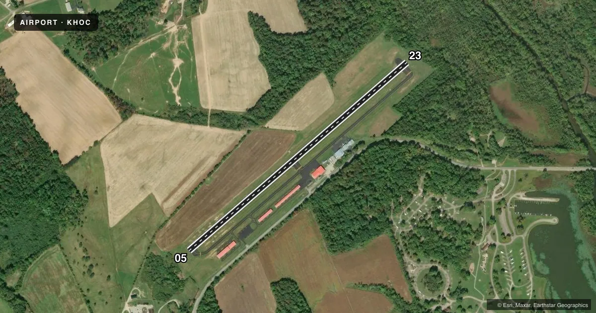
Runways & pattern
Full pagePattern entry · RWY 23
LEFT TRAFFICRunway end performance
| End | TORA | TODA | ASDA | LDA | VGSI | Approach lights | Obstruction |
|---|---|---|---|---|---|---|---|
| 05 | — | — | — | — | — | — | 25', trees, 418' from thr, 176' R of cntrln, slope 8 |
| 23 | — | — | — | — | PAPI 2-box left(4°) | — | 50', trees, 903' from thr, 282' R of cntrln, slope 14 |
Declared distances in feet. TORA = takeoff run available, TODA = takeoff distance, ASDA = accelerate-stop, LDA = landing distance.
Airport sketch
Runways drawn to scale from FAA survey coordinates, rendered over satellite imagery. Not for navigation.
Approaches & charts
Services on the field
Fuel grades, oxygen, maintenance, ramp storage and lighting — as declared to the FAA by the airport operator.
Fuel & services
- Fuel
- 100LL
- Oxygen (bottled)
- Not available
- Oxygen (bulk)
- Not available
- Airframe repair
- Major
- Power plant repair
- Major
Ramp & ground
- Transient storage
- Tie-down
- Hangar
- Landing fee
- No fee published
- Customs
- Not available
- Lighting schedule
- SEE RMK
- Beacon schedule
- SS-SR
- Beacon
- White / Green (civil land)(WG)
- Wind indicator
- Lighted
- Segmented circle
- No
Fuel & FBOs
Cheapest 100LL and Jet A on the field and nearby. Always confirm with the FBO before taxi.
Airport notes
Surface conditions, obstructions, local procedures, lighting outages and other notes published with each FAA cycle.
General notes
- DEER & BIRDS ON & INVOF ARPT.
- FOR CD IF UNA TO CTC ON FSS FREQ, CTC INDIANAPOLIS ARTCC AT 317-247-2411.
Lighting notes
- ACTVT REIL RWY 05 & 23; PAPI RWY 23; MIRL RWY 05/23 - CTAF.
Fuel notes
- 100LLAVBL H24 SELF SVC VIA CREDIT CARD.
Approach & departure obstructions
- 23+50 TREE, 81 FT DIST, 139 FT R; +5-15 FT TREES & BRUSH, 160 FT DIST, 250 FT L/R.
Other notes
- THIS AIRPORT HAS BEEN SURVEYED BY THE NATIONAL GEODETIC SURVEY.
VFR map & nearby airports
VFR sectional. Tap any ICAO chip to open that airport.
Key facts · KHOC
Answer card- ICAO
- KHOC
- Name
- HIGHLAND COUNTY
- Location
- HILLSBORO, OHIO
- Elevation
- 977.3 ft MSL
- Traffic pattern altitude
- 1,677.3 ft MSL (700 AGL)
- Control tower
- Non-towered (use CTAF)
- Total runways
- 1
- Longest runway
- 05/23 · 3,520 ft
- Published ILS approaches
- 0
- Published frequencies
- 2
- Magnetic variation
- 5°
- Current flight rules
- VFR
- Current wind
- 250° at 11 kt
- Favored runway now
- RWY 23
Highland County Airport sits in Hillsboro, Ohio. Field elevation is 977.3 ft MSL. The airport has one runway. Runway 05/23 is 3,520 ft long and asphalt. There is no control tower. CTAF and UNICOM are both 123.05. No ILS approaches are published here, so plan with the current chart and your own arrival setup.
Pattern altitude is 700 ft AGL, which is 1,677.3 ft MSL. That matters here because the field is not flat country flying. The published remarks also call out trees near runway 23. Pay attention on short final and during departure planning. Deer and birds are reported on and near the airport. Keep that in mind during taxi, takeoff and landing.
Highland County Airport is the on-field FBO. It carries 100LL. Self-serve 100LL is available 24 hours a day with a credit card. The runway has medium intensity lights, runway end identifier lights on 05 and 23 and a PAPI on runway 23. If you need clearance delivery and cannot raise Flight Service, the published remark says to contact Indianapolis ARTCC. For any current procedure details or local restrictions, check the current FAA Chart Supplement or call the airport operator directly before you go.