METAR & TAF KFKN
Current METAR
Observed 21:15Z
KFKN 112115Z AUTO 24005KT 10SM CLR 36/19 A2982 RMK AO2 T03560185
- Wind
- 240° @ 5 kt
- Visibility
- 10 SM
- Temp / Dew
- 36°C / 19°C
- Altimeter
- 29.82 inHg
- Clouds
- CLR
- Density alt
- 2,694 ft
- Ceiling
- Unlimited
- Rules
- VFR
Airport info & contacts
Manager on record, flight service, ARTCC, attendance schedule and pattern altitude — published by the FAA and refreshed every 28 days.
Location
- From city
- 2 NM NE
- VFR sectional
- WASHINGTON
- ARTCC
- ZDC · WASHINGTON
- NOTAM facility
- FKN (NOTAM-D)
Airport manager
- Name
- TREVELYN LINTON
- Phone
- 757-562-8764
- Address
- 32470 JOHN BEVERLY ROSE DR, FRANKLIN VA 23851
Flight service · Hours
- FSS DCA
- LEESBURG1-800-WX-BRIEF
- Attendance
- 0800-1700
Frequencies
Tap any row to copy the frequency to your clipboard.
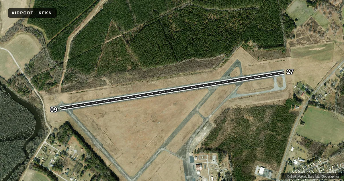
Runways & pattern
Full pagePattern entry · RWY 27
LEFT TRAFFICRunway end performance
| End | TORA | TODA | ASDA | LDA | VGSI | Approach lights | Obstruction |
|---|---|---|---|---|---|---|---|
| 09 | — | — | — | — | PAPI 2-box left(3°) | — | 29', tree, 422' from thr, 127' R of cntrln, slope 7 |
| 27 | — | — | — | — | PAPI 2-box left(3°) | — | 83', tree, 1224' from thr, 398' R of cntrln, slope 12 |
Declared distances in feet. TORA = takeoff run available, TODA = takeoff distance, ASDA = accelerate-stop, LDA = landing distance.
Airport sketch
Runways drawn to scale from FAA survey coordinates, rendered over satellite imagery. Not for navigation.
Approaches & charts
Services on the field
Fuel grades, oxygen, maintenance, ramp storage and lighting — as declared to the FAA by the airport operator.
Fuel & services
- Fuel
- 100LLA
- Oxygen (bottled)
- Not available
- Oxygen (bulk)
- Not available
- Airframe repair
- Major
- Power plant repair
- Major
- Other services
- AGRI,RNTL
Ramp & ground
- Transient storage
- Tie-down
- Landing fee
- No fee published
- Customs
- Not available
- Lighting schedule
- SEE RMK
- Beacon schedule
- SS-SR
- Beacon
- White / Green (civil land)(WG)
- Wind indicator
- Lighted
- Segmented circle
- No
Fuel & FBOs
Cheapest 100LL and Jet A on the field and nearby. Always confirm with the FBO before taxi.
Airport notes
Surface conditions, obstructions, local procedures, lighting outages and other notes published with each FAA cycle.
General notes
- DEER ON AND INVOF ARPT.
- PSBL TFC FM THE SOUTHAMPTON MEMORIAL HELIPAD 2 NM W OF ARPT.
- DRAINAGE DITCHES NEXT TO RWY & TWYS.
- FOR CD CTC NORFOLK APCH AT 757-464-0757.
- ARPT FBO CLSD SAT AND SUN.
Lighting notes
- ACTVT MIRL 09/27 - CTAF.
Approach & departure obstructions
- 274 FT HIGH FENCE 139 FT FM RWY END, 242 FT L ON APCH.
- 27RWY 27 PAPI UNUSABLE BYD 1 NM FM THR.
Other notes
- IN OPERATION PRIOR TO 1959.
- <TPA LGT ACFT 800 FT, HVY ACFT 1500 FT.
- MANAGERCTC 757-562-8575 FOR AFTER HOUR EMERGENCIES.
VFR map & nearby airports
VFR sectional. Tap any ICAO chip to open that airport.
Key facts · KFKN
Answer card- ICAO
- KFKN
- Name
- FRANKLIN RGNL
- Location
- FRANKLIN, VIRGINIA
- Elevation
- 40.3 ft MSL
- Traffic pattern altitude
- 1,040.3 ft MSL (1,000 AGL)
- Control tower
- Non-towered (use CTAF)
- Total runways
- 1
- Longest runway
- 09/27 · 4,977 ft
- Published ILS approaches
- 0
- Published frequencies
- 4
- Magnetic variation
- 9°
- Current flight rules
- VFR
- Current wind
- 240° at 5 kt
- Favored runway now
- RWY 27
Franklin Rgnl sits in Franklin, Virginia at 40.3 ft MSL. It has one runway, 09/27, which is 4,977 ft long and asphalt. The field is non-towered. Pattern altitude for light aircraft is 800 ft AGL. Heavy aircraft use 1,500 ft AGL.
No ILS approaches are published here. For clearance delivery, Norfolk Approach handles it. The published frequencies are CTAF 122.8 and UNICOM 122.8. Approach and departure service is on 127.9 or 269.425. Medium intensity runway lights on 09/27 are pilot-controlled through CTAF.
Franklin Municipal Airport is the on-field FBO. It carries AVGAS 100LL and Jet A. The FBO is closed Saturday and Sunday. If you need after-hours help, the published emergency contact is 757-562-8575.
First-time pilots should watch the details. There is a fence near the runway end on 27. Drainage ditches run next to the runway and taxiways. Deer are reported on and near the airport. Runway 27 PAPI is unusable beyond 1 NM from the threshold. There may also be traffic from the Southampton Memorial helipad 2 NM west of the field. Check the current FAA Chart Supplement for any noise or curfew restrictions before flying in.