METAR & TAF KDSM
Current METAR
Observed 17:54Z
KDSM 271754Z 23011KT 10SM FEW100 FEW160 SCT250 32/24 A2976 RMK AO2 LTG DSNT S AND SW SLP067 CB DSNT SE-W MOV SE T03220244 10333 20272 58006
- Wind
- 230° @ 11 kt
- Visibility
- 10 SM
- Temp / Dew
- 32°C / 24°C
- Altimeter
- 29.76 inHg
- Clouds
- SCT
- Density alt
- 3,426 ft
- Ceiling
- Unlimited
- Rules
- VFR
Airport info & contacts
Manager on record, flight service, ARTCC, attendance schedule and pattern altitude — published by the FAA and refreshed every 28 days.
Location
- From city
- 3 NM SW
- VFR sectional
- OMAHA
- ARTCC
- ZMP · MINNEAPOLIS
- NOTAM facility
- DSM (NOTAM-D)
Airport manager
- Name
- MR. BRIAN MULCAHY
- Phone
- 515-256-5100
- Address
- 5800 FLEUR DRIVE, SUITE 207, DES MOINES IA 50321-2854
Flight service · Hours
- FSS FOD
- FORT DODGE1-800-WX-BRIEF
- Attendance
- ALL
Frequencies
Tap any row to copy the frequency to your clipboard.
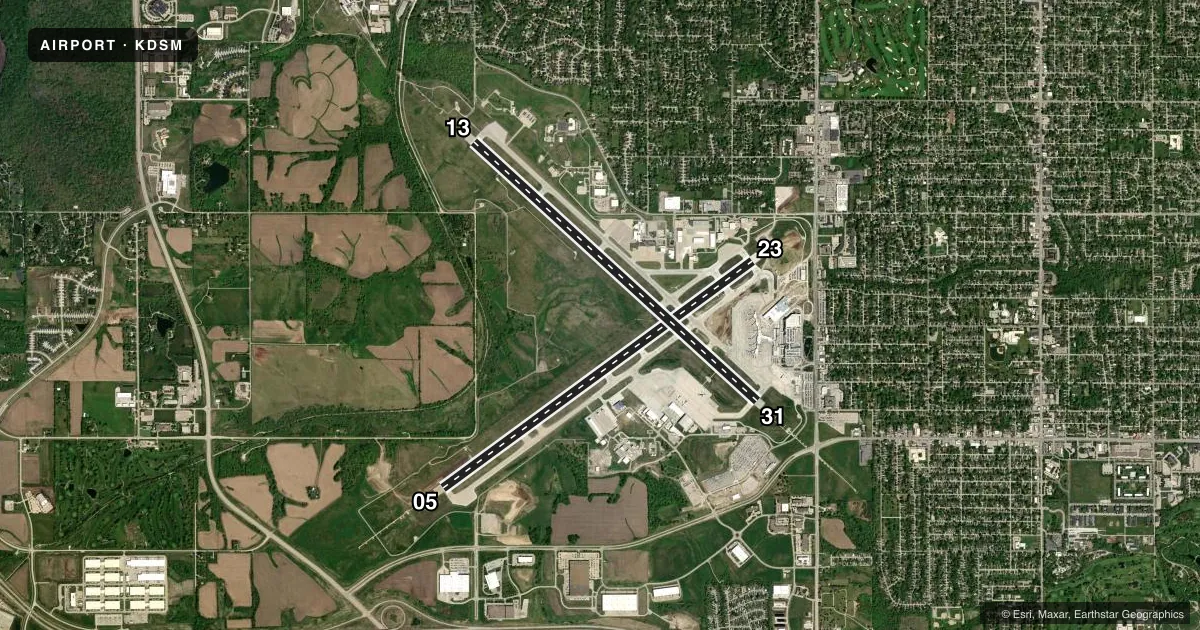
Runways & pattern
Full pagePattern entry · RWY 23
LEFT TRAFFIC| Runway | Heading (°M) | Length | Surface | Traffic |
|---|---|---|---|---|
| 05/23Favored | 53° / 233° | 9,004 ft | CONC | Standard L |
| 13/31 | 131° / 311° | 9,001 ft | CONC | 31 R |
Runway end performance
| End | TORA | TODA | ASDA | LDA | VGSI | Approach lights | Obstruction |
|---|---|---|---|---|---|---|---|
| 05 | — | — | — | — | PAPI 4-box left(3°) | MALSR | — |
| 23 | — | — | — | — | PAPI 4-box left(3°) | — | 67', pole, 2322' from thr, 375' R of cntrln, slope 34 |
| 13 | 9,001' | 9,001' | 9,001' | 9,001' | PAPI 4-box right(3°) | MALSR | — |
| 31 | 9,001' | 9,001' | 9,001' | 9,001' | PAPI 4-box left(3°) | ALSF2 | — |
Declared distances in feet. TORA = takeoff run available, TODA = takeoff distance, ASDA = accelerate-stop, LDA = landing distance.
Airport sketch
Runways drawn to scale from FAA survey coordinates, rendered over satellite imagery. Not for navigation.
Approaches & charts
ILS · 3
Services on the field
Fuel grades, oxygen, maintenance, ramp storage and lighting — as declared to the FAA by the airport operator.
Fuel & services
- Fuel
- 100LLA
- Oxygen (bottled)
- HIGH/LOW
- Oxygen (bulk)
- HIGH/LOW
- Airframe repair
- Major
- Power plant repair
- Major
- Other services
- AFRT,AMB,AVNCS,CARGO,CHTR,SALES,SURV
Ramp & ground
- Transient storage
- Tie-down
- Hangar
- Landing fee
- No fee published
- Customs
- Not available
- Beacon schedule
- SS-SR
- Beacon
- White / Green (civil land)(WG)
- Wind indicator
- Lighted
- Segmented circle
- No
Fuel & FBOs
Cheapest 100LL and Jet A on the field and nearby. Always confirm with the FBO before taxi.
Airport notes
Surface conditions, obstructions, local procedures, lighting outages and other notes published with each FAA cycle.
General notes
- MODERN AVIATION FBO LCTD AT NORTH GA APRON.
- CONTR FUEL - 515-256-5330.
- BIRDS ON & INVOF ARPT.
- INFORMAL NOISE ABATEMENT PROCEDURES IN EFFECT. EXPECT ATC TO ASSIGN PREFERRED RY.
- IANG SOUTH RAMP PCN 78 R/B/W/T. IANG WEST RAMP PCN 87 R/B/W/T.
- MAX ACFT WT SOUTH GA APRN 170,000 LBS ALL OTHER FBO APRN 80,000 LBS.
- RWY 05 APCH END HAS LTD VIS FROM THE TWR. TWR CANNOT EASILY ID IF AN ACFT IS OVER THE HOLD SHORT LINE AT TWY P7. RWY 05 ARRIVALS - USE CTN AND ENSURE YOU ARE CORRECTLY LINED UP WITH RWY 05 AND NOT TWY P.
- CROSS BLEED ENGINE STARTS ON AIR CARRIER RAMP PROHIBITED.
- USE CAUTION WHEN LNDG OVER RAISED LIGHTS IN THE OVERRUNS AND RWY THLDS AT DSM.
- ARNG RAMP AVBL FOR MIL AND MIL-CONTRACTED ACFT FOR OFFL BUS ONLY WITH LTD SUPPORT. PPR; CTC DSN 261-8360/8361, C515-261-8360/8361. FBO WILL PROVIDE CONTRACT FUEL. MIL CREWS CAN CTC HAWKI ON 252.9
- A321 AIRCRAFT LTD TO 190,000 LBS ON RWY 5-23 AND TWY P. A321 EXCEEDING 190,000 LBS WO ARPT AUTH WAIVER REQ ATCT PRVD 13-31.
- TERMINAL APRON TAXILANE ADG III AC ONLY, ADG IV AC AT GATE 25 ONLY.
- TERMINAL APRON TAXILANE ADG III AC ONLY, ADG IV AC AT GATE A4 ONLY.
- TRML APRON TAXILANE ADG III (ACFT WINGSPAN LESS THAN 118 FT) ONLY, ADG IV (ACFT WINGSPAN LESS THAN 172 FT) ACFT AT GATE A4 ONLY.
- TERMINAL APRON DE-ICE SPOT N2 AND ASSOCIATED TAXILANE LIMITED TO ADGII UNLESS COORDINATED WITH IDS 129.875.
- NO TAXI BETWEEN GATES 24 AND 26.
- NO TAXI TO TRML GATES 21/23/25 FROM TXY D1 WHEN AN AIRCRAFT IS PARKED AT REMOTE SPOT R6 - REQUEST TXY E.
- ENTER TERMINAL DE-ICE PAD QUEUE FROM TAXILANE N, DO NOT ENTER PAD FROM TAXILANE N4.
- TWY P E OF TWY D WINGTIP CLEARANCE LIMITED TO 121.5 FT, CAUTION ADVISED FOR ADG V AND LARGER AIRCRAFT.
Runway surface & condition
- 05/23PCR VALUE: 696/R/D/W/T
- 13/31PCR VALUE: 696/R/D/W/T
Approach & departure obstructions
- 23PAPI UNUSBL BYD 9 DEGS RIGHT OF CNTRLN.
Other notes
- FLIGHT NOTIFICATION SERVICE (ADCUS) AVBL MON-FRI 0830-1700. FOR SAT; SUN; HOLS & NIGHT CUSTOMS SVC MAKE APPOINTMENTS MON-FRI 0830-1700. AT LEAST 3 HR ADVANCE NOTICE RQRD.
- MANAGEREXEC DIR
VFR map & nearby airports
VFR sectional. Tap any ICAO chip to open that airport.
Key facts · KDSM
Answer card- ICAO
- KDSM
- Name
- DES MOINES INTL
- Location
- DES MOINES, IOWA
- Elevation
- 957.9 ft MSL
- Traffic pattern altitude
- 1,957.9 ft MSL (1,000 AGL)
- Control tower
- Towered · 24
- Total runways
- 2
- Longest runway
- 05/23 · 9,004 ft
- Published ILS approaches
- 3
- Published frequencies
- 16
- Magnetic variation
- 1°
- Current flight rules
- VFR
- Current wind
- 230° at 11 kt
- Favored runway now
- RWY 23
Des Moines Intl is in Des Moines, Iowa. Field elevation is 957.9 ft MSL. The airport has two concrete runways. The longest is runway 05/23 at 9,004 ft. The tower is open 24 hours. Three ILS approaches are published for runway ends 05, 13 and 31. Pattern altitude is not published in the facts, so use the current Chart Supplement before you fly. For light piston traffic, a standard 1,000 ft AGL pattern is often used. Verify the local procedure before departure.
Modern Aviation and Signature Aviation are both on the field. Modern Aviation is on the north general aviation ramp. Both FBOs carry 100LL and Jet A. If you need customs or ADCUS service, the published remarks say appointments are required for Saturday, Sunday, holidays and night customs service. At least 3 hours notice is required. This is a busy Class C field with airline traffic, so expect close coordination with tower and ground. Runway 05 arrivals need extra attention because the tower has limited visibility of that approach end. The remarks also note a taxiway clearance limit east of taxiway D. Follow de-ice pad routing exactly. Check the current Chart Supplement for any noise or curfew restrictions before flying into the field.