METAR & TAF KCTZ
Current METAR
Observed 06:15Z
KCTZ 240615Z AUTO 00000KT 10SM CLR 20/20 A3004 RMK AO2 T01980198
- Wind
- 000° @ 0 kt
- Visibility
- 10 SM
- Temp / Dew
- 20°C / 20°C
- Altimeter
- 30.04 inHg
- Clouds
- CLR
- Density alt
- 630 ft
- Ceiling
- Unlimited
- Rules
- VFR
Airport info & contacts
Manager on record, flight service, ARTCC, attendance schedule and pattern altitude — published by the FAA and refreshed every 28 days.
Location
- From city
- 2 NM SW
- VFR sectional
- CHARLOTTE
- ARTCC
- ZDC · WASHINGTON
- NOTAM facility
- CTZ (NOTAM-D)
Airport manager
- Name
- JAMES DUNCAN
- Phone
- 910-592-3295
- Address
- 89 SAMPSON AIRPORT ROAD, CLINTON NC 28328
Flight service · Hours
- FSS RDU
- RALEIGH1-800-WX-BRIEF
- Attendance
- MON-SAT · 0830-1800
- SUN · 1300-1800
Frequencies
Tap any row to copy the frequency to your clipboard.
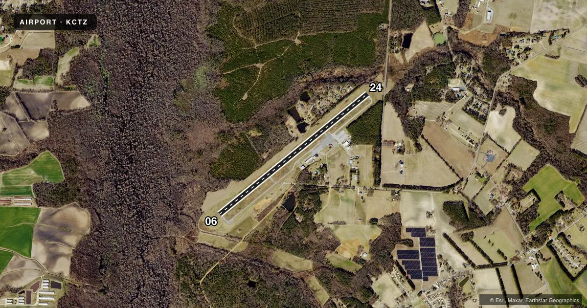
Runways & pattern
Full pagePattern entry · RWY 06
LEFT TRAFFICRunway end performance
| End | TORA | TODA | ASDA | LDA | VGSI | Approach lights | Obstruction |
|---|---|---|---|---|---|---|---|
| 06 | — | — | — | — | PAPI 2-box left(3°) | — | 25', trees, 683' from thr, 452' R of cntrln, slope 19 |
| 24 | — | — | — | — | PAPI 2-box left(3°) | — | 10', trees, 316' from thr, 110' R of cntrln, slope 11 |
Declared distances in feet. TORA = takeoff run available, TODA = takeoff distance, ASDA = accelerate-stop, LDA = landing distance.
Airport sketch
Runways drawn to scale from FAA survey coordinates, rendered over satellite imagery. Not for navigation.
Approaches & charts
Services on the field
Fuel grades, oxygen, maintenance, ramp storage and lighting — as declared to the FAA by the airport operator.
Fuel & services
- Fuel
- 100LLA1+
- Oxygen (bottled)
- Not available
- Oxygen (bulk)
- Not available
- Airframe repair
- Major
- Power plant repair
- Major
- Other services
- AGRI,AMB,CHTR,INSTR,RNTL,SALES
Ramp & ground
- Transient storage
- Tie-down
- Landing fee
- No fee published
- Customs
- Not available
- Lighting schedule
- SEE RMK
- Beacon schedule
- SS-SR
- Beacon
- White / Green (civil land)(WG)
- Wind indicator
- Lighted
- Segmented circle
- Yes
Fuel & FBOs
Cheapest 100LL and Jet A on the field and nearby. Always confirm with the FBO before taxi.
Airport notes
Surface conditions, obstructions, local procedures, lighting outages and other notes published with each FAA cycle.
General notes
- 50 FT TREES 300 FT FM CNTRLN PENETRATE TRANSITIONAL SFC NW SIDE OF RWY FM RWY 24 APCH SFC TO RWY 06 THR.
- 40 FT DROP-OFF RWY 06 325 FT FROM THR & 120 FT LEFT. 60+ FT DROP-OFF 20 FT FM THR & 110 FT RIGHT OF CNTRLN.
- 30 FT DROP-OFF RWY 24 350 FT FM THLD & 175 FT RIGHT OF CNTRLN.
- 70 FT DROP-OFF 50 100 FT LEFT OF CNTRLN TWY A AT RWY 06.
Lighting notes
- ACTVT REIL RWY 06 & 24 - CTAF. PAPI RWY 06 & 24 ON 24 HRS. MIRL RWY 06/24 DUSK-DAWN.
Approach & departure obstructions
- 2478 FT TREES 0-200 FT FM THLD 275 FT RIGHT OF CNTRLN AND 81 FT TREES 102 FT FM THLD 357 FT LEFT OF CNTRLN.
Other notes
- 1FOR ARPT ATTENDANT AFTER HRS CALL 910-592-3295 OR 910-590-9100.
- MANAGERFBO-CLINTON FLYING SERVICE - JIM NAYLOR.
VFR map & nearby airports
VFR sectional. Tap any ICAO chip to open that airport.
Key facts · KCTZ
Answer card- ICAO
- KCTZ
- Name
- CLINTON-SAMPSON COUNTY
- Location
- CLINTON, NORTH CAROLINA
- Elevation
- 144 ft MSL
- Traffic pattern altitude
- 1,144 ft MSL (1,000 AGL)
- Control tower
- Non-towered (use CTAF)
- Total runways
- 1
- Longest runway
- 06/24 · 5,008 ft
- Published ILS approaches
- 0
- Published frequencies
- 4
- Magnetic variation
- 9°
- Current flight rules
- VFR
- Current wind
- 000° at 0 kt
- Favored runway now
- –
Clinton-Sampson County Airport is in Clinton, North Carolina. Field elevation is 144 ft MSL. The airport has one runway, 06/24, which is 5,008 ft long. There is no control tower. No ILS approaches are published here.
Pattern altitude is not published, so use the standard 1,000 ft AGL for light piston traffic unless the current FAA Chart Supplement says otherwise. The airport uses CTAF and UNICOM on 122.8. Fayetteville Approach is on 133.0 and 290.25. Magnetic variation is 9°.
Clinton Flying Service is on the field. It carries 100LL and Jet A. The FBO is managed by Jim Naylor. For after-hours airport attendant help, the published numbers are 910-592-3295 and 910-590-9100.
A first-time pilot should pay close attention to the runway end and terrain notes. Runway 24 has a 30-foot drop-off 350 feet from the threshold. There are trees near the approach end. Runway 06 has a 40-foot drop-off 325 feet from the threshold. There is also a steeper drop-off very close to the threshold on the right side. Taxiway A near runway 06 also has a significant drop-off. Runway lights, REILs and PAPI are activated by CTAF. The lighting is useful at night. The terrain and obstacle notes make a careful stabilized approach important.