METAR & TAF KBTV
Current METAR
Observed 16:54Z
KBTV 271654Z 26004KT 10SM SCT065 29/16 A2978 RMK AO2 SLP082 T02890156
- Wind
- 260° @ 4 kt
- Visibility
- 10 SM
- Temp / Dew
- 29°C / 16°C
- Altimeter
- 29.78 inHg
- Clouds
- SCT
- Density alt
- 2,269 ft
- Ceiling
- Unlimited
- Rules
- VFR
Airport info & contacts
Manager on record, flight service, ARTCC, attendance schedule and pattern altitude — published by the FAA and refreshed every 28 days.
Location
- From city
- 3 NM E
- VFR sectional
- MONTREAL
- ARTCC
- ZBW · BOSTON
- NOTAM facility
- BTV (NOTAM-D)
Airport manager
- Name
- NICOLAS LONGO
- Phone
- 802-863-2874
- Address
- 1200 ARPT DR NO 1, SOUTH BURLINGTON VT 05403
Flight service · Hours
- FSS BTV
- BURLINGTON1-800-WX-BRIEF
- Attendance
- ALL
Frequencies
Tap any row to copy the frequency to your clipboard.
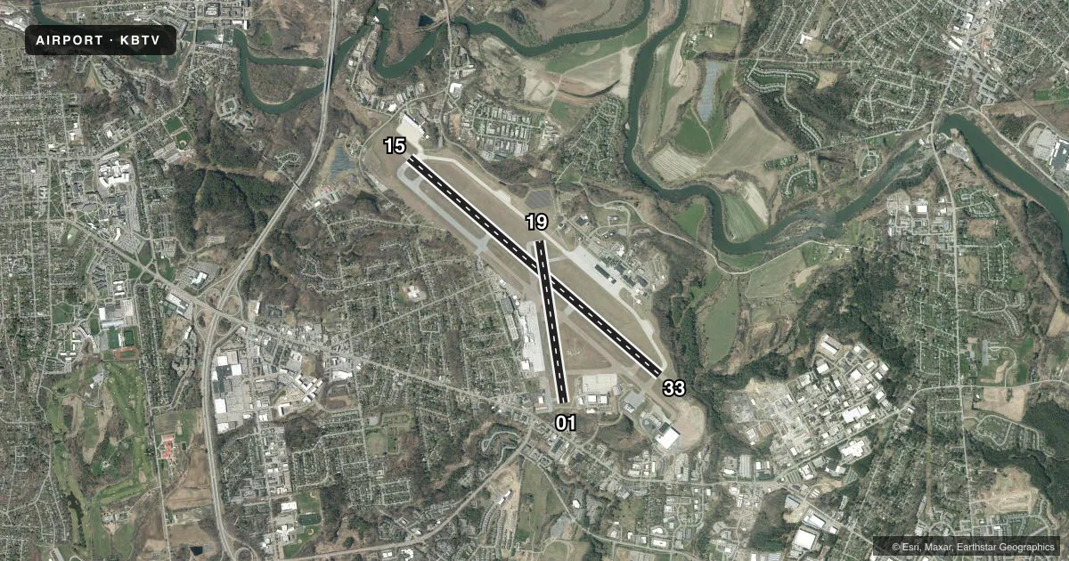
Runways & pattern
Full pagePattern entry · RWY 33
LEFT TRAFFIC| Runway | Heading (°M) | Length | Surface | Traffic |
|---|---|---|---|---|
| 15/33Favored | 116° / 296° | 8,319 ft | ASPH-CONC | Standard L |
| 01/19 | 336° / 156° | 4,112 ft | ASPH | Standard L |
Runway end performance
| End | TORA | TODA | ASDA | LDA | VGSI | Approach lights | Obstruction |
|---|---|---|---|---|---|---|---|
| 15 | 7,820' | 7,820' | 7,820' | 7,820' | PAPI 4-box right(3°) | MALSR | 51', trees, 1930' from thr, 705' R of cntrln, slope 33 |
| 33 | 8,320' | 8,320' | 8,320' | 7,820' | PAPI 4-box right(3.2°) | MALSF | 75', trees, 1975' from thr, 800' R of cntrln, slope 23 |
| 01 | 3,611' | 3,611' | 3,611' | 3,386' | PAPI 4-box left(4°) | — | 63', tree, 1290' from thr, 25' R of cntrln, slope 17 |
| 19 | 4,111' | 4,111' | 4,111' | 3,386' | PAPI 4-box right(3.5°) | — | — |
Declared distances in feet. TORA = takeoff run available, TODA = takeoff distance, ASDA = accelerate-stop, LDA = landing distance.
Airport sketch
Runways drawn to scale from FAA survey coordinates, rendered over satellite imagery. Not for navigation.
Approaches & charts
ILS · 2
Services on the field
Fuel grades, oxygen, maintenance, ramp storage and lighting — as declared to the FAA by the airport operator.
Fuel & services
- Fuel
- 100LLA
- Oxygen (bottled)
- High pressure
- Oxygen (bulk)
- High pressure
- Airframe repair
- Major
- Power plant repair
- Major
- Other services
- AFRT,AMB,AVNCS,CARGO,CHTR,INSTR,RNTL
Ramp & ground
- Transient storage
- Tie-down
- Hangar
- Landing fee
- Yes
- Customs
- Available
- Lighting schedule
- SEE RMK
- Beacon schedule
- SS-SR
- Beacon
- White / Green (civil land)(WG)
- Wind indicator
- Lighted
- Segmented circle
- No
Fuel & FBOs
Cheapest 100LL and Jet A on the field and nearby. Always confirm with the FBO before taxi.
Airport notes
Surface conditions, obstructions, local procedures, lighting outages and other notes published with each FAA cycle.
General notes
- CTN: GENERATING PLANT 2 NM FROM AER 15 PRODUCES STEAM WHICH MAY OBSC VSBTY ON FNA.
- ACR RAMP NOT AVBL FOR PVT & CHTR ACFT.
- BIRDS & DEER ON & INVOF ARPT.
- TWYS D, E, F, N, ANG & RNG RAMPS HAVE UNCONTROLLED VEHICLES & ACFT.
- FIGHTER ACFT RSTRD TO TKOF WINDOW OF 0830-2230 MON-SAT; 1200-2230 SUN.
- TWY L CLSD TO ACFT OVR 60000 LBS.
- ANG: NON-STD TWY LGTS ON TWY E.
- TWYS D, E, F, N CLSD TO CIVILIAN OPS.
- SERVICE-A-GEAR: TYPE H/BAK-12A(B) AER 33 LCTD 1000 FT FM DTHR. TYPE H/BAK 12A(B) CABLE RAISED BY TWR ON PILOT REQ ONLY. RWY 15 & RWY 33 A-G HOUSINGS ARE NON-FRANGIBLE (26 IN ABV GRD LEVEL) LCTD 250 FT FM RWY CNTLN.
- ANG: OPR 1030-2100Z++ WKDAYS, EXC HOL, CLSD SAT-MON. PPR FOR FUEL/PRKG, CTC ANG OPS DSN 220-5213/5920/5267 C802-660-5213. ALL TSNT ACFT ENR ETHAN ALLEN TRNG SITE AND R-6501A MUST STOP AT AASF FOR RQRD SAFETY BRIEF.
- TWY M AVBL FOR SEASONAL USE, CLSD DRG WINTER MONTHS.
- FIGHTER ACFT: NO LOW APCHS. ALL OTHER MIL ACFT LTD TO TWO PRACTICE APCHS. DO NOT FLY OVER HOSPITAL APRXLY 1.5 NM WEST OF RWY 15 APCH END.
- TWY A BTN TWY G & TWY C CLSD TO ACFT WINGSPAN MORE THAN 118 FT EXC 1 HR PPR 802-316-6014 DLY.
- FBO CLSD 0200-0900 DLY, EXC 1 HR PPR 802-863-3626.
- COLD TEMPERATURE AIRPORT. ALTITUDE CORRECTION REQUIRED AT OR BELOW -9C.
- ARFF AVBL 24 HRS.
- CAUTION: PHASE II WILDLIFE ACTVY DURG MIGRATION, MAR-MAY & AUG15-NOV15.
- FOR CD IF TWR CLSD & UNA TO CTC FSS FREQ, CTC BOSTON ARTCC AT 603-879-6859.
- BETA HELIPAD PVT USE ONLY.
- TWY G BTWN J & VALLEY RAMP CLSD TO ACFT WINGSPAN GTR THAN 156 FT.
- TWY K CLSD TO ACFT WINGSPAN MORE THAN 49 FT AND ACFT MORE THAN 12500 LB.
Lighting notes
- DUSK-DAWN. ACTVT MALSR RWY 15; MALSF RWY 33; PAPI RWY 01 & 15; MIRL RWY 01/19; HIRL RWY 15/33; ALL TWYS - CTAF. PAPI RWY 19 & 33 OPR CONSLY.
Runway surface & condition
- 01/19SOUTH OF RWY 15/33 INTXN TO TWY C, SW 100 DTW 355; SOUTH OF TWY C INTXN TO SOUTH END OF RWY, SW 30 DW 60.
- 01/19PCR VALUE: 700/F/C/X/T
- 15/33PCR VALUE: 751/R/C/W/T
Approach & departure obstructions
- 0120:1 TO DTHR.
- 3330:1 TO DTHR.
Arresting gear
- 15_MA-1ATYPE H/BAK-12A (B) 1499 FT.
- 33_BAK-12TYPE H/BAK-12A (B) 1500 FT.
Other notes
- EXISTED PRIOR TO 1959.
- FEE FOR ITNRNT ACFT GTR THAN 6000 LBS.
VFR map & nearby airports
VFR sectional. Tap any ICAO chip to open that airport.
Key facts · KBTV
Answer card- ICAO
- KBTV
- Name
- PATRICK LEAHY BURLINGTON INTL
- Location
- BURLINGTON, VERMONT
- Elevation
- 334.6 ft MSL
- Traffic pattern altitude
- 1,334.6 ft MSL (1,000 AGL)
- Control tower
- Towered · 0530-0000
- Total runways
- 2
- Longest runway
- 15/33 · 8,319 ft
- Published ILS approaches
- 2
- Published frequencies
- 17
- Magnetic variation
- 15°
- Current flight rules
- VFR
- Current wind
- 260° at 4 kt
- Favored runway now
- RWY 33
Patrick Leahy Burlington Intl is in Burlington, Vermont. The field elevation is 334.6 ft MSL. It has 2 asphalt runways. The longest is 8,319 ft on 15/33. The airport is towered. Tower hours are 0530-0000. Two ILS approaches are published for runway ends 15 and 33.
Pattern altitude is not published in the facts. Use the standard 1,000 ft AGL for light piston aircraft unless ATC or the current Chart Supplement says otherwise. Heritage Aviation is on the field. It carries 100LL, Jet A and Jet A Prist. For current ramp, parking, or fuel availability details, call the FBO directly.
This is a cold temperature airport. Altitude correction is required at or below minus 9 degrees Celsius. The field also has a few items that matter on rollout and taxi. Taxiway K is limited to smaller aircraft. Taxiway M is seasonal. There is also a steam source about 2 NM from the aerodrome off the 15 side that can blur the final approach picture. Runway 15 has MALSR. Runway 33 has MALSF. PAPI is available on 01, 15, 19 and 33. The airport sits in Class C airspace, so plan to work the tower and approach frequencies on arrival.