METAR & TAF KBDR
Current METAR
Observed 18:52Z
KBDR 271852Z 13008KT 10SM CLR 26/18 A2981 RMK AO2 LTG DSNT SW SLP094 CB DSNT S NOVG E T02560183
- Wind
- 130° @ 8 kt
- Visibility
- 10 SM
- Temp / Dew
- 26°C / 18°C
- Altimeter
- 29.81 inHg
- Clouds
- CLR
- Density alt
- 1,467 ft
- Ceiling
- Unlimited
- Rules
- VFR
Airport info & contacts
Manager on record, flight service, ARTCC, attendance schedule and pattern altitude — published by the FAA and refreshed every 28 days.
Location
- From city
- 3 NM SE
- VFR sectional
- NEW YORK
- ARTCC
- ZNY · NEW YORK
- NOTAM facility
- BDR (NOTAM-D)
Airport manager
- Name
- LISA TRACHTENBURG
- Phone
- 203-576-8163
- Address
- 1000 GREAT MEADOW RD, STRATFORD CT 06497
Flight service · Hours
- FSS BDR
- BRIDGEPORT1-800-WX-BRIEF
- Attendance
- 0600-2400
Frequencies
Tap any row to copy the frequency to your clipboard.
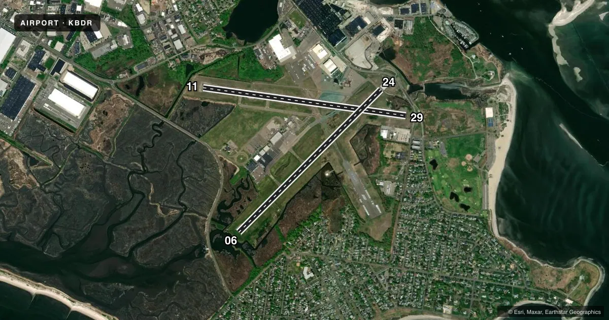
Runways & pattern
Full pagePattern entry · RWY 11
LEFT TRAFFIC| Runway | Heading (°M) | Length | Surface | Traffic |
|---|---|---|---|---|
| 11/29Favored | 85° / 265° | 4,759 ft | ASPH | 29 R |
| 06/24 | 32° / 212° | 4,677 ft | ASPH | Standard L |
Runway end performance
| End | TORA | TODA | ASDA | LDA | VGSI | Approach lights | Obstruction |
|---|---|---|---|---|---|---|---|
| 11 | 4,759' | 4,759' | 4,759' | 4,759' | PAPI 4-box right(3.5°) | — | 35', trees, 500' from thr, 120' R of cntrln, slope 8 |
| 29 | 4,759' | 4,759' | 4,759' | 4,395' | PAPI 4-box left(3°) | — | 15', road, 200' from thr, 0' R of cntrln, slope 0 |
| 06 | 4,677' | 4,677' | 4,677' | 4,677' | PAPI 4-box right(3°) | — | 19', road, 480' from thr, 525' R of cntrln, slope 14 |
| 24 | 4,677' | 4,677' | 4,677' | 4,357' | PAPI 4-box left(3°) | — | 19', road, 200' from thr, 150' R of cntrln, slope 1 |
Declared distances in feet. TORA = takeoff run available, TODA = takeoff distance, ASDA = accelerate-stop, LDA = landing distance.
Airport sketch
Runways drawn to scale from FAA survey coordinates, rendered over satellite imagery. Not for navigation.
Approaches & charts
ILS · 1
Services on the field
Fuel grades, oxygen, maintenance, ramp storage and lighting — as declared to the FAA by the airport operator.
Fuel & services
- Fuel
- 100LLA
- Oxygen (bottled)
- HIGH/LOW
- Airframe repair
- Major
- Power plant repair
- Major
- Other services
- AFRT,AMB,AVNCS,CHTR,INSTR,RNTL,SALES
Ramp & ground
- Transient storage
- Tie-down
- Hangar
- Landing fee
- Yes
- Customs
- Not available
- Lighting schedule
- SEE RMK
- Beacon schedule
- SS-SR
- Beacon
- White / Green (civil land)(WG)
- Wind indicator
- Lighted
- Segmented circle
- Yes
Fuel & FBOs
Cheapest 100LL and Jet A on the field and nearby. Always confirm with the FBO before taxi.
Airport notes
Surface conditions, obstructions, local procedures, lighting outages and other notes published with each FAA cycle.
General notes
- EXTSV HOP BLW 10000 FT 5-15 MI NW THRU NE, FOR TFC INFO WHEN INVOF ARPT CTC SIKORSKY OPS ON 133.6/305.8 (0700-1630).
- WHEN WINDS ARE LESS THAN 5 KTS RQSTD USE OF RWY 11 OR 29.
- BIRDS & WILDLIFE FQTLY ON & INVOF ARPT.
- THERE MAY BE STANDING WATER ADJ TO ALL SFCS.
- AVOID OVERFLYING RESL AREAS NE & SE OF ARPT. DEPARTING RWY 24 AVOID TURNS TIL 1/2 MILE BYD SHORELINE.
- WHEN ATCT CLSD ALL ENG RUNUPS ARE PROHIBITED. HWVR, IF AN ACFT RQRS NIGHTTIME ENG MAINT, PPR FM AMGR IS RQRD AND RUNUPS ARE TO BE PERFORMED ON TWY G BTWN J & K. PILOTS ARE ADZD TO USE CARE PSNG THEIR ACFT TO PREVENT DMG FM PROP WASH TO AFLD SIGN.
- UNEVEN SFCS RWY 29 SAFETY AREA APCH END LEFT SIDE.
- POLE 120 FT .75 NM S OF ARPT UNLGTD.
- RWY 29 CLSD TO TKOF ACFT MORE THAN 45000 LB EXC 30 MIN PPR 203-576-7497.
- FOR CD WHEN ATCT CLSD CTC NEW YORK APCH AT 516-683-2449 OR 124.075
Lighting notes
- WHEN ATCT CLSD, ACTVT REIL RWY 06 & 24, 11 & 29; PAPI RWY 06, 11 & 29; HIRL RWY 06/24 & 11/29 - CTAF.
Runway surface & condition
- 06/24PCR VALUE: 278/F/B/X/U
- 11/29PCR VALUE: 278/F/B/X/U
- 06/24RWY 06/24 NOT AVBL FOR PART 121/PART 380 OPS WITH SKED PAX CARRYING OPS MORE THAN 9 PAX SEATS AND NON-SKED PAX CARRYING OPS MORE THAN 30 PAX SEATS. 90 DAY PPR FOR UNSKED ACR OPS GTR THAN 30 PAX SEATS - CALL AMGR.
- 11/29RWY 11/29 NOT AVBL FOR PART 121/PART 380 OPS WITH SKED PAX CARRYING OPS MORE THAN 9 PAX SEATS AND NON-SKED PAX CARRYING OPS MORE THAN 30 PAX SEATS. 90 DAY PPR FOR UNSKED ACR OPS GTR THAN 30 PAX SEATS - CALL AMGR.
Approach & departure obstructions
- 24APCH RATIO 34:1 TO DTHR.
- 29APCH RATIO 20:1 TO DTHR.
Other notes
- EXISTED PRIOR TO 1959.
- PRKG FEE ALL ACFT AFT 2 HRS. LDG FEE ALL ACFT EXC SOLO STUDENTS.
- SNGL ENG ACFT 1000 FT AGL; ALL OTHERS 1500 FT AGL.
VFR map & nearby airports
VFR sectional. Tap any ICAO chip to open that airport.
Key facts · KBDR
Answer card- ICAO
- KBDR
- Name
- BRIDGEPORT/SIKORSKY
- Location
- BRIDGEPORT, CONNECTICUT
- Elevation
- 8.5 ft MSL
- Traffic pattern altitude
- 1,008.5 ft MSL (1,000 AGL)
- Control tower
- Towered · 0630-2200
- Total runways
- 2
- Longest runway
- 11/29 · 4,759 ft
- Published ILS approaches
- 1
- Published frequencies
- 11
- Magnetic variation
- 13°
- Current flight rules
- VFR
- Current wind
- 130° at 8 kt
- Favored runway now
- RWY 11
Bridgeport/Sikorsky is in Bridgeport, Connecticut. The field elevation is 8.5 ft MSL. It has two asphalt runways. The longest is 4,759 ft. The tower is open daily from 0630 to 2200. One ILS approach is published for runway 06.
Pattern altitude is not published in the facts. For planning, use 1,000 ft AGL for single-engine aircraft. Use 1,500 ft AGL for all others, which is the published traffic pattern guidance here. Atlantic Aviation is on the field with 100LL and Jet A. Three Wing Aviation Group is also on the field with 100LL, Jet A and Jet A Prist. Birds and wildlife are frequently present on and near the airport. That matters on departure and arrival.
There are a few local items to brief before you go. Winds under 5 knots bring a runway preference for 11 or 29. Avoid overflying the residential areas northeast and southeast of the airport. When departing runway 24, stay straight until you are one half mile beyond the shoreline. Runway 29 has an uneven safety area on the left side near the approach end. This is a busy field with extensive helicopter traffic below 10,000 ft from the northwest through northeast. If you need traffic information near the airport, contact Sikorsky operations on 133.6 or 305.8 between 0700 and 1630.