METAR & TAF H34
H34 does not publish a METAR.
Showing the nearest reporting station: KASG (SPRINGDALE MUNI) · 18.6 NM away. Conditions at H34 may differ.
METAR · KASG
Observed 14:48Z
KASG 281448Z 26007KT 10SM CLR 32/26 A2994
- Wind
- 260° @ 7 kt
- Visibility
- 10 SM
- Temp / Dew
- 32°C / 26°C
- Altimeter
- 29.94 inHg
- Clouds
- CLR
- Density alt
- 4,183 ft
- Ceiling
- Unlimited
- Rules
- VFR
Airport info & contacts
Manager on record, flight service, ARTCC, attendance schedule and pattern altitude — published by the FAA and refreshed every 28 days.
Location
- From city
- 2 NM SW
- VFR sectional
- KANSAS CITY
- ARTCC
- ZME · MEMPHIS
- NOTAM facility
- JBR (NOTAM-D)
Airport manager
- Name
- CHARLES COGER
- Phone
- 479-738-7287
- Address
- PO BOX 844, HUNTSVILLE AR 72740
Flight service · Hours
- FSS JBR
- JONESBORO1-800-WX-BRIEF
- Attendance
- Unattended
Frequencies
Tap any row to copy the frequency to your clipboard.
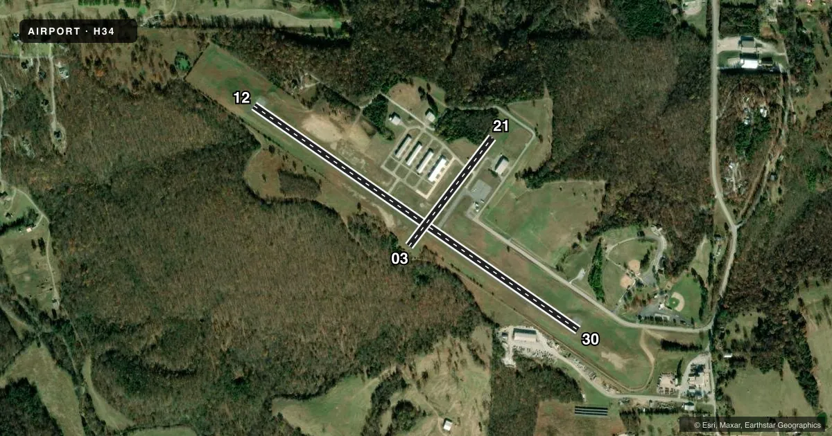
Runways & pattern
Full pagePattern entry · RWY 21
LEFT TRAFFICAirport sketch
Runways drawn to scale from FAA survey coordinates, rendered over satellite imagery. Not for navigation.
Approaches & charts
Services on the field
Fuel grades, oxygen, maintenance, ramp storage and lighting — as declared to the FAA by the airport operator.
Fuel & services
- Fuel
- 100LL
- Other services
- INSTR
Ramp & ground
- Transient storage
- Tie-down
- Landing fee
- No fee published
- Lighting schedule
- SEE RMK
- Beacon schedule
- SS-SR
- Beacon
- White / Green (civil land)(WG)
- Wind indicator
- Lighted
- Segmented circle
- No
Fuel & FBOs
Cheapest 100LL and Jet A on the field and nearby. Always confirm with the FBO before taxi.
Airport notes
Surface conditions, obstructions, local procedures, lighting outages and other notes published with each FAA cycle.
General notes
- ULTRALIGHT ACTIVITY ON & INVOF ARPT.
- FOR CD CTC RAZORBACK APCH 479-649-2416, WHEN APCH CLSD CTC MEMPHIS ARTCC AT 901-368-8453/8449.
Lighting notes
- ACTVT MIRL RY 12/30 - CTAF.
Fuel notes
- 100LLSELF SERVICE FUEL AVBL 24 HRS WITH CREDIT CARD.
Other notes
- 03/21STEEP DROP OFF AT RY ENDS.
VFR map & nearby airports
VFR sectional. Tap any ICAO chip to open that airport.
Key facts · H34
Answer card- ICAO
- H34
- Name
- HUNTSVILLE MUNI
- Location
- HUNTSVILLE, ARKANSAS
- Elevation
- 1,747.9 ft MSL
- Traffic pattern altitude
- 2,747.9 ft MSL (1,000 AGL)
- Control tower
- Non-towered (use CTAF)
- Total runways
- 2
- Longest runway
- 12/30 · 3,601 ft
- Published ILS approaches
- 0
- Published frequencies
- 4
- Magnetic variation
- 1°
- Current flight rules
- VFR
- Current wind
- 260° at 7 kt
- Favored runway now
- RWY 21
Huntsville Muni sits in Huntsville, Arkansas at 1,747.9 ft MSL. It has two runways. The longest is 12/30 at 3,601 ft asphalt. Runway 03/21 is 1,250 ft turf. There is no control tower. Pattern altitude is not published, so use the standard 1,000 ft AGL unless the current Chart Supplement says otherwise.
No ILS approaches are published here. For IFR work, plan with the current Chart Supplement and get the latest approach and clearance details before launch. Published remarks say 100LL self-serve is available 24 hours with credit card. The on-field FBO is Huntsville Municipal Airport. It carries AVGAS 100LL.
Runway 12/30 has medium intensity lights that are activated by CTAF. That matters after dark because you will need to key the lights from the pattern. Runway 03/21 has a steep drop-off at the ends, so treat that turf strip with extra caution on rollout and takeoff. Ultralight activity also occurs on and near the airport. This is a non-towered field with Razorback Approach handling clearances when available. If approach is closed, the published remarks direct pilots to Memphis ARTCC. For a first visit, brief the elevation, the turf strip, the drop-offs and the mixed traffic before you arrive.