METAR & TAF H17
H17 does not publish a METAR.
Showing the nearest reporting station: KLBO (FLOYD W JONES LEBANON) · 20.7 NM away. Conditions at H17 may differ.
METAR · KLBO
Observed 17:15Z
KLBO 121715Z AUTO 14003KT 10SM CLR 26/11 A3008 RMK AO2
- Wind
- 140° @ 3 kt
- Visibility
- 10 SM
- Temp / Dew
- 26°C / 11°C
- Altimeter
- 30.08 inHg
- Clouds
- CLR
- Density alt
- 2,553 ft
- Ceiling
- Unlimited
- Rules
- VFR
Airport info & contacts
Manager on record, flight service, ARTCC, attendance schedule and pattern altitude — published by the FAA and refreshed every 28 days.
Location
- From city
- 1 NM N
- VFR sectional
- KANSAS CITY
- ARTCC
- ZKC · KANSAS CITY
- NOTAM facility
- COU (NOTAM-D)
Airport manager
- Name
- JEFFERY LILLEY
- Phone
- 417-839-9306
- Address
- 18 CH GROVE RD, BUFFALO MO 65622
Flight service · Hours
- FSS COU
- COLUMBIA1-800-WX-BRIEF
- Attendance
- Unattended
Frequencies
Tap any row to copy the frequency to your clipboard.
Runways & pattern
Full pagePattern entry · RWY 22
LEFT TRAFFICRunway end performance
| End | TORA | TODA | ASDA | LDA | VGSI | Approach lights | Obstruction |
|---|---|---|---|---|---|---|---|
| 04 | — | — | — | — | — | — | 47', tree, 310' from thr, 75' R of cntrln, slope 2 |
| 22 | — | — | — | — | — | — | 49', tree, 270' from thr, 115' R of cntrln, slope 1 |
Declared distances in feet. TORA = takeoff run available, TODA = takeoff distance, ASDA = accelerate-stop, LDA = landing distance.
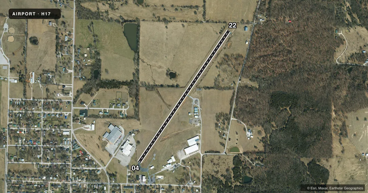
Airport sketch
Runways drawn to scale from FAA survey coordinates, rendered over satellite imagery. Not for navigation.
Approaches & charts
Services on the field
Fuel grades, oxygen, maintenance, ramp storage and lighting — as declared to the FAA by the airport operator.
Fuel & services
- Fuel
- 100LL
- Oxygen (bottled)
- Not available
- Oxygen (bulk)
- Not available
- Other services
- INSTR
Ramp & ground
- Transient storage
- Tie-down
- Landing fee
- No fee published
- Customs
- Not available
- Lighting schedule
- SEE RMK
- Beacon schedule
- SS-SR
- Beacon
- White / Green (civil land)(WG)
- Wind indicator
- Lighted
- Segmented circle
- Yes
Fuel & FBOs
Cheapest 100LL and Jet A on the field and nearby. Always confirm with the FBO before taxi.
Airport notes
Surface conditions, obstructions, local procedures, lighting outages and other notes published with each FAA cycle.
General notes
- ULTRALIGHT ACFT ON & INVOF ARPT.
- WILDLIFE ON AND INVOF ARPT.
- INSUF RWY SAFETY AREA LEN BYD EACH RWY END; FENCES, BRUSH, TREES.
- APCH SLP 8 TO 1 TO HELIPAD FROM NORTHEAST; ARPT BCN 260 FT SOUTH OF HELIPAD, 5 TO 1 APCH SLP.
- FOR CD CTC SPRINGFIELD APCH AT 417-868-5620/5619.
Lighting notes
- ACTVT LIRL RY 04/22 & PERIMETER LGTS - CTAF.
Runway surface & condition
- H15 LANDING DIRECTION LIGHTS EXTENDING NORTHEAST.
- 04/22WIDTH VARIANCE 50-52 FT.
Approach & departure obstructions
- 04RWY 04 +1-19 FT TREES, FENCES, 35-200 FT FM RWY END, L/R.
- 22RWY 22 +1-35 FT FENCES, TREES & BRUSH 0-200 FT FM RY END, L/R.
- 04RWY 04 APCH SLP 12:1 TO DSPLCD THR; +1-60 FT TREES & TIED DOWN ACFT; 0-650 FT FM RWY END, L & R; DSPLCD THR 5 FT LWR THAN RWY END.
Other notes
- MANAGERALT. PHONE 417-733-0030.
VFR map & nearby airports
VFR sectional. Tap any ICAO chip to open that airport.
Key facts · H17
Answer card- ICAO
- H17
- Name
- BUFFALO MUNI
- Location
- BUFFALO, MISSOURI
- Elevation
- 1,154 ft MSL
- Traffic pattern altitude
- 2,154 ft MSL (1,000 AGL)
- Control tower
- Non-towered (use CTAF)
- Total runways
- 1
- Longest runway
- 04/22 · 3,220 ft
- Published ILS approaches
- 0
- Published frequencies
- 1
- Magnetic variation
- 4°
- Current flight rules
- VFR
- Current wind
- 140° at 3 kt
- Favored runway now
- RWY 22
Buffalo Muni is in Buffalo, Missouri. The field elevation is 1,154 ft MSL. It has one runway, 04/22, which is 3,220 ft long and asphalt. There is no control tower. CTAF is 122.9.
No ILS approaches are published here. The pattern altitude is not published. Use the standard 1,000 ft AGL for light piston traffic unless the current Chart Supplement says otherwise. The on-field FBO is Buffalo Municipal Airport. It carries 100LL. Call (417) 733-0030 for current service details.
This field has a few items a first-time pilot should plan for. Low intensity runway lights are active on 04/22. Perimeter lights are controlled by CTAF. Runway 04 has displaced-threshold and obstacle notes. Trees, fences, tied-down aircraft, brush and runway safety area limits are all called out near the ends. Wildlife and ultralight traffic are also reported in the airport area. The airport is not towered. Make your calls early and stay alert on CTAF. For clearance delivery, Springfield Approach is listed in the remarks. Check the current Chart Supplement before you go if you need the latest operational notes.