METAR & TAF TJPS
Current METAR
Observed 12:15Z
TJPS 271215Z AUTO 06006KT 10SM CLR 30/21 A3000
- Wind
- 060° @ 6 kt
- Visibility
- 10 SM
- Temp / Dew
- 30°C / 21°C
- Altimeter
- 30.00 inHg
- Clouds
- CLR
- Density alt
- 1,746 ft
- Ceiling
- Unlimited
- Rules
- VFR
Airport info & contacts
Manager on record, flight service, ARTCC, attendance schedule and pattern altitude — published by the FAA and refreshed every 28 days.
Location
- From city
- 3 NM E
- VFR sectional
- PUERTO RICO-VIRGIN ISLANDS
- ARTCC
- ZSU · SAN JUAN
- NOTAM facility
- TJPS (NOTAM-D)
Airport manager
- Name
- WILLIAM FEBLES
- Phone
- 787-729-8715
- Address
- P.O. BOX 670, MERCEDITA PR 00715
Flight service · Hours
- FSS SJU
- SAN JUAN1-800-WX-BRIEF
- Attendance
- ALL
Frequencies
Tap any row to copy the frequency to your clipboard.
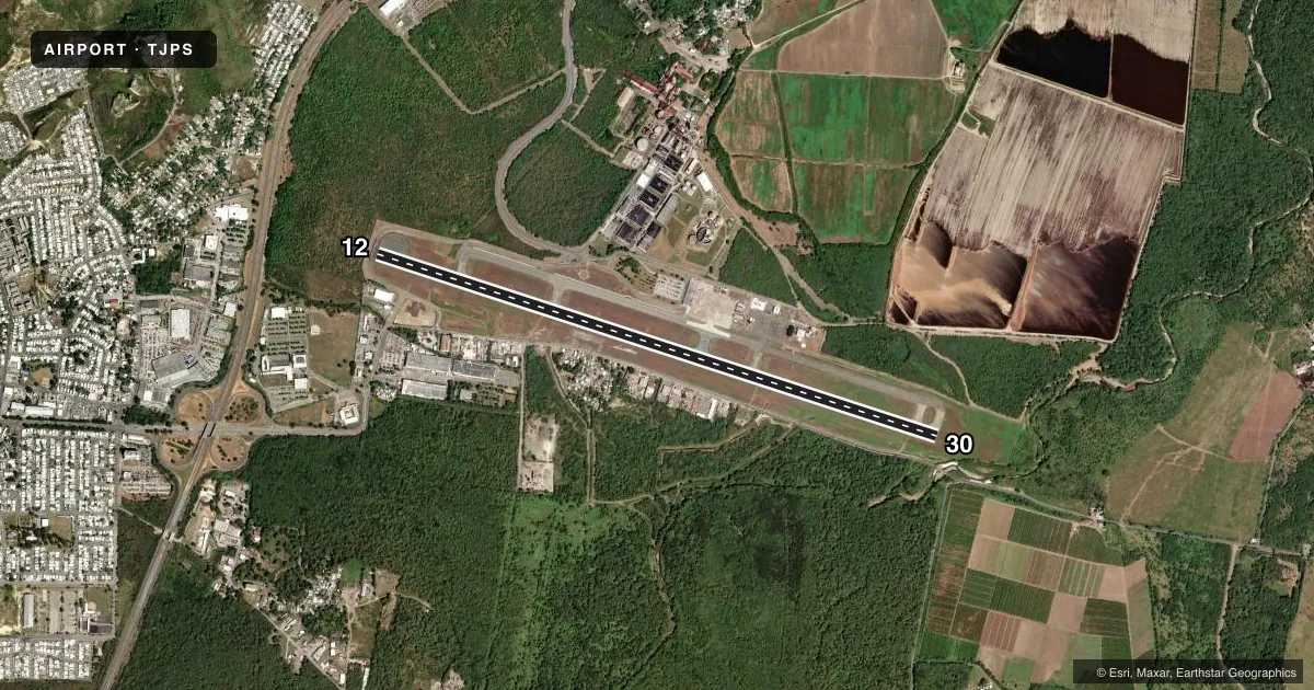
Runways & pattern
Full pagePattern entry · RWY 12
RIGHT TRAFFICRunway end performance
| End | TORA | TODA | ASDA | LDA | VGSI | Approach lights | Obstruction |
|---|---|---|---|---|---|---|---|
| 12 | — | — | — | — | — | — | 295', pline, 4155' from thr, 800' R of cntrln, slope 13 |
| 30 | — | — | — | — | PAPI 4-box right(3°) | — | 41', trees, 1570' from thr, 75' R of cntrln, slope 33 |
Declared distances in feet. TORA = takeoff run available, TODA = takeoff distance, ASDA = accelerate-stop, LDA = landing distance.
Airport sketch
Runways drawn to scale from FAA survey coordinates, rendered over satellite imagery. Not for navigation.
Approaches & charts
Services on the field
Fuel grades, oxygen, maintenance, ramp storage and lighting — as declared to the FAA by the airport operator.
Fuel & services
- Fuel
- 100LLA
- Oxygen (bottled)
- Not available
- Oxygen (bulk)
- Not available
- Airframe repair
- Minor
- Power plant repair
- Minor
- Other services
- AGRI,CARGO,CHTR,INSTR,RNTL,TOW
Ramp & ground
- Transient storage
- Tie-down
- Hangar
- Landing fee
- Yes
- Customs
- Not available
- Lighting schedule
- SEE RMK
- Beacon schedule
- SS-SR
- Beacon
- White / Green (civil land)(WG)
- Wind indicator
- Lighted
- Segmented circle
- Yes
Fuel & FBOs
Cheapest 100LL and Jet A on the field and nearby. Always confirm with the FBO before taxi.
Airport notes
Surface conditions, obstructions, local procedures, lighting outages and other notes published with each FAA cycle.
General notes
- CUSTOMS AVAILABLE 1200Z TO 2100Z MON-FRI.
- FOR CD IF FREQ ARE OTS CTC SAN JUAN CERAP AT 787-253-8664/8665.
Lighting notes
- HIRL RWY 12/30 PRESET MED INTST DUSK-2200; TO INCR INTST & ACTVT HIRL RWY 12/30 AND REIL RWY 12 AFTER 2200 - UNICOM 122.70. PAPI RWY 30 OPER CONT.
Runway surface & condition
- 12/30PCR VALUE: 400/F/C/X/T
Approach & departure obstructions
- 12APCH RATIO 16:1 TO DSPLCD THR.
Other notes
- PPR 24 HRS FOR INDEX C & ABOVE UNSKED ACR OPNS WITH MORE THAN 30 PSGR SEATS CALL AMGR 787-842-6292.
- FEE FOR OTHER THAN HOME BASED ACFT.
- MANAGEREXT 5100 OR 5101
- 12/30RWY 30, LAST 1100 FT NOT GROOVED.
VFR map & nearby airports
VFR sectional. Tap any ICAO chip to open that airport.
Key facts · TJPS
Answer card- ICAO
- TJPS
- Name
- MERCEDITA
- Location
- PONCE, PUERTO RICO
- Elevation
- 36.7 ft MSL
- Traffic pattern altitude
- 1,036.7 ft MSL (1,000 AGL)
- Control tower
- Non-towered (use CTAF)
- Total runways
- 1
- Longest runway
- 12/30 · 8,002 ft
- Published ILS approaches
- 0
- Published frequencies
- 2
- Magnetic variation
- 11°
- Current flight rules
- VFR
- Current wind
- 060° at 6 kt
- Favored runway now
- RWY 12
Mercedita sits in Ponce, Puerto Rico. Field elevation is 36.7 ft MSL. The airport has one runway. Runway 12/30 is 8,002 ft long on asphalt. There is no control tower. CTAF and UNICOM are both 122.7. No ILS approaches are published here.
Pattern altitude is not published. Use the standard 1,000 ft AGL pattern unless the current Chart Supplement or local procedures say otherwise. That puts the light aircraft pattern near 1,037 ft MSL based on field elevation, but verify before flight if you need an exact published value. The runway lighting note matters here. Runway 12/30 lights sit at medium intensity from dusk to 2200. After 2200, use UNICOM 122.70 to raise the intensity and activate the runway end identifier lights for runway 12. The PAPI for runway 30 operates continuously.
No on-field FBOs are listed in the facts, so call the airport operator or the field directly before arrival if you need ground support or fuel status. The published remarks also note a landing fee for aircraft other than home based aircraft. There is a prior permission requirement for Index C and above unscheduled aircraft operations with more than 30 passenger seats. Customs is available from 1200Z to 2100Z Monday through Friday. Runway 30 has the last 1,100 ft not grooved. The pavement rating is 400/F/C/X/T. For clearance delivery if frequencies are out of service, contact San Juan CERAP.