METAR & TAF PASD
Current METAR
Observed 16:23Z
PASD 281623Z 19013G21KT 8SM -RA SCT013 BKN018 OVC030 09/07 A3023 RMK AO2 RAB01 PNO $
- Wind
- 190° @ 13G21 kt
- Visibility
- 8 SM
- Temp / Dew
- 9°C / 7°C
- Altimeter
- 30.23 inHg
- Clouds
- OVC
- Density alt
- -1,075 ft
- Ceiling
- 1,800 ft AGL
- Rules
- MVFR
Airport info & contacts
Manager on record, flight service, ARTCC, attendance schedule and pattern altitude — published by the FAA and refreshed every 28 days.
Location
- From city
- 2 NM SW
- VFR sectional
- COLD BAY
- ARTCC
- ZAN · ANCHORAGE
- NOTAM facility
- SDP (NOTAM-D)
Airport manager
- Name
- RUSSELL RUTA
- Phone
- 907-386-6106
- Address
- BOX 97, COLD BAY AK 99571
Flight service · Hours
- FSS CDB
- COLD BAY907-532-24661-800-478-7250
- Attendance
- JAN - DEC · MON - SAT · 0800-1700
Frequencies
Tap any row to copy the frequency to your clipboard.
Runways & pattern
Full pagePattern entry · RWY 14
RIGHT TRAFFICRunway end performance
| End | TORA | TODA | ASDA | LDA | VGSI | Approach lights | Obstruction |
|---|---|---|---|---|---|---|---|
| 14 | 4,637' | 5,213' | 4,637' | 4,099' | PAPI 4-box left(3.6°) | — | — |
| 32 | 4,675' | 5,213' | 4,675' | 4,099' | PAPI 4-box right(3.6°) | — | — |
Declared distances in feet. TORA = takeoff run available, TODA = takeoff distance, ASDA = accelerate-stop, LDA = landing distance.
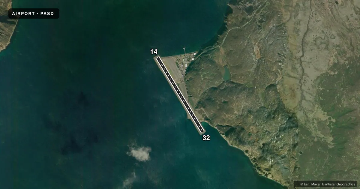
Airport sketch
Runways drawn to scale from FAA survey coordinates, rendered over satellite imagery. Not for navigation.
Approaches & charts
Services on the field
Fuel grades, oxygen, maintenance, ramp storage and lighting — as declared to the FAA by the airport operator.
Fuel & services
- Fuel
- A
Ramp & ground
- Transient storage
- Not published
- Landing fee
- Yes
- Customs
- Not available
- Lighting schedule
- SEE RMK
- Beacon schedule
- SEE RMK
- Beacon
- White / Green (civil land)(WG)
- Wind indicator
- Lighted
- Segmented circle
- Yes
Fuel & FBOs
Cheapest 100LL and Jet A on the field and nearby. Always confirm with the FBO before taxi.
Airport notes
Surface conditions, obstructions, local procedures, lighting outages and other notes published with each FAA cycle.
General notes
- BIRDS INVOF ARPT.
- 80-320 FT CLIFF E SIDE OF RWY; EXP TURB ON APCH RWY 32.
- SAND LRGR GRADATION THAN RECMD/SEE AC150/5200-30.
- SAND POINT WX 0800-1800 - 132.05 OR 907-383-2403.
Lighting notes
- ON CONSLY.
- ACTVT REIL RWY 14 & 32; PAPI RWY 14 & 32; MIRL RWY 14/32 - CTAF.
Fuel notes
- A0800-2000 - 907-383-2026; AFT HR CALL OUT FEE.
Runway surface & condition
- 14/32PCR VALUE: 1018/F/A/X/T
Other notes
- CLSD TO ACR MORE THAN 30 PAX SEATS EXC PPR IN WRITING - AMGR.
- OVR 6000 LB.
VFR map & nearby airports
VFR sectional. Tap any ICAO chip to open that airport.
Key facts · PASD
Answer card- ICAO
- PASD
- Name
- SAND POINT
- Location
- SAND POINT, ALASKA
- Elevation
- 23.6 ft MSL
- Traffic pattern altitude
- 1,023.6 ft MSL (1,000 AGL)
- Control tower
- Non-towered (use CTAF)
- Total runways
- 1
- Longest runway
- 14/32 · 5,213 ft
- Published ILS approaches
- 0
- Published frequencies
- 2
- Magnetic variation
- 11°
- Current flight rules
- MVFR
- Current wind
- 190° at 13 kt
- Favored runway now
- RWY 14
Sand Point Airport sits in Sand Point, Alaska. Field elevation is 23.6 ft MSL. The airport has one runway, 14/32, which is 5,213 ft long. There is no control tower. No ILS approaches are published. The pattern altitude is not published, so a light piston pilot should plan on the standard 1,000 ft AGL unless the current Chart Supplement says otherwise.
Runway lighting is pilot controlled through CTAF. Runway 14 and 32 have REILs and PAPI. The beacon is on continuously. Weather is available from 0800 to 1800 on 132.05 or by phone at 907-383-2403. There are birds in the area. The east side of the runway has an 80 to 320 ft cliff. Expect turbulence on approach to runway 32. Sand on the field has a larger gradation than recommended.
No on-field FBOs are listed. Fuel is available from 0800 to 2000 at 907-383-2026. After-hours call-out fees apply. The airport is closed to aircraft with more than 30 passenger seats except with prior written permission from the airport manager. There is also a landing fee for aircraft over 6,000 lb. Check the current FAA Chart Supplement for any local operating notes before you go.