METAR & TAF PAPE
Current METAR
Observed 16:56Z
PAPE 281656Z AUTO 23009G16KT 10SM BKN018 OVC025 09/06 A3024 RMK AO2 SLP237 T00940061
- Wind
- 230° @ 9G16 kt
- Visibility
- 10 SM
- Temp / Dew
- 9°C / 6°C
- Altimeter
- 30.24 inHg
- Clouds
- OVC
- Density alt
- -1,080 ft
- Ceiling
- 1,800 ft AGL
- Rules
- MVFR
Airport info & contacts
Manager on record, flight service, ARTCC, attendance schedule and pattern altitude — published by the FAA and refreshed every 28 days.
Location
- From city
- 1 NM SSW
- VFR sectional
- COLD BAY
- ARTCC
- ZAN · ANCHORAGE
- NOTAM facility
- ENA (NOTAM-D)
Airport manager
- Name
- FLOYD WILSON
- Phone
- 907-246-3325
- Address
- PO BOX 65, KING SALMON AK 99613
Flight service · Hours
- FSS CDB
- COLD BAY907-532-24661-800-478-7250
- Attendance
- Unattended
Frequencies
Tap any row to copy the frequency to your clipboard.
Runways & pattern
Full pagePattern entry · RWY 20
LEFT TRAFFICRunway end performance
| End | TORA | TODA | ASDA | LDA | VGSI | Approach lights | Obstruction |
|---|---|---|---|---|---|---|---|
| 02 | — | — | — | — | PAPI 4-box left(3.4°) | — | 227', hill, 5200' from thr, 1053' R of cntrln, slope 22 |
| 20 | — | — | — | — | — | — | 508', hill, 5500' from thr, 548' R of cntrln, slope 10 |
Declared distances in feet. TORA = takeoff run available, TODA = takeoff distance, ASDA = accelerate-stop, LDA = landing distance.
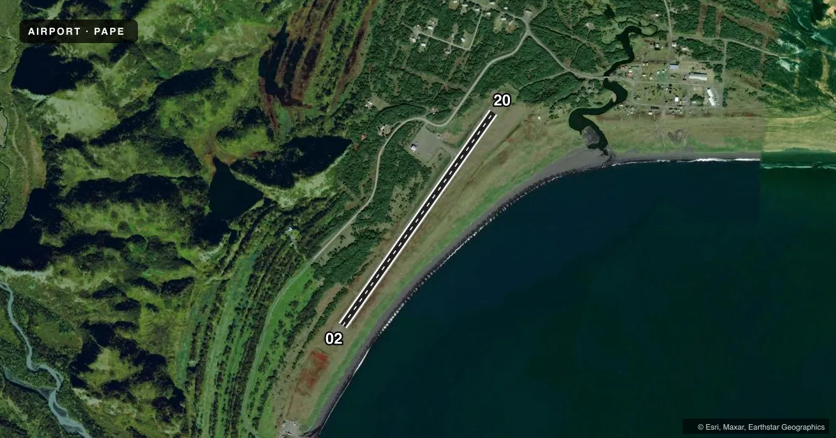
Airport sketch
Runways drawn to scale from FAA survey coordinates, rendered over satellite imagery. Not for navigation.
Approaches & charts
Services on the field
Fuel grades, oxygen, maintenance, ramp storage and lighting — as declared to the FAA by the airport operator.
Fuel & services
- Fuel
- Not available
- Oxygen (bottled)
- Not available
- Oxygen (bulk)
- Not available
- Airframe repair
- Not available
- Power plant repair
- Not available
Ramp & ground
- Transient storage
- Tie-down
- Landing fee
- No fee published
- Customs
- Not available
- Lighting schedule
- SEE RMK
- Beacon schedule
- SEE RMK
- Beacon
- White / Green (civil land)(WG)
- Wind indicator
- Lighted
- Segmented circle
- Yes
Fuel & FBOs
Cheapest 100LL and Jet A on the field and nearby. Always confirm with the FBO before taxi.
Airport notes
Surface conditions, obstructions, local procedures, lighting outages and other notes published with each FAA cycle.
General notes
- RWY COND NOT MONITORED; RCMD VISUAL INSPECTION PRIOR TO USING.
- WX CAMERA AVBL ON INTERNET AT HTTPS://WEATHERCAMS.FAA.GOV.
Lighting notes
- ACTVT ROTG BCN - CTAF.
- ACTVT REIL RWY 02; PAPI RWY 02; MIRL RWY 02/20 - CTAF.
Approach & departure obstructions
- 02250 FT HILL 1 MILE S OF ARPT.
- 20535 FT HILL 1 NM N OF ARPT.
Other notes
- MUST SUPPLY OWN TIE-DOWN ROPES.
- 02/20SEVERAL RUTS.
VFR map & nearby airports
VFR sectional. Tap any ICAO chip to open that airport.
Key facts · PAPE
Answer card- ICAO
- PAPE
- Name
- PERRYVILLE
- Location
- PERRYVILLE, ALASKA
- Elevation
- 29.9 ft MSL
- Traffic pattern altitude
- 1,029.9 ft MSL (1,000 AGL)
- Control tower
- Non-towered (use CTAF)
- Total runways
- 1
- Longest runway
- 02/20 · 3,300 ft
- Published ILS approaches
- 0
- Published frequencies
- 1
- Magnetic variation
- 12°
- Current flight rules
- MVFR
- Current wind
- 230° at 9 kt
- Favored runway now
- RWY 20
Perryville Airport sits in Perryville, Alaska. Field elevation is 29.9 ft MSL. The airport has one runway. Runway 02/20 is 3,300 ft long and gravel. There is no control tower. CTAF is 122.9.
No ILS approaches are published here. Pattern altitude is not published, so use standard 1,000 ft AGL for light piston operations unless the current Chart Supplement says otherwise. The published runway headings are magnetic. Runway 02 has runway end identifier lights and a precision approach path indicator. Runways 02 and 20 have medium intensity runway lights. The rotating beacon is activated by the common traffic advisory frequency.
There are no on-field FBOs listed. Bring your own tie-down ropes. The runway condition is not monitored, so a visual inspection before landing makes sense. The runway surface has several ruts. Terrain matters here too. There is a 535-foot hill 1 NM north of the airport. There is also a 250-foot hill 1 NM south of the airport. That makes low-level maneuvering around the field something to plan carefully. Weather camera access is available online through FAA weather cameras.