METAR & TAF KCL
KCL does not publish a METAR.
Showing the nearest reporting station: PAJC (CHIGNIK) · 5.4 NM away. Conditions at KCL may differ.
METAR · PAJC
Observed 08:56Z
PAJC 280856Z AUTO 22011KT 10SM SCT037 OVC045 11/05 A3015 RMK AO2 SLP212 T01110050 401670078 51010
- Wind
- 220° @ 11 kt
- Visibility
- 10 SM
- Temp / Dew
- 11°C / 5°C
- Altimeter
- 30.15 inHg
- Clouds
- OVC
- Density alt
- -731 ft
- Ceiling
- 4,500 ft AGL
- Rules
- VFR
Airport info & contacts
Manager on record, flight service, ARTCC, attendance schedule and pattern altitude — published by the FAA and refreshed every 28 days.
Location
- From city
- 0 NM S
- VFR sectional
- KODIAK
- ARTCC
- ZAN · ANCHORAGE
- NOTAM facility
- ENA (NOTAM-D)
Airport manager
- Name
- FLOYD WILSON
- Phone
- 907-246-3325
- Address
- PO BOX 65, KING SALMON AK 99613
Flight service · Hours
- FSS ENA
- KENAI907-283-72111-866-864-1737
- Attendance
- Unattended
Frequencies
Tap any row to copy the frequency to your clipboard.
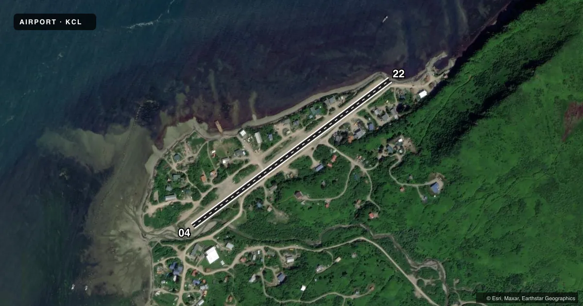
Runways & pattern
Full pagePattern entry · RWY 22
RIGHT TRAFFICRunway end performance
| End | TORA | TODA | ASDA | LDA | VGSI | Approach lights | Obstruction |
|---|---|---|---|---|---|---|---|
| 04 | — | — | — | — | — | — | 20', trees, 175' from thr, 140' R of cntrln, slope 8 |
| 22 | — | — | — | — | — | — | 150', hill, 1400' from thr, 175' R of cntrln, slope 9 |
Declared distances in feet. TORA = takeoff run available, TODA = takeoff distance, ASDA = accelerate-stop, LDA = landing distance.
Airport sketch
Runways drawn to scale from FAA survey coordinates, rendered over satellite imagery. Not for navigation.
Approaches & charts
Services on the field
Fuel grades, oxygen, maintenance, ramp storage and lighting — as declared to the FAA by the airport operator.
Fuel & services
- Fuel
- Not available
- Oxygen (bottled)
- Not available
- Oxygen (bulk)
- Not available
- Airframe repair
- Not available
- Power plant repair
- Not available
Ramp & ground
- Transient storage
- Not published
- Landing fee
- No fee published
- Customs
- Not available
- Wind indicator
- Yes
- Segmented circle
- No
Fuel & FBOs
Cheapest 100LL and Jet A on the field and nearby. Always confirm with the FBO before taxi.
Airport notes
Surface conditions, obstructions, local procedures, lighting outages and other notes published with each FAA cycle.
General notes
- SEABIRDS ON & INVOF ARPT.
- RY COND NOT MONITORED; RECOMMEND VISUAL INSPECTION PRIOR TO USING.
- VEHICLE & PEDESTRIANS FREQUENTLY USE NUMEROUS ROADS AND TRAILS THAT CROSS RY.
- SEVERAL OBSTACLES SURROUND RY.
- WX CAMERA AVBL ON INTERNET AT HTTPS://WEATHERCAMS.FAA.GOV
Runway surface & condition
- 04/22SEVERAL ROADS AND TRAILS CROSS RY 04/22.
Approach & departure obstructions
- 04RWY THLDS MKD WITH ORANGE REFLECTIVE CONES.
- 22SHEER CLIFF 1400 FT FM THLD 175 FT LEFT.
Other notes
- OWNER907-269-0760
- 04/22SFC CONTAINS NUMEROUS LARGE ROCKS AND PUDDLES.
- 04/22LOOSE ROCKS ON RY SFC UP TO 6 IN.
VFR map & nearby airports
VFR sectional. Tap any ICAO chip to open that airport.
Key facts · KCL
Answer card- ICAO
- KCL
- Name
- CHIGNIK LAGOON
- Location
- CHIGNIK LAGOON, ALASKA
- Elevation
- 27.7 ft MSL
- Traffic pattern altitude
- 1,027.7 ft MSL (1,000 AGL)
- Control tower
- Non-towered (use CTAF)
- Total runways
- 1
- Longest runway
- 04/22 · 2,200 ft
- Published ILS approaches
- 0
- Published frequencies
- 1
- Magnetic variation
- 19°
- Current flight rules
- VFR
- Current wind
- 220° at 11 kt
- Favored runway now
- RWY 22
Chignik Lagoon Airport sits in Chignik Lagoon, Alaska. Field elevation is 27.7 ft MSL. It has one runway, 04/22, which is 2,200 ft long and surfaced with gravel and dirt. There is no control tower. CTAF is 122.8. No ILS approaches are published.
Pattern altitude is not published. Use the standard 1,000 ft AGL for light piston operations unless the current Chart Supplement or local guidance says otherwise. That puts the pattern at about 1,028 ft MSL based on the listed field elevation. The runway environment deserves a close look before landing. Roads and trails cross the runway. Loose rocks up to 6 inches are reported on the surface. Large rocks and puddles are also noted. Runway condition is not monitored, so a visual inspection before use is a good idea.
There is a sheer cliff about 1,400 ft from the threshold, 175 ft left of centerline. Seabirds are also reported in the area. Thresholds on runway 04 are marked with orange reflective cones. No on-field FBOs are listed, so contact the airport operator directly before arrival if you need services. The airport contact phone number is 907-269-0760. Weather camera coverage is available online for a current look at conditions.