METAR & TAF A79
A79 does not publish a METAR.
Showing the nearest reporting station: PAJC (CHIGNIK) · 13.9 NM away. Conditions at A79 may differ.
METAR · PAJC
Observed 06:56Z
PAJC 280656Z AUTO 21011KT 10SM OVC037 12/05 A3013 RMK AO2 SLP205 T01220050
- Wind
- 210° @ 11 kt
- Visibility
- 10 SM
- Temp / Dew
- 12°C / 5°C
- Altimeter
- 30.13 inHg
- Clouds
- OVC
- Density alt
- -558 ft
- Ceiling
- 3,700 ft AGL
- Rules
- VFR
Airport info & contacts
Manager on record, flight service, ARTCC, attendance schedule and pattern altitude — published by the FAA and refreshed every 28 days.
Location
- From city
- 0 NM WSW
- VFR sectional
- COLD BAY
- ARTCC
- ZAN · ANCHORAGE
- NOTAM facility
- ENA (NOTAM-D)
Airport manager
- Name
- FLOYD WILSON
- Phone
- 907-246-3325
- Address
- PO BOX 65, KING SALMON AK 99613
Flight service · Hours
- FSS ENA
- KENAI907-283-72111-866-864-1737
- Attendance
- Unattended
Frequencies
Tap any row to copy the frequency to your clipboard.
Runways & pattern
Full pagePattern entry · RWY 26
LEFT TRAFFICRunway end performance
| End | TORA | TODA | ASDA | LDA | VGSI | Approach lights | Obstruction |
|---|---|---|---|---|---|---|---|
| 08 | — | — | — | — | — | — | 6', brush, 0' from thr, 95' R of cntrln, slope 0 |
| 26 | — | — | — | — | — | — | 7', brush, 0' from thr, 95' R of cntrln, slope 0 |
Declared distances in feet. TORA = takeoff run available, TODA = takeoff distance, ASDA = accelerate-stop, LDA = landing distance.
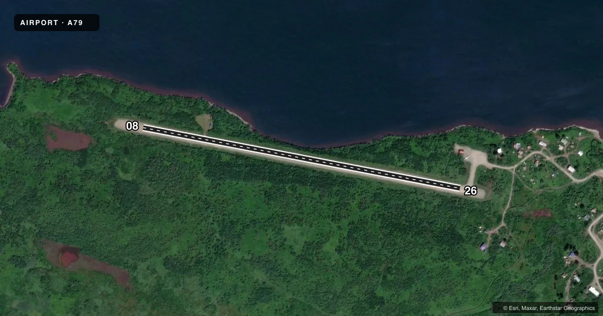
Airport sketch
Runways drawn to scale from FAA survey coordinates, rendered over satellite imagery. Not for navigation.
Approaches & charts
Services on the field
Fuel grades, oxygen, maintenance, ramp storage and lighting — as declared to the FAA by the airport operator.
Fuel & services
- Fuel
- Not available
- Oxygen (bottled)
- Not available
- Oxygen (bulk)
- Not available
- Airframe repair
- Not available
- Power plant repair
- Not available
Ramp & ground
- Transient storage
- Not published
- Landing fee
- No fee published
- Customs
- Not available
- Wind indicator
- Yes
- Segmented circle
- No
Fuel & FBOs
Cheapest 100LL and Jet A on the field and nearby. Always confirm with the FBO before taxi.
Airport notes
Surface conditions, obstructions, local procedures, lighting outages and other notes published with each FAA cycle.
General notes
- RY SAFETY AREAS ROUGH, RUTTED, AND UNEVEN.
- RY COND NOT MONITORED - RCMD VISUAL INSPN PRIOR TO USE.
- HILL S OF RY 08/26 150 FT HIGH; RUNS PARALLEL TO RY.
- WX CAMERA AVBL ON INTERNET AT HTTPS://WEATHERCAMS.FAA.GOV
- RY SLOPES DOWN TOWARD THE WEST.
Runway surface & condition
- 08/26BRUSH UP TO 15 FT ALONG ENTIRE RY LENGTH.
Other notes
- 08/26RUTTED AND UNEVEN SURFACE WITH NO CROWN ENTIRE LENGTH. LOOSE ROCKS UP TO 4" ON SURFACE.
VFR map & nearby airports
VFR sectional. Tap any ICAO chip to open that airport.
Key facts · A79
Answer card- ICAO
- A79
- Name
- CHIGNIK LAKE
- Location
- CHIGNIK LAKE, ALASKA
- Elevation
- 50 ft MSL
- Traffic pattern altitude
- 1,050 ft MSL (1,000 AGL)
- Control tower
- Non-towered (use CTAF)
- Total runways
- 1
- Longest runway
- 08/26 · 2,800 ft
- Published ILS approaches
- 0
- Published frequencies
- 1
- Magnetic variation
- 19°
- Current flight rules
- VFR
- Current wind
- 210° at 11 kt
- Favored runway now
- RWY 26
Chignik Lake Airport sits in Chignik Lake, Alaska. The field elevation is 50 ft MSL. It has one runway, 08/26, at 2,800 ft. There is no control tower. CTAF is 122.8. No ILS approaches are published.
Pattern altitude is not published. Use the standard 1,000 ft AGL pattern for light piston operations unless the current Chart Supplement or local traffic calls say otherwise. The runway headings are magnetic. Runway 08/26 is gravel. The published remarks call out a runway surface that is rutted and uneven with loose rocks up to 4 inches. The runway also slopes down toward the west. A hill south of the runway runs parallel to it. Brush up to 15 feet high is present along the full length. The runway safety areas are also rough and uneven.
No on-field FBOs are listed in the facts. Plan for self-sufficiency. Check the current Chart Supplement, the airport operator, or the FBO directly by phone before arrival if you need services. Runway condition is not monitored, so a visual inspection before use is a smart move here. A weather camera is available online for a current look at the surface and surroundings.