METAR & TAF PAVC
Current METAR
Observed 16:56Z
PAVC 281656Z AUTO 23017G28KT 6SM -RA BR OVC005 08/07 A3021 RMK AO2 PK WND 22029/1626 CIG 004V009 SLP231 P0001 T00780067 $
- Wind
- 230° @ 17G28 kt
- Visibility
- 6 SM
- Temp / Dew
- 8°C / 7°C
- Altimeter
- 30.21 inHg
- Clouds
- OVC
- Density alt
- -1,015 ft
- Ceiling
- 500 ft AGL
- Rules
- IFR
Airport info & contacts
Manager on record, flight service, ARTCC, attendance schedule and pattern altitude — published by the FAA and refreshed every 28 days.
Location
- From city
- 4 NM NE
- VFR sectional
- COLD BAY
- ARTCC
- ZAN · ANCHORAGE
- NOTAM facility
- KVC (NOTAM-D)
Airport manager
- Name
- HAROLD "HAP" KREMER
- Phone
- 907-532-5000
- Address
- BOX 97, COLD BAY AK 99571
Flight service · Hours
- FSS CDB
- COLD BAY907-532-24661-800-478-7250
- Attendance
- Unattended
Frequencies
Tap any row to copy the frequency to your clipboard.
Runways & pattern
Full pagePattern entry · RWY 26
LEFT TRAFFICRunway end performance
| End | TORA | TODA | ASDA | LDA | VGSI | Approach lights | Obstruction |
|---|---|---|---|---|---|---|---|
| 08 | — | — | — | — | PAPI 4-box left(4°) | — | 15', road, 611' from thr, 0' R of cntrln, slope 40 |
| 26 | — | — | — | — | PAPI 4-box left(3°) | — | 15', hill, 600' from thr, 336' R of cntrln, slope 40 |
Declared distances in feet. TORA = takeoff run available, TODA = takeoff distance, ASDA = accelerate-stop, LDA = landing distance.
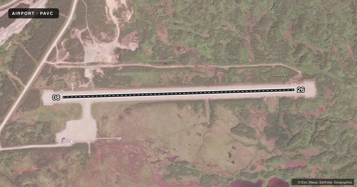
Airport sketch
Runways drawn to scale from FAA survey coordinates, rendered over satellite imagery. Not for navigation.
Approaches & charts
Services on the field
Fuel grades, oxygen, maintenance, ramp storage and lighting — as declared to the FAA by the airport operator.
Fuel & services
- Fuel
- Not available
- Oxygen (bottled)
- Not available
- Oxygen (bulk)
- Not available
- Airframe repair
- Not available
- Power plant repair
- Not available
Ramp & ground
- Transient storage
- Not published
- Landing fee
- No fee published
- Customs
- Not available
- Lighting schedule
- SEE RMK
- Beacon schedule
- SS-SR
- Beacon
- White / Green (civil land)(WG)
- Wind indicator
- Lighted
- Segmented circle
- Yes
Fuel & FBOs
Cheapest 100LL and Jet A on the field and nearby. Always confirm with the FBO before taxi.
Airport notes
Surface conditions, obstructions, local procedures, lighting outages and other notes published with each FAA cycle.
General notes
- 16+ KTS WINDS IN NE E NW QUADTS. WIND FUNNELS DOWN CANYON WEST OF RWY 08.
- RWY COND NOT MONITORED; RCMD VISUAL INSPECTION PRIOR TO USING.
- WX CAMERA AVBL ON INTERNET AT HTTPS://WEATHERCAMS.FAA.GOV.
- FBO SERVICE PHONE: 907-497-2683
- COLD TEMPERATURE AIRPORT. ALTITUDE CORRECTION REQUIRED AT OR BELOW -8C.
Lighting notes
- ACVT REIL RWY 08, 26; PAPI RWY 08, 26; MIRL RWY 08/26 - CTAF.
Approach & departure obstructions
- 08PAPI UNUSBL BYD 5 DEGS LEFT AND RIGHT CNTRLN.
Other notes
- 08/26RWY SOFT DURING SPRING BREAKUP & AFTER HVY RAIN.
- 08/26GRVL-DIRT
VFR map & nearby airports
VFR sectional. Tap any ICAO chip to open that airport.
Key facts · PAVC
Answer card- ICAO
- PAVC
- Name
- KING COVE
- Location
- KING COVE, ALASKA
- Elevation
- 148.9 ft MSL
- Traffic pattern altitude
- 1,148.9 ft MSL (1,000 AGL)
- Control tower
- Non-towered (use CTAF)
- Total runways
- 1
- Longest runway
- 08/26 · 3,500 ft
- Published ILS approaches
- 0
- Published frequencies
- 1
- Magnetic variation
- 10°
- Current flight rules
- IFR
- Current wind
- 230° at 17 kt
- Favored runway now
- RWY 26
King Cove Airport sits in King Cove, Alaska. Field elevation is 148.9 ft MSL. The airport has one runway. Runway 08/26 is 3,500 ft long with a gravel and dirt surface. There is no control tower. CTAF is 122.9. No ILS approaches are published here.
Pattern altitude is not published. Use 1,000 ft AGL for light piston traffic unless the current FAA Chart Supplement says otherwise. The field has activated runway end identifier lights on both ends. Medium intensity runway lights are also published for 08/26. PAPI is available on both runway ends. The runway condition is not monitored, so a visual inspection before landing is a good idea.
This is a cold temperature airport. Altitude correction is required at or below minus 8 degrees Celsius. Winds of 16 knots or more can show up in the northeast, east and northwest quadrants. Wind can also funnel down the canyon west of runway 08. Runway 08 can be soft during spring breakup and after heavy rain. The PAPI on runway 08 is unusable beyond 5 degrees left and right of centerline. No on-field FBOs are listed. The published remarks give an FBO service phone number of 907-497-2683 for current help before arrival.