METAR & TAF PAKF
Current METAR
Observed 19:56Z
PAKF 281956Z AUTO 20011G20KT 10SM FEW021 OVC038 11/06 A3018 RMK AO2 SLP220 T01060061 PNO $
- Wind
- 200° @ 11G20 kt
- Visibility
- 10 SM
- Temp / Dew
- 11°C / 6°C
- Altimeter
- 30.18 inHg
- Clouds
- OVC
- Density alt
- -780 ft
- Ceiling
- 3,800 ft AGL
- Rules
- VFR
Airport info & contacts
Manager on record, flight service, ARTCC, attendance schedule and pattern altitude — published by the FAA and refreshed every 28 days.
Location
- From city
- 0 NM ESE
- VFR sectional
- COLD BAY
- ARTCC
- ZAN · ANCHORAGE
- NOTAM facility
- KFP (NOTAM-D)
Airport manager
- Name
- JEFF DOERNING
- Phone
- 907-532-5000
- Address
- BOX 97, COLD BAY AK 99571
Flight service · Hours
- FSS CDB
- COLD BAY907-532-24661-800-478-7250
- Attendance
- Unattended
Frequencies
Tap any row to copy the frequency to your clipboard.
Runways & pattern
Full pagePattern entry · RWY 14
LEFT TRAFFICRunway end performance
| End | TORA | TODA | ASDA | LDA | VGSI | Approach lights | Obstruction |
|---|---|---|---|---|---|---|---|
| 14 | — | — | — | — | — | — | 750', hill, 5000' from thr, 625' R of cntrln, slope 6 |
| 32 | — | — | — | — | — | — | 270', hill, 3200' from thr, 400' R of cntrln, slope 11 |
Declared distances in feet. TORA = takeoff run available, TODA = takeoff distance, ASDA = accelerate-stop, LDA = landing distance.
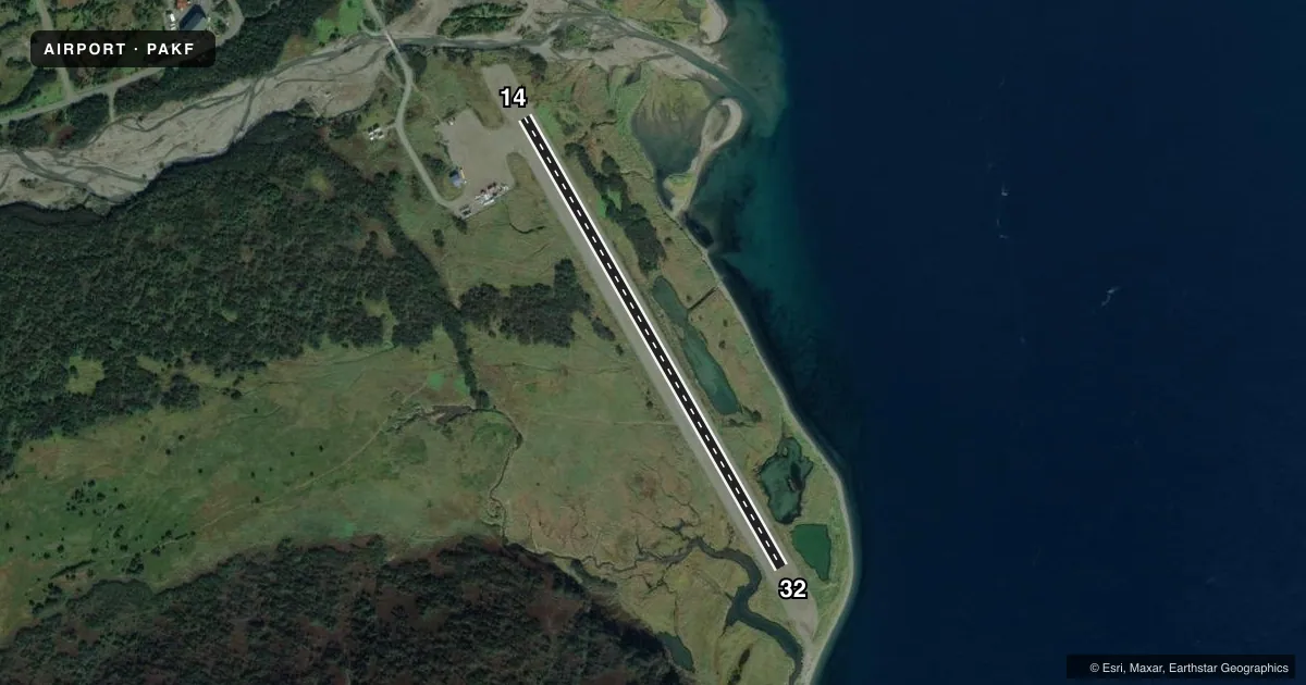
Airport sketch
Runways drawn to scale from FAA survey coordinates, rendered over satellite imagery. Not for navigation.
Approaches & charts
Services on the field
Fuel grades, oxygen, maintenance, ramp storage and lighting — as declared to the FAA by the airport operator.
Fuel & services
- Fuel
- Not available
Ramp & ground
- Transient storage
- Not published
- Landing fee
- No fee published
- Customs
- Not available
- Wind indicator
- Yes
- Segmented circle
- Yes
Fuel & FBOs
Cheapest 100LL and Jet A on the field and nearby. Always confirm with the FBO before taxi.
Airport notes
Surface conditions, obstructions, local procedures, lighting outages and other notes published with each FAA cycle.
General notes
- FQT TURB & HIGH WINDS INVOF ARPT. BEARS & LRG BIRDS ALG BEACH ADJ TO RWY.
- PSBL SOFT & UNUSBL RWY SFC DURG SPRING & HVY RAIN. RWY COND UNMNT; RCMND VISUAL INSP BFR USE.
- WX CAMERA AVBL ON INTERNET AT HTTPS://WEATHERCAMS.FAA.GOV.
- CTN: VEHICLES USE RWY TO ACCESS BEACH.
Runway surface & condition
- 14/32MTUS TRRN NEAR RWY.
- 14/32NO EDGE MKRS.
VFR map & nearby airports
VFR sectional. Tap any ICAO chip to open that airport.
Key facts · PAKF
Answer card- ICAO
- PAKF
- Name
- FALSE PASS
- Location
- FALSE PASS, ALASKA
- Elevation
- 18.3 ft MSL
- Traffic pattern altitude
- 1,018.3 ft MSL (1,000 AGL)
- Control tower
- Non-towered (use CTAF)
- Total runways
- 1
- Longest runway
- 14/32 · 2,150 ft
- Published ILS approaches
- 0
- Published frequencies
- 1
- Magnetic variation
- 16°
- Current flight rules
- VFR
- Current wind
- 200° at 11 kt
- Favored runway now
- RWY 14
False Pass Airport sits in False Pass, Alaska. Field elevation is 18.3 ft MSL. The airport has one runway. Runway 14/32 is 2,150 ft long with a gravel-dirt surface. It is an uncontrolled field with CTAF 122.9. No ILS approaches are published. Pattern altitude is not published, so use standard 1,000 ft AGL for light piston traffic unless the current Chart Supplement says otherwise.
There are no on-field FBOs listed here. Plan fuel and services with the airport operator or the FBO directly by phone before you go. The published remarks matter here. The runway can get soft or unusable in spring and after heavy rain. A visual check before use is recommended because runway condition is not monitored. There are no edge markers on runway 14/32. Mountainous terrain is near the runway. Expect frequent turbulence and high winds in the area. Bears and large birds are reported along the beach next to the runway. Vehicles also use the runway to reach the beach, so keep your scan active on approach and after landing.