METAR & TAF PAHN
Current METAR
Observed 22:14Z
PAHN 272214Z AUTO 08007KT 050V110 9SM -RA BKN009 OVC017 13/11 A2994 RMK AO2 P0001 T01280111 TSNO
- Wind
- 080° @ 7 kt
- Visibility
- 9 SM
- Temp / Dew
- 13°C / 11°C
- Altimeter
- 29.94 inHg
- Clouds
- OVC
- Density alt
- -229 ft
- Ceiling
- 900 ft AGL
- Rules
- IFR
Airport info & contacts
Manager on record, flight service, ARTCC, attendance schedule and pattern altitude — published by the FAA and refreshed every 28 days.
Location
- From city
- 3 NM W
- VFR sectional
- JUNEAU
- ARTCC
- ZAN · ANCHORAGE
- NOTAM facility
- HNS (NOTAM-D)
Airport manager
- Name
- MATT BORON
- Phone
- 907-766-2340
- Address
- BOX 302, HAINES AK 99827
Flight service · Hours
- FSS JNU
- JUNEAU907-586-73801-866-297-2236
- Attendance
- Unattended
Frequencies
Tap any row to copy the frequency to your clipboard.
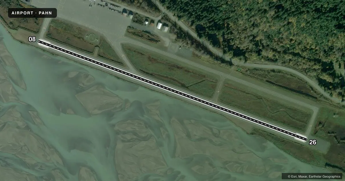
Runways & pattern
Full pagePattern entry · RWY 08
RIGHT TRAFFICRunway end performance
| End | TORA | TODA | ASDA | LDA | VGSI | Approach lights | Obstruction |
|---|---|---|---|---|---|---|---|
| 08 | — | — | — | — | PAPI 4-box left(4°) | — | 10', brush, 200' from thr, 0' R of cntrln, slope 0 |
| 26 | — | — | — | — | PAPI 4-box left(4°) | — | 5', brush, 200' from thr, 0' R of cntrln, slope 0 |
Declared distances in feet. TORA = takeoff run available, TODA = takeoff distance, ASDA = accelerate-stop, LDA = landing distance.
Airport sketch
Runways drawn to scale from FAA survey coordinates, rendered over satellite imagery. Not for navigation.
Approaches & charts
Services on the field
Fuel grades, oxygen, maintenance, ramp storage and lighting — as declared to the FAA by the airport operator.
Fuel & services
- Fuel
- 100LLA
Ramp & ground
- Transient storage
- Tie-down
- Landing fee
- No fee published
- Customs
- Not available
- Lighting schedule
- SEE RMK
- Beacon schedule
- SS-SR
- Beacon
- White / Green (civil land)(WG)
- Wind indicator
- Lighted
- Segmented circle
- Yes
Fuel & FBOs
Cheapest 100LL and Jet A on the field and nearby. Always confirm with the FBO before taxi.
Airport notes
Surface conditions, obstructions, local procedures, lighting outages and other notes published with each FAA cycle.
General notes
- NARROW APCH FM NW, MTNS BOTH SIDES; TURBC ON NW APCH, BLUFF NW.
- BIRDS, BEARS & MOOSE ON & INVOF ARPT.
- SAFETY AREA 4600 FT X 150 FT; 300 FT GRAVEL SAFETY AREA EACH END.
- ARPT COND NOT MNT; ARPT MAINT ON IREG BASIS; VISUAL INSP RCMDD.
- PAJA ONTO RWY.
- CLSD TO ACR OPS WITH MORE THAN 30 PAX SEATS.
- RCMD DALGT OPS ONLY.
- ALERT: SEE GENOTS - ENROUTE CTAF FREQS.
- WX CAMERA AVBL ON INTERNET AT HTTPS://WEATHERCAMS.FAA.GOV
- ARPT CLSD TO ACFT OVER 12500 LBS OR MORE EXC PPR - ARPT SAFETY & SCTY; DOT & PUB FAC; P.O. BOX 112506; JUNEAU AK 99811-2506 - 907-465-1786.
- TWY D NOT MNTND 15 OCT-30 APR.
- FUEL SVC AVBL - 907-766-3190.
- TWY & PRKG APRON NA.
- COLD TEMPERATURE AIRPORT. ALTITUDE CORRECTION REQUIRED AT OR BELOW -18C.
Lighting notes
- ACTVT REIL RWY 08 & 26; PAPI RWY 08 & 26; MIRL RWY 08/26 - CTAF.
Runway surface & condition
- 08/26PCR VALUE: 40/F/B/X/U
Approach & departure obstructions
- 2650 FT TREES 1000 FT SE.
- 08PAPI UNUSBL BYD 5 DEGS LEFT OF CNTRLN.
Other notes
- 08/26SAND TO ENHANCE RWY FRICTION MAY NOT MEET FAA SPEC.
VFR map & nearby airports
VFR sectional. Tap any ICAO chip to open that airport.
Key facts · PAHN
Answer card- ICAO
- PAHN
- Name
- HAINES
- Location
- HAINES, ALASKA
- Elevation
- 29.1 ft MSL
- Traffic pattern altitude
- 1,029.1 ft MSL (1,000 AGL)
- Control tower
- Non-towered (use CTAF)
- Total runways
- 1
- Longest runway
- 08/26 · 4,000 ft
- Published ILS approaches
- 0
- Published frequencies
- 1
- Magnetic variation
- 20°
- Current flight rules
- IFR
- Current wind
- 080° at 7 kt
- Favored runway now
- RWY 08
Haines Airport is in Haines, Alaska. The field elevation is 29.1 ft MSL. It has one runway, 08/26, which is 4,000 ft long. There is no control tower. CTAF is 122.9. No ILS approaches are published here.
Pattern altitude is not published. Use 1,000 ft AGL for light piston traffic unless the current Chart Supplement says otherwise. Delta Western is on the field. It carries AVGAS 100LL and Jet A. Call (907) 766-3190 for current service details before you go.
This is a mountain airport with a narrow approach from the northwest. The published remarks call out mountains on both sides. They also note turbulence near the bluff on the northwest approach. The field is also listed as not regularly maintained. Visual inspection is a good idea before you commit. The airport is recommended for daylight operations only. Runway lighting is CTAF-controlled. PAPI and runway end identifier lights are published on both ends. The PAPI on runway 08 is unusable more than 5 degrees left of centerline. Cold weather is a factor here too. Altitude correction is required at or below minus 18 degrees C. Birds, bears and moose are reported on and near the airport.