METAR & TAF PAGY
Current METAR
Observed 04:53Z
PAGY 270453Z AUTO 00000KT BKN090 14/12 A2973 RMK AO2 SLP067 T01390117 TSNO
- Wind
- 000° @ 0 kt
- Visibility
- —
- Temp / Dew
- 14°C / 12°C
- Altimeter
- 29.73 inHg
- Clouds
- BKN
- Density alt
- 170 ft
- Ceiling
- 9,000 ft AGL
- Rules
- VFR
Airport info & contacts
Manager on record, flight service, ARTCC, attendance schedule and pattern altitude — published by the FAA and refreshed every 28 days.
Location
- From city
- 0 NM NW
- VFR sectional
- JUNEAU
- ARTCC
- ZAN · ANCHORAGE
- NOTAM facility
- SGY (NOTAM-D)
Airport manager
- Name
- SHAUN MCKNIGHT
- Phone
- 907-983-2323
- Address
- BOX 356, SKAGWAY AK 99840
Flight service · Hours
- FSS JNU
- JUNEAU907-586-73801-866-297-2236
- Attendance
- Unattended
Frequencies
Tap any row to copy the frequency to your clipboard.
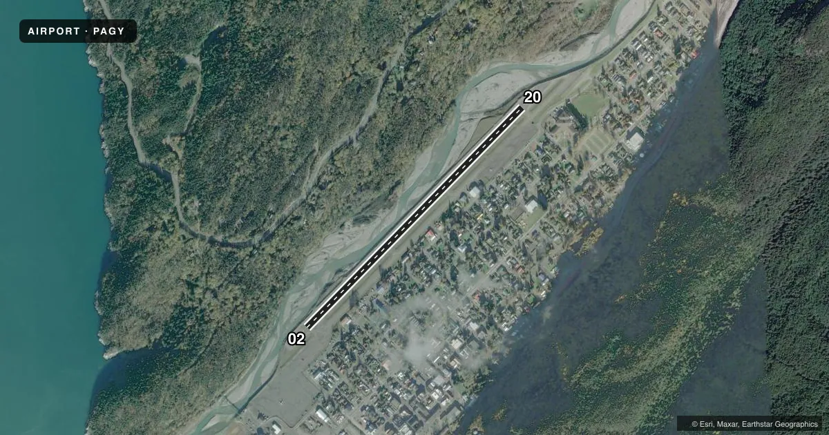
Runways & pattern
Full pagePattern entry · RWY 02
LEFT TRAFFICRunway end performance
| End | TORA | TODA | ASDA | LDA | VGSI | Approach lights | Obstruction |
|---|---|---|---|---|---|---|---|
| 02 | — | — | — | — | — | — | 96', trees, 620' from thr, 220' R of cntrln, slope 4 |
| 20 | — | — | — | — | — | — | 80', trees, 551' from thr, 200' R of cntrln, slope 4 |
Declared distances in feet. TORA = takeoff run available, TODA = takeoff distance, ASDA = accelerate-stop, LDA = landing distance.
Airport sketch
Runways drawn to scale from FAA survey coordinates, rendered over satellite imagery. Not for navigation.
Approaches & charts
Services on the field
Fuel grades, oxygen, maintenance, ramp storage and lighting — as declared to the FAA by the airport operator.
Fuel & services
- Fuel
- 100LL
- Other services
- CHTR
Ramp & ground
- Transient storage
- Tie-down
- Landing fee
- No fee published
- Customs
- Not available
- Lighting schedule
- SEE RMK
- Wind indicator
- Lighted
- Segmented circle
- No
Fuel & FBOs
Cheapest 100LL and Jet A on the field and nearby. Always confirm with the FBO before taxi.
Airport notes
Surface conditions, obstructions, local procedures, lighting outages and other notes published with each FAA cycle.
General notes
- ARPT COND UNMNT; MAINT IREG; RCMND VISUAL INSP PRIOR TO USE.
- BIRDS & BEARS INVOF ARPT.
- JUNEAU FSS FONE IN FUEL AREA.
- LIGHT ACFT & HEL TFC JUNE 1 - SEP 15 - INFO AMGR.
- ACFT OVR 12500 LB GWT NA EXC PPR IN WRITING - AMGR.
- PAJA TO RWY, TWY & PRKG APRON NA.
- RCMD DALGT OPS ONLY.
- ACR OPS OVER 30 PAX SEATS NA.
- WX CAMERA AVBL ON INTERNET AT HTTPS://WEATHERCAMS.FAA.GOV
Lighting notes
- ACTVT REIL RWY 02 & 20; MIRL RWY 02/20 - CTAF.
Fuel notes
- 100LLFUEL MON-FRI 0800-1700 - 907-983-2259; AFT HR - 907-612-0049.
Approach & departure obstructions
- 02ALERT: SEE GENOT FOR RWY 02 DEP INFO & ENR CTAF FREQS. DEP REQ HIGH PER CLIMB DUE TO TRRN. DEP MAY DOGLEG EAST BFR TURN CROSSWIND TO INCR ALT; MNTN RWY HDG AT LEAST 1/2 MI BFR DOGLEG TO AVOID SCHOOL & PLAYGROUND.
- 20APCH IN NRW CANYON; TURB & HIGH OBSTNS. SCHOOL & PLAYGROUND INVOF APCH END.
- 02NSTD OMNIDIRECTIONAL.
- 20NSTD OMNIDIRECTIONAL.
VFR map & nearby airports
VFR sectional. Tap any ICAO chip to open that airport.
Key facts · PAGY
Answer card- ICAO
- PAGY
- Name
- SKAGWAY
- Location
- SKAGWAY, ALASKA
- Elevation
- 44 ft MSL
- Traffic pattern altitude
- 1,044 ft MSL (1,000 AGL)
- Control tower
- Non-towered (use CTAF)
- Total runways
- 1
- Longest runway
- 02/20 · 3,550 ft
- Published ILS approaches
- 0
- Published frequencies
- 1
- Magnetic variation
- 29°
- Current flight rules
- VFR
- Current wind
- 000° at 0 kt
- Favored runway now
- –
Skagway Airport sits in Skagway, Alaska at 44 ft MSL. It has one runway, 02/20, which is 3,550 ft long and paved. There is no control tower. CTAF is 122.9. No ILS approaches are published here.
The pattern altitude is not published. Use the standard 1,000 ft AGL pattern unless local guidance says otherwise. For a field this close to terrain, that is only a starting point. The published remarks call for daylight operations only. They also warn that departure from runway 02 needs a strong climb because of terrain. A dogleg east may be used after takeoff to build altitude. Stay on runway heading for at least one-half mile before turning so you do not drift toward the school and playground. Approach to runway 20 is in a narrow canyon with turbulence and high obstacles. The school and playground are also near that end.
No on-field FBOs are listed. Fuel availability is published for 100LL only. Weekday service and after-hours contact numbers are in the Chart Supplement. Light aircraft and helicopter traffic is common from June 1 through September 15. The airport also has a few operating limits. Aircraft over 30 passenger seats are not authorized. Aircraft over 12,500 pounds gross weight are not authorized without prior written permission from the airport manager.