METAR & TAF KXWA
Current METAR
Observed 17:51Z
KXWA 271751Z AUTO 05009KT 10SM CLR 29/14 A2994 RMK AO2 SLP126 T02940144 10300 20172 58001
- Wind
- 050° @ 9 kt
- Visibility
- 10 SM
- Temp / Dew
- 29°C / 14°C
- Altimeter
- 29.94 inHg
- Clouds
- CLR
- Density alt
- 4,577 ft
- Ceiling
- Unlimited
- Rules
- VFR
Airport info & contacts
Manager on record, flight service, ARTCC, attendance schedule and pattern altitude — published by the FAA and refreshed every 28 days.
Location
- From city
- 9 NM NW
- VFR sectional
- BILLINGS
- ARTCC
- ZLC · SALT LAKE CITY
- NOTAM facility
- XWA (NOTAM-D)
Airport manager
- Name
- RYAN O'REAR
- Phone
- 701-875-8594
- Address
- 14127 JENSEN LANE, SUITE 200, WILLISTON ND 58801
Flight service · Hours
- FSS GFK
- GRAND FORKS1-800-WX-BRIEF
- Attendance
- 0700-1900
Frequencies
Tap any row to copy the frequency to your clipboard.
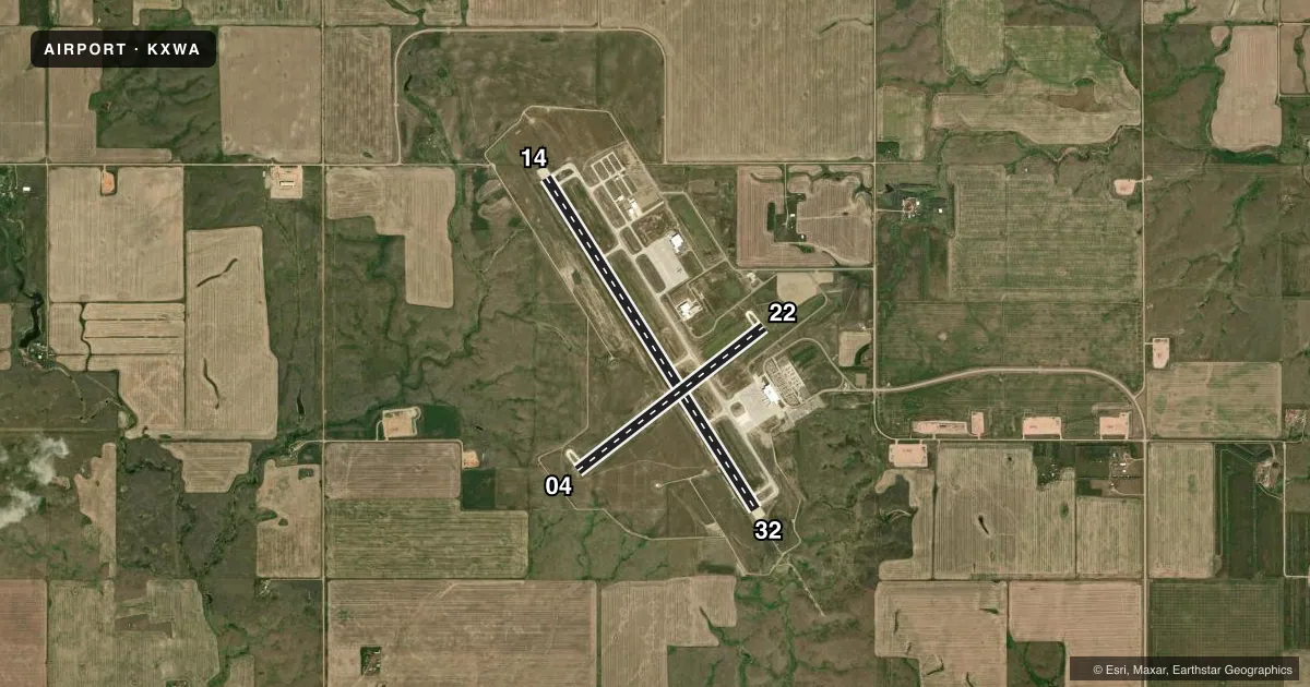
Runways & pattern
Full pagePattern entry · RWY 04
LEFT TRAFFIC| Runway | Heading (°M) | Length | Surface | Traffic |
|---|---|---|---|---|
| 14/32 | 140° / 320° | 7,503 ft | CONC | Standard L |
| 04/22Favored | 44° / 224° | 4,502 ft | CONC | Standard L |
Runway end performance
| End | TORA | TODA | ASDA | LDA | VGSI | Approach lights | Obstruction |
|---|---|---|---|---|---|---|---|
| 14 | 7,503' | 7,503' | 7,503' | 7,503' | PAPI 4-box left(3°) | — | — |
| 32 | 7,503' | 7,503' | 7,503' | 7,503' | PAPI 4-box left(3°) | MALSR | — |
| 04 | 4,502' | 4,502' | 4,502' | 4,502' | PAPI 2-box left(3°) | — | — |
| 22 | 4,502' | 4,502' | 4,502' | 4,502' | PAPI 2-box left(3°) | — | — |
Declared distances in feet. TORA = takeoff run available, TODA = takeoff distance, ASDA = accelerate-stop, LDA = landing distance.
Airport sketch
Runways drawn to scale from FAA survey coordinates, rendered over satellite imagery. Not for navigation.
Approaches & charts
ILS · 1
Services on the field
Fuel grades, oxygen, maintenance, ramp storage and lighting — as declared to the FAA by the airport operator.
Fuel & services
- Fuel
- 100LLA
- Oxygen (bottled)
- Not available
- Oxygen (bulk)
- High pressure
- Airframe repair
- Major
- Power plant repair
- Major
- Other services
- AFRT,AGRI,AMB,CARGO,CHTR,INSTR,RNTL,SURV
Ramp & ground
- Transient storage
- Tie-down
- Hangar
- Customs
- Available
- Lighting schedule
- SEE RMK
- Beacon schedule
- SS-SR
- Beacon
- White / Green (civil land)(WG)
- Wind indicator
- Lighted
- Segmented circle
- Yes
Fuel & FBOs
Cheapest 100LL and Jet A on the field and nearby. Always confirm with the FBO before taxi.
Airport notes
Surface conditions, obstructions, local procedures, lighting outages and other notes published with each FAA cycle.
General notes
- BIRDS & DEER ON & INVOF ARPT.
- ARPT SFC CONDS UNMON 0100-0500 DAILY.
- FOR US CUSTOMS CALL 701-875-2128.
Lighting notes
- ACTVT MALSR RWY 32; REIL RWY 04, 14, & 22; MIRL RWY 04/22; HIRL RWY 14/32 - CTAF. HIRL RWY 14/32 OPRNL ON LOW INTST, TO INCR INTST - CTAF. PAPI RWYS 4, 14, 22 & 32 OPR CONSLY.
Fuel notes
- 100LLFOR AFT HRS FUEL, CTC 701-570-5345
Runway surface & condition
- 04/22PCR VALUE: 148/R/D/W/T
- 14/32PCR VALUE: 622/R/D/W/T
- 04/22RWY 04/22 NOT AVBL FOR PART 121/PART 380 OPS WITH SKED PAX CARRYING OPS MORE THAN 9 PAX SEATS AND NON-SKED PAX CARRYING OPS MORE THAN 30 PAX SEATS.
Other notes
- FOR US CUSTOMS, CALL 701-770-2460/2461.
- SUPPL WND INDCRS RWYS 14/32 & 04/22.
VFR map & nearby airports
VFR sectional. Tap any ICAO chip to open that airport.
Key facts · KXWA
Answer card- ICAO
- KXWA
- Name
- WILLISTON BASIN INTL
- Location
- WILLISTON, NORTH DAKOTA
- Elevation
- 2,356 ft MSL
- Traffic pattern altitude
- 3,356 ft MSL (1,000 AGL)
- Control tower
- Non-towered (use CTAF)
- Total runways
- 2
- Longest runway
- 14/32 · 7,503 ft
- Published ILS approaches
- 1
- Published frequencies
- 2
- Magnetic variation
- 8°
- Current flight rules
- VFR
- Current wind
- 050° at 9 kt
- Favored runway now
- RWY 04
Williston Basin Intl sits in Williston, North Dakota at 2,356 ft MSL. It has two concrete runways. The longest is 14/32 at 7,503 ft. The field is non-towered. CTAF and UNICOM are both 122.8. The published ILS serves runway 32. Pattern altitude is not published, so use 1,000 ft AGL for light piston operations unless the current FAA Chart Supplement says otherwise.
Overland Aviation is on the field. It carries 100LL, Jet A and Jet A Prist. Call (701) 875-4334 for current service details. After-hours fuel contact is listed in the remarks at 701-570-5345. Runway 32 has MALSR lighting. Runway 04, 14 and 22 have REIL. Runway 14/32 has HIRL on CTAF. The HIRL can be increased from low intensity on CTAF. PAPI is published for all runway ends.
This is a higher-elevation field with real weather and density altitude considerations. Birds and deer are noted on and near the airport. Surface conditions are unmonitored from 0100 to 0500 daily. Runway 04/22 is also not available for certain large passenger-carrying Part 121 and Part 380 operations. Check the current FAA Chart Supplement before you go if you need customs, night ops detail, or any operational restriction beyond the published remarks.