METAR & TAF KXNA
Current METAR
Observed 19:53Z
KXNA 271953Z 22010G18KT 10SM CLR 36/20 A2991 RMK AO2 SLP109 T03610200
- Wind
- 220° @ 10G18 kt
- Visibility
- 10 SM
- Temp / Dew
- 36°C / 20°C
- Altimeter
- 29.91 inHg
- Clouds
- CLR
- Density alt
- 4,130 ft
- Ceiling
- Unlimited
- Rules
- VFR
Airport info & contacts
Manager on record, flight service, ARTCC, attendance schedule and pattern altitude — published by the FAA and refreshed every 28 days.
Location
- From city
- 15 NM NW
- VFR sectional
- KANSAS CITY
- ARTCC
- ZME · MEMPHIS
- NOTAM facility
- XNA (NOTAM-D)
Airport manager
- Name
- ANDREW BRANCH
- Phone
- 479-205-1000
- Address
- 1 AIRPORT BLVD, SUITE 100, BENTONVILLE AR 72713
Flight service · Hours
- FSS JBR
- JONESBORO1-800-WX-BRIEF
- Attendance
- ALL
Frequencies
Tap any row to copy the frequency to your clipboard.
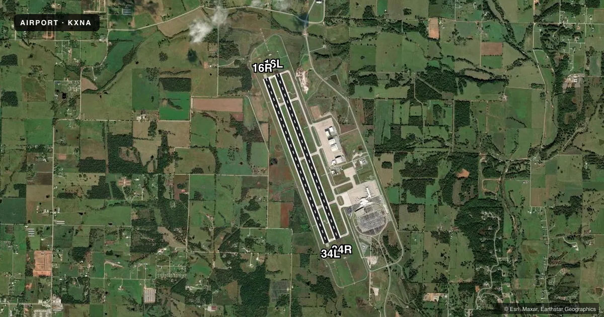
Runways & pattern
Full pagePattern entry · RWY 16L
LEFT TRAFFIC| Runway | Heading (°M) | Length | Surface | Traffic |
|---|---|---|---|---|
| 16L/34RFavored | 159° / 339° | 8,801 ft | CONC | Standard L |
| 16R/34L | 159° / 339° | 8,800 ft | CONC | Standard L |
Runway end performance
| End | TORA | TODA | ASDA | LDA | VGSI | Approach lights | Obstruction |
|---|---|---|---|---|---|---|---|
| 16L | 8,800' | 8,800' | 8,800' | 8,800' | PAPI 4-box left(3°) | MALSR | — |
| 34R | 8,800' | 8,800' | 8,800' | 8,800' | PAPI 4-box left(3°) | MALSR | — |
| 16R | 8,800' | 8,800' | 8,800' | 8,800' | — | — | — |
| 34L | 8,800' | 8,800' | 8,800' | 8,800' | — | — | — |
Declared distances in feet. TORA = takeoff run available, TODA = takeoff distance, ASDA = accelerate-stop, LDA = landing distance.
Airport sketch
Runways drawn to scale from FAA survey coordinates, rendered over satellite imagery. Not for navigation.
Approaches & charts
ILS · 2
Services on the field
Fuel grades, oxygen, maintenance, ramp storage and lighting — as declared to the FAA by the airport operator.
Fuel & services
- Fuel
- 100LLA
- Oxygen (bulk)
- Low pressure
- Other services
- AFRT,CHTR
Ramp & ground
- Transient storage
- Tie-down
- Hangar
- Lighting schedule
- SEE RMK
- Beacon schedule
- SS-SR
- Beacon
- White / Green (civil land)(WG)
- Wind indicator
- Lighted
- Segmented circle
- Yes
Fuel & FBOs
Cheapest 100LL and Jet A on the field and nearby. Always confirm with the FBO before taxi.
Airport notes
Surface conditions, obstructions, local procedures, lighting outages and other notes published with each FAA cycle.
General notes
- BIRD ACTIVITY ON & INVOF ARPT.
- CTN ELEVATED RWY THLD LGTS AER RWYS 16L & 34R.
- FOR CD CTC MEMPHIS ARTCC AT 901-368-8453/8449.
Lighting notes
- WHEN ATCT CLSD ACTVT MALSR RWY 16L&34R; HIRL RWY 16L/34R - CTAF. PAPI RWY 16L & 34R OPER CONSLY.
Fuel notes
- 100LLFOR FUEL SERVICES USE FREQ 130.05.
Runway surface & condition
- 16L/34RPCR VALUE: 765/R/C/W/T
- 16R/34LPCR VALUE: 765/R/C/W/T
Other notes
- SEE AIRSPACE LTR DATED 2/26/97.
- DSTC & DIRECTION TO ARPT FM SPRINGDALE IS 10 NM NW & FM ROGERS MSA IS 9 NM SW.
VFR map & nearby airports
VFR sectional. Tap any ICAO chip to open that airport.
Key facts · KXNA
Answer card- ICAO
- KXNA
- Name
- NORTHWEST ARKANSAS NTL
- Location
- FAYETTEVILLE/SPRINGDALE/ROGERS, ARKANSAS
- Elevation
- 1,288.2 ft MSL
- Traffic pattern altitude
- 2,288.2 ft MSL (1,000 AGL)
- Control tower
- Towered · 0530-2300
- Total runways
- 2
- Longest runway
- 16L/34R · 8,801 ft
- Published ILS approaches
- 2
- Published frequencies
- 12
- Magnetic variation
- 1°
- Current flight rules
- VFR
- Current wind
- 220° at 10 kt
- Favored runway now
- RWY 16L
Northwest Arkansas Ntl sits in Fayetteville, Springdale and Rogers, Arkansas. Field elevation is 1,288.2 ft MSL. The airport has two concrete runways. The longest is 8,801 ft. It is a towered field with the tower open from 0530 to 2300. KXNA has ILS approaches to runway ends 16L and 34R. Pattern altitude is not published in the facts. Verify the current Chart Supplement before you fly. For light piston traffic, use the standard 1,000 ft AGL pattern only if it matches current published guidance.
Regional Jet Center is on the field. It carries 100LL and Jet A Prist. Call (479) 205-1100 for current service details. The published remarks also note bird activity in and near the airport. When the tower is closed, the lighting setup for 16L and 34R is still usable from the CTAF. Precision approach path indicators for 16L and 34R operate continuously. For fuel service, use frequency 130.05.
This is Class C airspace. Expect busy airline and business traffic. The field elevation is high enough that summer density altitude can matter for takeoff performance. Watch the elevated threshold lights on 16L and 34R. If you need clearance delivery, contact Memphis ARTCC before departure. Check the current Chart Supplement for any airspace notes tied to the airspace letter referenced in the remarks.