METAR & TAF KSQL
Current METAR
Observed 16:47Z
KSQL 271647Z 26014KT 10SM SCT014 18/13 A3006
- Wind
- 260° @ 14 kt
- Visibility
- 10 SM
- Temp / Dew
- 18°C / 13°C
- Altimeter
- 30.06 inHg
- Clouds
- SCT
- Density alt
- 193 ft
- Ceiling
- Unlimited
- Rules
- VFR
Airport info & contacts
Manager on record, flight service, ARTCC, attendance schedule and pattern altitude — published by the FAA and refreshed every 28 days.
Location
- From city
- 2 NM NE
- VFR sectional
- SAN FRANCISCO
- Pattern altitude
- 800 ft AGL · 806 ft MSL
- ARTCC
- ZOA · OAKLAND
- NOTAM facility
- SQL (NOTAM-D)
Airport manager
- Name
- MICHAEL BYRNE
- Phone
- 650-573-3700
- Address
- 620 AIRPORT DR, SAN CARLOS CA 94070
Flight service · Hours
- FSS OAK
- OAKLAND1-800-WX-BRIEF
- Attendance
- 0800-1800
Frequencies
Tap any row to copy the frequency to your clipboard.
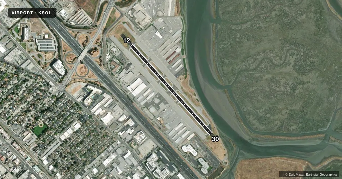
Runways & pattern
Full pagePattern entry · RWY 30
RIGHT TRAFFICRunway end performance
| End | TORA | TODA | ASDA | LDA | VGSI | Approach lights | Obstruction |
|---|---|---|---|---|---|---|---|
| 12 | — | — | — | — | VASI 2-box left(3°) | — | 18', pole, 565' from thr, 80' R of cntrln, slope 20 |
| 30 | — | — | — | — | VASI 2-box left(3°) | — | — |
Declared distances in feet. TORA = takeoff run available, TODA = takeoff distance, ASDA = accelerate-stop, LDA = landing distance.
Airport sketch
Runways drawn to scale from FAA survey coordinates, rendered over satellite imagery. Not for navigation.
Approaches & charts
Services on the field
Fuel grades, oxygen, maintenance, ramp storage and lighting — as declared to the FAA by the airport operator.
Fuel & services
- Fuel
- 100LLAA+UL94
- Oxygen (bottled)
- Not available
- Oxygen (bulk)
- Low pressure
- Airframe repair
- Minor
- Power plant repair
- Minor
- Other services
- CHTR,INSTR,RNTL,SALES
Ramp & ground
- Transient storage
- Tie-down
- Landing fee
- No fee published
- Customs
- Not available
- Lighting schedule
- SEE RMK
- Beacon schedule
- SS-SR
- Beacon
- White / Green (civil land)(WG)
- Wind indicator
- Lighted
- Segmented circle
- Yes
Fuel & FBOs
Cheapest 100LL and Jet A on the field and nearby. Always confirm with the FBO before taxi.
Airport notes
Surface conditions, obstructions, local procedures, lighting outages and other notes published with each FAA cycle.
General notes
- NO TGL OR STOP AND GO LDGS WHEN ATCT CLSD.
- CALM WIND RWY 12.
- NOISE SENSITIVE AREAS S THRU NE OF ARPT. FOR NOISE ABATEMENT PROCEDURES CTC AMGR (650) 573-3700.
- MIGRATORY BIRD ACT ON & INVOF OF ARPT.
- 100 FT STEEL TRANSMISSION TWRS AND POWERLINES LCTD 750 FT WEST AND PARALLEL TO RWY 12/30.
- 7 FT LIGHTED DIKE LCTD IN RWY SAFETY AREA ON APCH END RWY 30.
- FOR CD WHEN ATCT IS CLSD CTC NORCAL APCH AT 916-361-3829.
- RABBIT AVIATION 130.00
- LRG HEL SHOULD AVOID OVERFLIGHT OF DIRT INFIELD AREAS.
Lighting notes
- WHEN ATCT CLSD; ACTVT MIRL RWY 12/30 & REIL RWY 12/30 - 119.0
Approach & departure obstructions
- 307' LGTD DIKE 100' E OF CNTRLN AT THR, EXTENDING TO 60' E OF CNTRLN AT END OF PRIMARY SFC.
- 12HEL RIGHT TFC RWY 12/LEFT TFC RWY 30.
- 30FIXED-WING RIGHT TFC RWY 30/LEFT TFC RWY 12.
- 30UNUSBL BYD 8 DEG LEFT OF CNTRLN.
- 30LEVEE
Other notes
- APPLIES TO BOTH-FIXED WING AND HEL.
- OWNERDIR OF PUB WORKS - TORY A. NEWMAN
VFR map & nearby airports
VFR sectional. Tap any ICAO chip to open that airport.
Key facts · KSQL
Answer card- ICAO
- KSQL
- Name
- SAN CARLOS
- Location
- SAN CARLOS, CALIFORNIA
- Elevation
- 5.5 ft MSL
- Traffic pattern altitude
- 805.5 ft MSL (800 AGL)
- Control tower
- Towered · 0700-2100
- Total runways
- 1
- Longest runway
- 12/30 · 2,621 ft
- Published ILS approaches
- 0
- Published frequencies
- 14
- Magnetic variation
- 15°
- Current flight rules
- VFR
- Current wind
- 260° at 14 kt
- Favored runway now
- RWY 30
San Carlos Airport sits in San Carlos, California. Field elevation is 5.5 ft MSL. The airport has one runway, 12/30, at 2,621 ft. The tower is open from 0700 to 2100. No ILS approaches are published here.
Pattern altitude is 800 ft AGL, which is 805.5 ft MSL. Runway 12 uses helicopter right traffic. Runway 30 uses left traffic. When the tower is closed, no touch-and-go or stop-and-go landings are permitted. The published remarks also call out noise sensitive areas south through northeast of the airport. If you need the current noise procedure, contact the airport manager before you go.
Rabbit Aviation Services is on the field. They carry AVGAS 100LL, JET A, JET A PRIST and UL94. Rabbit Aviation is also on frequency 130.00. When the tower is closed, medium intensity runway lights for 12/30 and runway end identifier lights are activated on 119.0. The field also has a 7-foot lighted dike near runway 30. There is also a levee near that end. The visual glide slope indicators for runway 30 are unusable beyond 8 degrees left of centerline. For a first-time arrival, the main things to watch are the short runway, the low field elevation near the bay, the tower hours and the published noise and traffic pattern notes.