METAR & TAF KSKX
KSKX does not publish a METAR.
Showing the nearest reporting station: KAXX (ANGEL FIRE) · 18.6 NM away. Conditions at KSKX may differ.
METAR · KAXX
Observed 16:55Z
KAXX 271655Z AUTO 00000KT 10SM CLR 27/11 A3042 RMK AO2 T02670108
- Wind
- 000° @ 0 kt
- Visibility
- 10 SM
- Temp / Dew
- 27°C / 11°C
- Altimeter
- 30.42 inHg
- Clouds
- CLR
- Density alt
- 9,617 ft
- Ceiling
- Unlimited
- Rules
- VFR
Airport info & contacts
Manager on record, flight service, ARTCC, attendance schedule and pattern altitude — published by the FAA and refreshed every 28 days.
Location
- From city
- 8 NM NW
- VFR sectional
- DENVER
- ARTCC
- ZAB · ALBUQUERQUE
- NOTAM facility
- SKX (NOTAM-D)
Airport manager
- Name
- COLTON RAPSTINE
- Phone
- 575-770-1699
- Address
- 24662 HIGHWAY 64, EL PRADO NM 87529
Flight service · Hours
- FSS ABQ
- ALBUQUERQUE1-800-WX-BRIEF
- Attendance
- 0730-1800
Frequencies
Tap any row to copy the frequency to your clipboard.
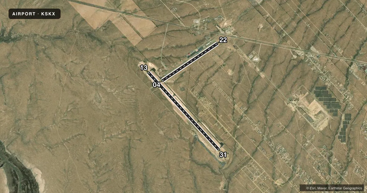
Runways & pattern
Full pagePattern entry · RWY 13
LEFT TRAFFIC| Runway | Heading (°M) | Length | Surface | Traffic |
|---|---|---|---|---|
| 13/31 | 128° / 308° | 8,600 ft | CONC | Standard L |
| 04/22 | 47° / 227° | 5,504 ft | ASPH | Standard L |
Runway end performance
| End | TORA | TODA | ASDA | LDA | VGSI | Approach lights | Obstruction |
|---|---|---|---|---|---|---|---|
| 13 | — | — | — | — | PAPI 4-box left(3°) | — | — |
| 31 | — | — | — | — | PAPI 4-box left(3°) | — | — |
| 04 | — | — | — | — | PAPI 4-box left(3°) | — | — |
| 22 | — | — | — | — | PAPI 4-box left(3°) | — | — |
Declared distances in feet. TORA = takeoff run available, TODA = takeoff distance, ASDA = accelerate-stop, LDA = landing distance.
Airport sketch
Runways drawn to scale from FAA survey coordinates, rendered over satellite imagery. Not for navigation.
Approaches & charts
Services on the field
Fuel grades, oxygen, maintenance, ramp storage and lighting — as declared to the FAA by the airport operator.
Fuel & services
- Fuel
- 100LLA1+
- Airframe repair
- Minor
- Power plant repair
- Minor
- Other services
- AMB,INSTR
Ramp & ground
- Transient storage
- Tie-down
- Hangar
- Landing fee
- No fee published
- Customs
- Not available
- Lighting schedule
- SEE RMK
- Beacon schedule
- SS-SR
- Beacon
- White / Green (civil land)(WG)
- Wind indicator
- Lighted
- Segmented circle
- Yes
Fuel & FBOs
Cheapest 100LL and Jet A on the field and nearby. Always confirm with the FBO before taxi.
Airport notes
Surface conditions, obstructions, local procedures, lighting outages and other notes published with each FAA cycle.
General notes
- AVOID OVERFLIGHT OF TAOS PUEBLO WORLD HERITAGE SITE 5 NM EAST OF ARPT.
- RWY 04/22 PARALLEL TWY HAS RETRO-REFLECTORS.
- WILDLIFE INVOF ARPT.
- FOR CD IF UNA TO CTC ON FSS FREQ, CTC ALBUQUERQUE ARTCC AT 505-856-4561.
Lighting notes
- ACTVT REIL RWY 04, 13, 31; PAPI RWY 04, 13, 22, 31; MIRL RWY 04/22, 13/31 - CTAF.
Fuel notes
- 100LLFOR AFT HRS FUEL SVC CALL 575-758-5436. AFT HRS CALLOUT FEE CHARGED FOR JET A.
Runway surface & condition
- 04/22RWY 04: 150 FT BLAST PAD. RWY 22: 250 FT BLAST PAD.
- 13/31RWY 13: 150 FT BLAST PAD. RWY 31: 150 FT BLAST PAD.
Other notes
- THIS AIRPORT HAS BEEN SURVEYED BY THE NATIONAL GEODETIC SURVEY.
- MANAGERPHYSICAL ADDRESS 24662 HWY 64, EL PRADO NM 87529
- MANAGEREMER FONE: 575-770-1699 (CELL).
VFR map & nearby airports
VFR sectional. Tap any ICAO chip to open that airport.
Key facts · KSKX
Answer card- ICAO
- KSKX
- Name
- TAOS RGNL
- Location
- TAOS, NEW MEXICO
- Elevation
- 7,094.6 ft MSL
- Traffic pattern altitude
- 8,094.6 ft MSL (1,000 AGL)
- Control tower
- Non-towered (use CTAF)
- Total runways
- 2
- Longest runway
- 13/31 · 8,600 ft
- Published ILS approaches
- 0
- Published frequencies
- 2
- Magnetic variation
- 9°
- Current flight rules
- VFR
- Current wind
- 000° at 0 kt
- Favored runway now
- –
Taos Regional Airport sits in Taos, New Mexico at 7,094.6 ft MSL. It has two runways. Runway 13/31 is the longest at 8,600 ft. Runway 04/22 is 5,504 ft. The field is non-towered. CTAF and UNICOM are both 122.8. No ILS approaches are published here.
Pattern altitude is not published. Use the standard 1,000 ft AGL for light piston traffic unless the current Chart Supplement or local procedures say otherwise. That puts the light-aircraft pattern at about 8,095 ft MSL. This is a high-elevation airport, so expect performance to be a bigger factor than it is at lower fields. Watch density altitude closely, especially on warm days.
Taos Aviation Services is on the field. It carries 100LL and Jet A Prist. The published remarks also note wildlife in the area. Avoid overflight of Taos Pueblo World Heritage Site, which is 5 NM east of the airport. Runway lighting is published for both runways. PAPI is available on 04, 13, 22 and 31. If you need after-hours fuel help, the remarks list a phone number for that service. For clearance delivery when FSS is not available, contact Albuquerque ARTCC. Use the current Chart Supplement for any changes before you go.