METAR & TAF KRCE
Current METAR
Observed 20:35Z
KRCE 252035Z AUTO 22008G15KT 10SM FEW060 38/21 A2998 RMK AO2
- Wind
- 220° @ 8G15 kt
- Visibility
- 10 SM
- Temp / Dew
- 38°C / 21°C
- Altimeter
- 29.98 inHg
- Clouds
- FEW
- Density alt
- 4,364 ft
- Ceiling
- Unlimited
- Rules
- VFR
Airport info & contacts
Manager on record, flight service, ARTCC, attendance schedule and pattern altitude — published by the FAA and refreshed every 28 days.
Location
- From city
- 15 NM W
- VFR sectional
- DALLAS-FT WORTH
- ARTCC
- ZFW · FORT WORTH
- NOTAM facility
- MLC (NOTAM-D)
Airport manager
- Name
- KRISTY SLATER
- Phone
- 405-316-4061
- Address
- 5915 PHILLIP J. RHOADES RM 104, BETHANY OK 73008
Flight service · Hours
- FSS MLC
- MC ALESTER1-800-WX-BRIEF
- Attendance
- MON-SAT · 0730-1730
Frequencies
Tap any row to copy the frequency to your clipboard.
Runways & pattern
Full pagePattern entry · RWY 17R
RIGHT TRAFFIC| Runway | Heading (°M) | Length | Surface | Traffic |
|---|---|---|---|---|
| 17R/35LFavored | 173° / 353° | 6,014 ft | CONC | 17R R |
| 17L/35R | 173° / 353° | 3,502 ft | CONC | 35R R |
Runway end performance
| End | TORA | TODA | ASDA | LDA | VGSI | Approach lights | Obstruction |
|---|---|---|---|---|---|---|---|
| 17R | — | — | — | — | PAPI 4-box left(3°) | — | 10', other, 255' from thr, 231' R of cntrln, slope 5 |
| 35L | — | — | — | — | PAPI 4-box left(3°) | — | 26', trees, 850' from thr, 330' R of cntrln, slope 25 |
Declared distances in feet. TORA = takeoff run available, TODA = takeoff distance, ASDA = accelerate-stop, LDA = landing distance.
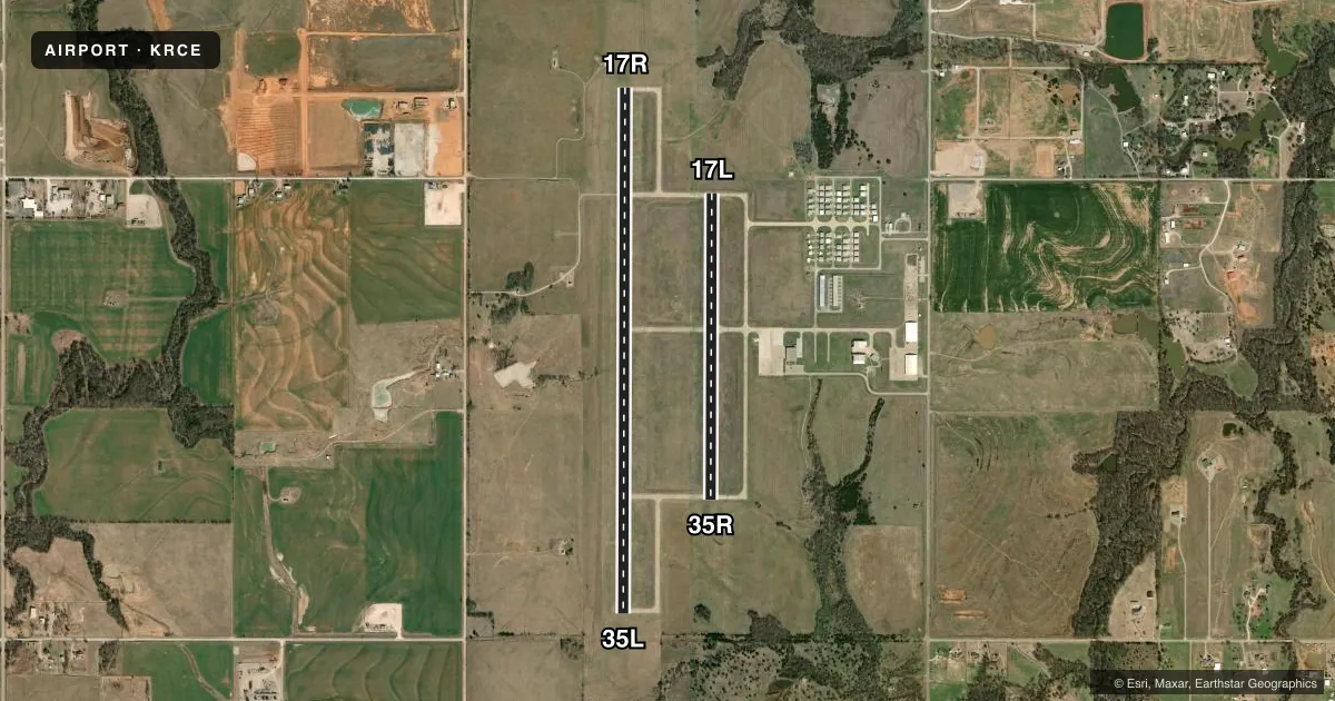
Airport sketch
Runways drawn to scale from FAA survey coordinates, rendered over satellite imagery. Not for navigation.
Approaches & charts
Services on the field
Fuel grades, oxygen, maintenance, ramp storage and lighting — as declared to the FAA by the airport operator.
Fuel & services
- Fuel
- 100LLA+
- Oxygen (bottled)
- High pressure
- Oxygen (bulk)
- Not available
- Airframe repair
- Major
- Power plant repair
- Major
Ramp & ground
- Transient storage
- Tie-down
- Landing fee
- No fee published
- Customs
- Not available
- Lighting schedule
- SEE RMK
- Beacon schedule
- SS-SR
- Beacon
- White / Green (civil land)(WG)
- Wind indicator
- Lighted
- Segmented circle
- Yes
Fuel & FBOs
Cheapest 100LL and Jet A on the field and nearby. Always confirm with the FBO before taxi.
Airport notes
Surface conditions, obstructions, local procedures, lighting outages and other notes published with each FAA cycle.
General notes
- DEER ON & INVOF RY.
- AEROBATIC ACFT BLO 6400 FT 1 NM RADIUS OF ARPT.
- SFC CONDS RPTD MON-FRI 0800-1700.
- FOR CD CTC OKE CITY APCH AT 405-681-5683.
Lighting notes
- DUSK-DAWN. ACTVT HIRL RY 17R/35L & MIRL 17L/35R - CTAF.
Approach & departure obstructions
- 17ROIL WELL.
Other notes
- THIS AIRPORT HAS BEEN SURVEYED BY THE NATIONAL GEODETIC SURVEY.
- PRE DATES THE ACT.
VFR map & nearby airports
VFR sectional. Tap any ICAO chip to open that airport.
Key facts · KRCE
Answer card- ICAO
- KRCE
- Name
- CLARENCE E PAGE MUNI
- Location
- OKLAHOMA CITY, OKLAHOMA
- Elevation
- 1,353.8 ft MSL
- Traffic pattern altitude
- 2,353.8 ft MSL (1,000 AGL)
- Control tower
- Non-towered (use CTAF)
- Total runways
- 2
- Longest runway
- 17R/35L · 6,014 ft
- Published ILS approaches
- 0
- Published frequencies
- 4
- Magnetic variation
- 7°
- Current flight rules
- VFR
- Current wind
- 220° at 8 kt
- Favored runway now
- RWY 17R
Clarence E Page Muni is in Oklahoma City, Oklahoma. Field elevation is 1,353.8 ft MSL. The airport has two concrete runways. The longest is 17R/35L at 6,014 ft. There is no control tower. No ILS approaches are published here.
Pattern altitude is not published. Use the standard 1,000 ft AGL for light piston traffic unless local guidance says otherwise. That puts the traffic pattern at about 2,354 ft MSL. Legacy Aviation Services is on the field. It carries 100LL and Jet A Prist. Deer are reported on and near the runway. There is also an oil well near runway 17R, so pay attention on the south side of the field.
Runway lighting is useful at night. From dusk to dawn, high intensity lights are activated on 17R/35L by CTAF. Medium intensity lights are used on 17L/35R by CTAF. The airport also reports surface conditions Monday through Friday from 0800 to 1700. For clearance delivery, contact Oke City Approach at 405-681-5683. Expect busy local traffic. Aerobatic aircraft operate below 6,400 ft within 1 NM of the airport.