METAR & TAF KPRX
Current METAR
Observed 12:55Z
KPRX 271255Z AUTO 18006KT 10SM CLR 27/22 A2997 RMK AO2 SLP142 T02670222
- Wind
- 180° @ 6 kt
- Visibility
- 10 SM
- Temp / Dew
- 27°C / 22°C
- Altimeter
- 29.97 inHg
- Clouds
- CLR
- Density alt
- 2,057 ft
- Ceiling
- Unlimited
- Rules
- VFR
Airport info & contacts
Manager on record, flight service, ARTCC, attendance schedule and pattern altitude — published by the FAA and refreshed every 28 days.
Location
- From city
- 6 NM E
- VFR sectional
- DALLAS-FT WORTH
- ARTCC
- ZFW · FORT WORTH
- NOTAM facility
- PRX (NOTAM-D)
Airport manager
- Name
- THOMAS HERNDON
- Phone
- 903-784-4648
- Address
- 6780 COLLIER DR, PARIS TX 75462
Flight service · Hours
- FSS FTW
- FORT WORTH1-800-WX-BRIEF
- Attendance
- MON-SAT · 0800-1700
Frequencies
Tap any row to copy the frequency to your clipboard.
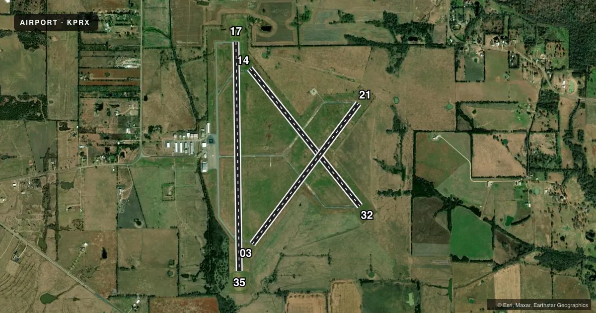
Runways & pattern
Full pagePattern entry · RWY 17
LEFT TRAFFIC| Runway | Heading (°M) | Length | Surface | Traffic |
|---|---|---|---|---|
| 17/35Favored | 175° / 355° | 6,002 ft | ASPH | Standard L |
| 03/21 | 33° / 213° | 4,624 ft | CONC | Standard L |
| 14/32 | 137° / 317° | 4,624 ft | CONC | Standard L |
Runway end performance
| End | TORA | TODA | ASDA | LDA | VGSI | Approach lights | Obstruction |
|---|---|---|---|---|---|---|---|
| 17 | 6,002' | 6,002' | 6,002' | 6,002' | PAPI 4-box left(3°) | — | — |
| 35 | 6,002' | 6,002' | 6,002' | 6,002' | PAPI 4-box left(3°) | — | 37', trees, 325' from thr, 260' R of cntrln, slope 3 |
| 03 | 4,624' | 4,624' | 4,624' | 4,624' | — | — | 28', trees, 860' from thr, 185' R of cntrln, slope 23 |
| 21 | 4,624' | 4,624' | 4,624' | 4,624' | — | — | 18', trees, 407' from thr, 135' R of cntrln, slope 11 |
| 14 | 4,624' | 4,624' | 4,624' | 4,624' | — | — | 30', trees, 455' from thr, 245' R of cntrln, slope 8 |
| 32 | 4,624' | 4,624' | 4,624' | 4,624' | — | — | — |
Declared distances in feet. TORA = takeoff run available, TODA = takeoff distance, ASDA = accelerate-stop, LDA = landing distance.
Airport sketch
Runways drawn to scale from FAA survey coordinates, rendered over satellite imagery. Not for navigation.
Approaches & charts
Services on the field
Fuel grades, oxygen, maintenance, ramp storage and lighting — as declared to the FAA by the airport operator.
Fuel & services
- Fuel
- 100LLA
- Oxygen (bottled)
- Not available
- Oxygen (bulk)
- Not available
- Airframe repair
- Minor
- Power plant repair
- Minor
- Other services
- AGRI,INSTR,RNTL
Ramp & ground
- Transient storage
- Tie-down
- Landing fee
- No fee published
- Customs
- Not available
- Lighting schedule
- SEE RMK
- Beacon schedule
- SS-SR
- Beacon
- White / Green (civil land)(WG)
- Wind indicator
- Lighted
- Segmented circle
- Yes
Fuel & FBOs
Cheapest 100LL and Jet A on the field and nearby. Always confirm with the FBO before taxi.
Airport notes
Surface conditions, obstructions, local procedures, lighting outages and other notes published with each FAA cycle.
General notes
- RWYS 03/21 & 14/32 NOT AVBL FOR ACR OPNS WITH MORE THAN 30 PSGR SEATS.
- TWY LGTS FROM TRML APRON TO RWY 17/35 ON MIDFIELD TWY ONLY.
- RWY 14/32 NO LINE OF SIGHT BTN RWY ENDS.
- FOR CD IF UNA TO CTC ON FSS FREQ, CTC FORT WORTH ARTCC AT 817-858-7584.
Lighting notes
- MIRL RWY 17/35 PRESET LOW INTST DUSK-DAWN; TO INCR INTST ACTVT - CTAF. PAPI RWYS 17 & 35 OPRS CONSLY.
Fuel notes
- 100LL100LL AVBL 24 HR SELF SERVE. FOR JET AFTR HRS, CALL 903-784-4648.
Approach & departure obstructions
- 1410 FT BRUSH, 30 FT DSTC, 244 FT L.
- 1739 FT TREES, 100 FT DSTC, 390 FT L.
- 2140 FT TREES 132 FT DSTC, 245 FT L
- 3520 FT TREES, 0-199 FT DSTC, 250 L.
- 03MKGS FADED.
- 21MKGS FADED.
- H1APPROACH RATIO 5:1; 28 FT TREES 178 FT WEST
Other notes
- THIS AIRPORT HAS BEEN SURVEYED BY THE NATIONAL GEODETIC SURVEY.
- MANAGERTHERNDON@PARISTEXAS.GOV
- 03/21RWY COND NOT MNTND. VEGETATION GROWING THROUGH CRACKS.
VFR map & nearby airports
VFR sectional. Tap any ICAO chip to open that airport.
Key facts · KPRX
Answer card- ICAO
- KPRX
- Name
- COX FLD
- Location
- PARIS, TEXAS
- Elevation
- 547.6 ft MSL
- Traffic pattern altitude
- 1,547.6 ft MSL (1,000 AGL)
- Control tower
- Non-towered (use CTAF)
- Total runways
- 3
- Longest runway
- 17/35 · 6,002 ft
- Published ILS approaches
- 0
- Published frequencies
- 2
- Magnetic variation
- 4°
- Current flight rules
- VFR
- Current wind
- 180° at 6 kt
- Favored runway now
- RWY 17
Cox Field sits in Paris, Texas. The field elevation is 547.6 ft MSL. It has three runways. The longest is runway 17/35 at 6,002 ft. There is no control tower, so expect self-announce traffic on CTAF 122.975. No ILS approaches are published here.
Pattern altitude is not published. Use the standard 1,000 ft AGL pattern for light piston aircraft unless the current Chart Supplement or local traffic calls for something different. Runway 17/35 has medium intensity lights that come up low from dusk to dawn. You can increase intensity by keying the CTAF. PAPI is available on runways 17 and 35 and runs continuously. Cox Field FBO is on the field. It carries 100LL and Jet A Prist. 100LL is available 24 hours self-serve. For Jet A after hours, call the FBO.
A few runway details matter here. Runway 03/21 is not maintained. Vegetation is growing through cracks. Runways 03/21 and 14/32 are not available for aircraft with more than 30 passenger seats. Runway 14/32 also has no line of sight between the ends. There are tree obstructions near the ends of runways 35, 17 and 14. If you are planning a first visit, brief the runway lighting. Brief the non-towered pattern. Brief the runway condition before you go.