METAR & TAF KPMP
Current METAR
Observed 16:03Z
KPMP 271603Z 27007KT 10SM SCT030 SCT037 32/24 A2996 RMK AO2 T03220239
- Wind
- 270° @ 7 kt
- Visibility
- 10 SM
- Temp / Dew
- 32°C / 24°C
- Altimeter
- 29.96 inHg
- Clouds
- SCT
- Density alt
- 2,014 ft
- Ceiling
- Unlimited
- Rules
- VFR
Airport info & contacts
Manager on record, flight service, ARTCC, attendance schedule and pattern altitude — published by the FAA and refreshed every 28 days.
Location
- From city
- 1 NM NE
- VFR sectional
- MIAMI
- Pattern altitude
- 800 ft AGL · 819 ft MSL
- ARTCC
- ZMA · MIAMI
- NOTAM facility
- PMP (NOTAM-D)
Airport manager
- Name
- STEVEN ROCCO
- Phone
- 954-786-4135
- Address
- POMPANO BEACH AIRPARK, 1001 NORTHEAST 10TH STREET, POMPANO BEACH FL 33060
Flight service · Hours
- FSS MIA
- MIAMI1-800-WX-BRIEF
- Attendance
- 0700-1900
Frequencies
Tap any row to copy the frequency to your clipboard.
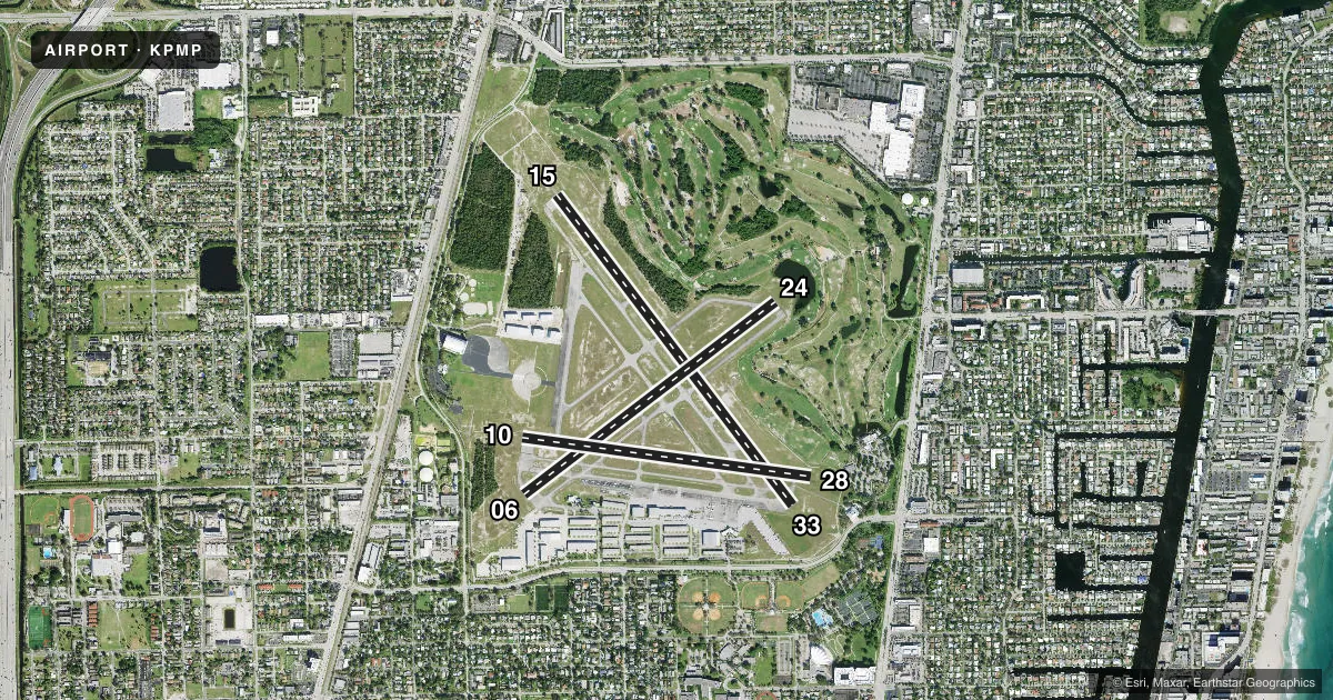
Runways & pattern
Full pagePattern entry · RWY 28
LEFT TRAFFIC| Runway | Heading (°M) | Length | Surface | Traffic |
|---|---|---|---|---|
| 15/33 | 136° / 316° | 4,918 ft | ASPH | Standard L |
| 06/24 | 46° / 226° | 4,001 ft | ASPH | Standard L |
| 10/28Favored | 91° / 271° | 3,687 ft | ASPH | Standard L |
Runway end performance
| End | TORA | TODA | ASDA | LDA | VGSI | Approach lights | Obstruction |
|---|---|---|---|---|---|---|---|
| 15 | — | — | — | — | PAPI 4-box left(3°) | MALS | 48', pline, 1815' from thr, 275' R of cntrln, slope 33 |
| 33 | — | — | — | — | PAPI 4-box left(3°) | — | 42', trees, 1260' from thr, 300' R of cntrln, slope 25 |
| 06 | — | — | — | — | PAPI 2-box left(3.75°) | — | 40', trees, 845' from thr, 225' R of cntrln, slope 16 |
| 24 | — | — | — | — | PAPI 2-box left(3.5°) | — | 59', trees, 1395' from thr, 150' R of cntrln, slope 20 |
| 10 | — | — | — | — | PAPI 2-box left(3.75°) | — | 37', tree, 925' from thr, 90' R of cntrln, slope 19 |
| 28 | — | — | — | — | PAPI 2-box left(3.9°) | — | 25', trees, 410' from thr, 105' R of cntrln, slope 8 |
Declared distances in feet. TORA = takeoff run available, TODA = takeoff distance, ASDA = accelerate-stop, LDA = landing distance.
Airport sketch
Runways drawn to scale from FAA survey coordinates, rendered over satellite imagery. Not for navigation.
Approaches & charts
ILS · 1
Services on the field
Fuel grades, oxygen, maintenance, ramp storage and lighting — as declared to the FAA by the airport operator.
Fuel & services
- Fuel
- 100LLA
- Oxygen (bottled)
- HIGH/LOW
- Oxygen (bulk)
- HIGH/LOW
- Airframe repair
- Major
- Power plant repair
- Major
- Other services
- AMB,AVNCS,CHTR,INSTR,RNTL,SALES
Ramp & ground
- Transient storage
- Tie-down
- Hangar
- Landing fee
- No fee published
- Customs
- Not available
- Lighting schedule
- SEE RMK
- Beacon schedule
- SS-SR
- Beacon
- White / Green (civil land)(WG)
- Wind indicator
- Lighted
- Segmented circle
- No
Fuel & FBOs
Cheapest 100LL and Jet A on the field and nearby. Always confirm with the FBO before taxi.
Airport notes
Surface conditions, obstructions, local procedures, lighting outages and other notes published with each FAA cycle.
General notes
- NMRS BIRDS ON & INVOF ARPT.
- ALL RWYS NOISE SENSITIVE ALL QUADRANTS; CTC AMGR FOR HEL & FIXED WING OPS. TGL OPNS PMTD MON-FRI 0900-1800 AND LTD AS POSS ON WKENDS AND LEGAL HOLS. STOP AND GO OPNS AND INTERSECTION TKOFS STGLY DISCOURAGED AT ALL TIMES.
- FOR CD WHEN ATCT CLSD CTC MIAMI APCH AT 305-869-5432.
- ACFT WITH GWT MORE THAN 30000 LBS PPR ON RWY 15/33. ACFT EXCEEDING 12500 PROHIBITED ON RWY 10/28.
Lighting notes
- REIL RWY 06 & 24, 33; PAPI RWY 10 & 28 OPR DUSK TO DAWN. WHEN ATCT CLSD ACTVT MALS RWY 15 - CTAF. MIRL RWY 15/33 & RWY MOST ALIGNED TO WIND PRESET MED INTST ONLY.
Runway surface & condition
- 06/24LTD TO GWT 12500 LBS OR LESS.
- 10/28LTD TO GWT 12500 LBS OR LESS.
- 15/33LTD TO GWT 30000 LBS OR LESS.
Approach & departure obstructions
- 10RWY 28 APRCH SLOPE 24:1 TO DISP T-HOLD.
- 15APCH SLOPE 48:1 TO DSPLCD THR.
- 33APCH SLP 37:1 TO DTHR.
Other notes
- BELL HEL SVC CTR ON ARPT.
VFR map & nearby airports
VFR sectional. Tap any ICAO chip to open that airport.
Key facts · KPMP
Answer card- ICAO
- KPMP
- Name
- POMPANO BEACH AIRPARK
- Location
- POMPANO BEACH, FLORIDA
- Elevation
- 19.3 ft MSL
- Traffic pattern altitude
- 819.3 ft MSL (800 AGL)
- Control tower
- Towered · 0700-2100
- Total runways
- 3
- Longest runway
- 15/33 · 4,918 ft
- Published ILS approaches
- 1
- Published frequencies
- 7
- Magnetic variation
- 7°
- Current flight rules
- VFR
- Current wind
- 270° at 7 kt
- Favored runway now
- RWY 28
Pompano Beach Airpark sits in Pompano Beach, Florida. Field elevation is 19.3 ft MSL. The airport has three asphalt runways. The longest is runway 15/33 at 4,918 ft. The field is towered from 0700 to 2100. One ILS is published for runway 15. Pattern altitude is 800 ft AGL, which is 819.3 ft MSL.
This is a busy South Florida field with noise-sensitive operations in all quadrants. Touch-and-go work is allowed Monday through Friday from 0900 to 1800. It is limited as much as possible on weekends and legal holidays. Stop-and-go work and intersection departures are strongly discouraged. Runway 15 has a building close to the approach end. The published notes also call out numerous birds in and around the airport. That matters on departure and in the pattern.
Pompano Aviation is on the field. It carries 100LL and Jet A Prist. Sheltair is also on the field. It carries 100LL, Jet A and Jet A Prist. Bell helicopter service center is on the airport as well. Runway 15/33 is limited to 30,000 lb gross weight or less. Runway 06/24 and runway 10/28 are limited to 12,500 lb gross weight or less. When the tower is closed, clearance delivery comes from Miami Approach. Check the current FAA Chart Supplement for any noise or curfew restrictions before flying in.