METAR & TAF KOJC
Current METAR
Observed 22:53Z
KOJC 272253Z 21008KT 10SM CLR 36/22 A2980 RMK AO2 SLP075 T03610222 PNO
- Wind
- 210° @ 8 kt
- Visibility
- 10 SM
- Temp / Dew
- 36°C / 22°C
- Altimeter
- 29.80 inHg
- Clouds
- CLR
- Density alt
- 4,028 ft
- Ceiling
- Unlimited
- Rules
- VFR
Airport info & contacts
Manager on record, flight service, ARTCC, attendance schedule and pattern altitude — published by the FAA and refreshed every 28 days.
Location
- From city
- 4 NM SE
- VFR sectional
- KANSAS CITY
- Pattern altitude
- 1,000 ft AGL · 2,096 ft MSL
- ARTCC
- ZKC · KANSAS CITY
- NOTAM facility
- OJC (NOTAM-D)
Airport manager
- Name
- BRYAN JOHNSON
- Phone
- 913-715-6002
- Address
- ONE NEW CENTURY PARKWAY, NEW CENTURY KS 66031
Flight service · Hours
- FSS COU
- COLUMBIA1-800-WX-BRIEF
- Attendance
- ALL
Frequencies
Tap any row to copy the frequency to your clipboard.
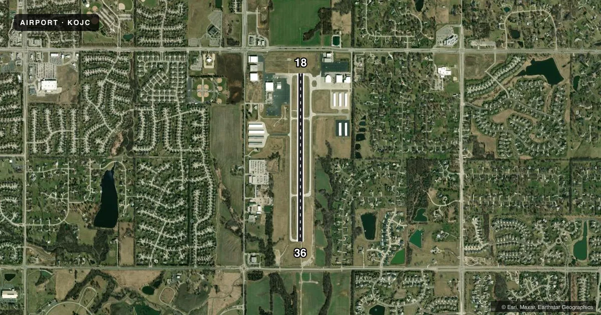
Runways & pattern
Full pagePattern entry · RWY 18
LEFT TRAFFICRunway end performance
| End | TORA | TODA | ASDA | LDA | VGSI | Approach lights | Obstruction |
|---|---|---|---|---|---|---|---|
| 18 | 4,097' | 4,097' | 4,097' | 4,097' | PAPI 4-box right(3°) | — | — |
| 36 | 4,097' | 4,097' | 4,097' | 4,097' | VASI 2-box left(3°) | MALSR | 34', trees, 835' from thr, 200' R of cntrln, slope 18 |
Declared distances in feet. TORA = takeoff run available, TODA = takeoff distance, ASDA = accelerate-stop, LDA = landing distance.
Airport sketch
Runways drawn to scale from FAA survey coordinates, rendered over satellite imagery. Not for navigation.
Approaches & charts
ILS · 2
Services on the field
Fuel grades, oxygen, maintenance, ramp storage and lighting — as declared to the FAA by the airport operator.
Fuel & services
- Fuel
- 100LLA
- Oxygen (bottled)
- Low pressure
- Oxygen (bulk)
- Low pressure
- Airframe repair
- Major
- Power plant repair
- Major
- Other services
- AMB,AVNCS,CHTR,INSTR,RNTL,SALES
Ramp & ground
- Transient storage
- Tie-down
- Hangar
- Landing fee
- No fee published
- Customs
- Not available
- Lighting schedule
- SEE RMK
- Beacon schedule
- SS-SR
- Beacon
- White / Green (civil land)(WG)
- Wind indicator
- Lighted
- Segmented circle
- No
Fuel & FBOs
Cheapest 100LL and Jet A on the field and nearby. Always confirm with the FBO before taxi.
Airport notes
Surface conditions, obstructions, local procedures, lighting outages and other notes published with each FAA cycle.
General notes
- UPON TAKEOFF FOR RYS 18 & 36 MAINTAIN RY HEADING UNTIL PASSING 1,600 FT MSL.
- BIRDS, WATERFOWL, WILDLIFE ON & INVOF ARPT.
- TO CONFIRM SNOW REMOVAL AND WINTER CONDITIONS NOV-APR CALL 913-715-6005.
- FOR CD WHEN ATCT IS CLSD CTC MCI APCH AT 816-329-2710.
- IT IS ADVISED THAT ROTOCRAFT AVOID THE OVERFLIGHTS OF SURROUNDING NEIGHBORHOODS.
Lighting notes
- WHEN TWR CLSD ACTVT MALSR RWY 36, MIRL RWY 18-36, TWY LGTS AND WIND CONE - CTAF.
Runway surface & condition
- 18/36PCR VALUE: 90/R/D/W/T
Other notes
- HEL CONDS: PROVDD APCH/DEP PATHS TO LNDG AREA MAINTD FOR MIN 8:1 GLIDE SLOPE & TRSNL SFC BE MAINTD FOR 2:1 SLOPE.
- TPA LOW PER ACFT 1000 FT AGL, HIGH PER ACFT 1500 FT AGL
VFR map & nearby airports
VFR sectional. Tap any ICAO chip to open that airport.
Key facts · KOJC
Answer card- ICAO
- KOJC
- Name
- JOHNSON COUNTY EXEC
- Location
- OLATHE, KANSAS
- Elevation
- 1,096.3 ft MSL
- Traffic pattern altitude
- 2,096.3 ft MSL (1,000 AGL)
- Control tower
- Towered · 0700-2100
- Total runways
- 1
- Longest runway
- 18/36 · 4,097 ft
- Published ILS approaches
- 2
- Published frequencies
- 8
- Magnetic variation
- 4°
- Current flight rules
- VFR
- Current wind
- 210° at 8 kt
- Favored runway now
- RWY 18
Johnson County Executive Airport is in Olathe, Kansas. The field elevation is 1,096.3 ft MSL. It has one runway, 18/36, which is 4,097 ft long. The airport is towered from 0700 to 2100. Two ILS approaches are published for runway ends 18 and 36. Pattern altitude is 1,000 ft AGL, which is 2,096.3 ft MSL for the low pattern. The high pattern is 1,500 ft AGL.
This is a busy metro airport, so expect controlled traffic flow and stay sharp on tower instructions. When the tower is closed, medium intensity approach lights with runway alignment indicator lights are available for runway 36. Medium intensity runway lights are available for 18/36. Taxiway lights and the wind cone are on CTAF. For clearance delivery when the tower is closed, contact MCI Approach.
KCAC Aviation is on the field. Executive Aircraft Service is also on the field. Both carry 100LL and Jet A. Published remarks also note wildlife in the area, so watch for birds on taxi and in the pattern. After takeoff on 18 or 36, maintain runway heading until passing 1,600 ft MSL. Rotorcraft should avoid overflying surrounding neighborhoods.