METAR & TAF KMKC
Current METAR
Observed 21:54Z
KMKC 272154Z 20015G21KT 10SM CLR 38/21 A2976 RMK AO2 PK WND 21026/2136 SLP065 T03780211
- Wind
- 200° @ 15G21 kt
- Visibility
- 10 SM
- Temp / Dew
- 38°C / 21°C
- Altimeter
- 29.76 inHg
- Clouds
- CLR
- Density alt
- 3,897 ft
- Ceiling
- Unlimited
- Rules
- VFR
Airport info & contacts
Manager on record, flight service, ARTCC, attendance schedule and pattern altitude — published by the FAA and refreshed every 28 days.
Location
- From city
- 0 NM NW
- VFR sectional
- KANSAS CITY
- ARTCC
- ZKC · KANSAS CITY
- NOTAM facility
- MKC (NOTAM-D)
Airport manager
- Name
- ROD DEWINKLER
- Phone
- 816-859-7610
- Address
- 900 NW RICHARDS ROAD, KANSAS CITY MO 64116
Flight service · Hours
- FSS COU
- COLUMBIA1-800-WX-BRIEF
- Attendance
- ALL
Frequencies
Tap any row to copy the frequency to your clipboard.
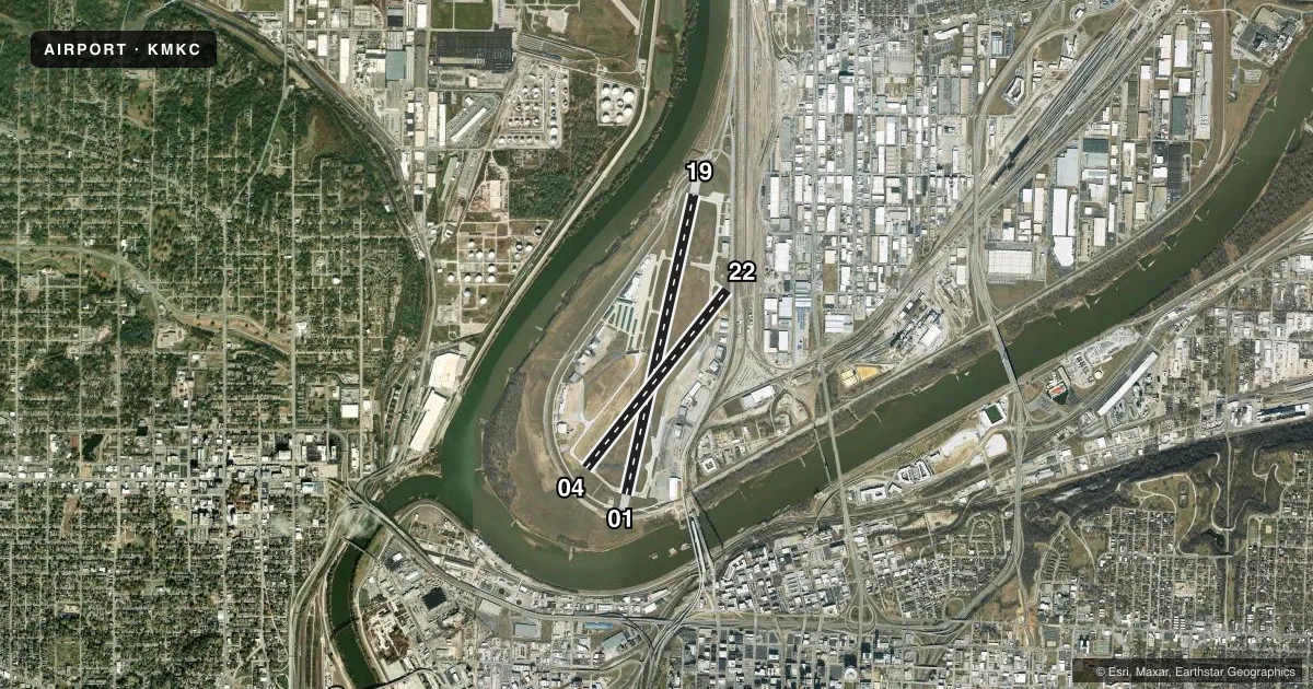
Runways & pattern
Full pagePattern entry · RWY 19
LEFT TRAFFIC| Runway | Heading (°M) | Length | Surface | Traffic |
|---|---|---|---|---|
| 01/19Favored | 12° / 192° | 6,827 ft | CONC | Standard L |
| 04/22 | 37° / 217° | 5,050 ft | ASPH | Standard L |
Runway end performance
| End | TORA | TODA | ASDA | LDA | VGSI | Approach lights | Obstruction |
|---|---|---|---|---|---|---|---|
| 01 | 6,827' | 6,827' | 6,827' | 6,528' | VASI 4-box left(3.7°) | RLLS | 38', tree, 747' from thr, 571' R of cntrln, slope 20 |
| 19 | 6,827' | 6,827' | 6,827' | 6,526' | PAPI 4-box left(3°) | MALSF | 20', road, 700' from thr, 150' R of cntrln, slope 25 |
| 04 | 5,050' | 5,050' | 4,770' | 4,270' | VASI 4-box left(3°) | — | 20', berm, 450' from thr, 125' R of cntrln, slope 12 |
| 22 | 5,050' | 5,050' | 5,050' | 4,351' | VASI 4-box left(3.3°) | — | 37', rr, 225' from thr, 100' R of cntrln, slope 0 |
Declared distances in feet. TORA = takeoff run available, TODA = takeoff distance, ASDA = accelerate-stop, LDA = landing distance.
Airport sketch
Runways drawn to scale from FAA survey coordinates, rendered over satellite imagery. Not for navigation.
Approaches & charts
ILS · 2
Services on the field
Fuel grades, oxygen, maintenance, ramp storage and lighting — as declared to the FAA by the airport operator.
Fuel & services
- Fuel
- 100LLA
- Oxygen (bottled)
- HIGH/LOW
- Oxygen (bulk)
- HIGH/LOW
- Airframe repair
- Major
- Power plant repair
- Major
- Other services
- AFRT,AVNCS,CARGO,CHTR,INSTR,RNTL,SALES,SURV
Ramp & ground
- Transient storage
- Tie-down
- Hangar
- Landing fee
- No fee published
- Customs
- Not available
- Lighting schedule
- SS-SR
- Beacon schedule
- SS-SR
- Beacon
- White / Green (civil land)(WG)
- Wind indicator
- Lighted
- Segmented circle
- No
Fuel & FBOs
Cheapest 100LL and Jet A on the field and nearby. Always confirm with the FBO before taxi.
Airport notes
Surface conditions, obstructions, local procedures, lighting outages and other notes published with each FAA cycle.
General notes
- WILDLIFE ON & INVOF ARPT.
- FLOCKS OF PIGEONS INVOF DEP EOR 04.
- RWY 04/22 VFR E TFC PAT: DEPARTING RWY 04 RIGHT TFC ATTAIN TFC PAT ALT PRIOR TO TURNING CROSSWIND. LDG RWY 22 MNTN TFC PAT ALT UNTIL PASSING N OF MISSOURI RIVER.
- ATCT HAS LIMITED VISIBILITY OF T-HANGAR APRONS N TWY D AND W TWY L .
- FAA SAFETY VIDEO CAN BE ACCESSED AT HTTPS://WWW.FAA.GOV/AIRPORTS/RUNWAY_SAFETY/VIDEOS/MKC/
- CTN: MULT OBSTRUCTIONS 0.5 MI-1.0 MI ESE FM RWY 19 DER UP TO 290 FT AGL/1100 FT MSL.
- DUE TO OBSTNS, PRIOR TO ANY TURNS TO THE E, ACFT MUST BE AT OR ABV TFC PTN ALT
Fuel notes
- 100LL100LL SELF SVC AVBL 24 HRS WITH CREDIT CARD ONLY ON WEST SIDE NEAR GA TERMINAL.
Runway surface & condition
- 01/19PCR VALUE: 784/R/D/W/T
- 04/22PCR VALUE: 560/F/C/X/T
Approach & departure obstructions
- 19RY19 MALSF AUGMENTED WITH RAIL.
- 19ROAD & FENCE 0-200' FM THR.
- 22ROAD & RR 0-200' FM THR.
- 22UNUSBL BYD 8 DEGS LEFT OF CRS.
- 04APCH RATIO AT DSPLCD THR 47:1.
- 22APCH RATIO AT DSPLCD THR 24:1.
Arresting gear
- 01_EMASENGINEERED MATERIALS ARRESTING SYSYTEM (EMAS) 263 FT IN LENGTH BY 170 FT IN WIDTH LCTD AT THE DER 01.
- 19_EMASENGINEERED MATERIALS ARRESTING SYSYTEM (EMAS) 287 FT IN LENGTH BY 170 FT IN WIDTH LCTD AT THE DER 19.
Other notes
- ARPT CLSD TO ACR OPNS WITH MORE THAN 30 PSGR SEATS EXCP 24 HR PPR CALL AMGR (816) 289-2718. AIR CARRIER OPS NOT AUTHORIZED IN EXCESS OF 15 MINUTES BFR OR AFT SKED ARR OR DEP TIMES W/O PRIOR COORDINATION WITH AMGR CONFIRMING ARFF AVBL PRIOR TO LNDG OR TKOF.
VFR map & nearby airports
VFR sectional. Tap any ICAO chip to open that airport.
Key facts · KMKC
Answer card- ICAO
- KMKC
- Name
- KANSAS CITY DOWNTOWN/WHEELER FLD
- Location
- KANSAS CITY, MISSOURI
- Elevation
- 756.9 ft MSL
- Traffic pattern altitude
- 1,756.9 ft MSL (1,000 AGL)
- Control tower
- Towered · 24
- Total runways
- 2
- Longest runway
- 01/19 · 6,827 ft
- Published ILS approaches
- 2
- Published frequencies
- 8
- Magnetic variation
- 1°
- Current flight rules
- VFR
- Current wind
- 200° at 15 kt
- Favored runway now
- RWY 19
Kansas City Downtown/Wheeler Field sits in Kansas City, Missouri. Field elevation is 756.9 ft MSL. The airport has 2 runways. The longest is 6,827 ft. Tower service is available 24 hours. ILS approaches are published for runway 04 and runway 19.
For pattern work, the published pattern altitude is not listed. Use the standard 1,000 ft AGL for light piston traffic unless the current FAA Chart Supplement says otherwise. The field has a busy mix of airline, corporate and local traffic. That means you should expect close attention to taxi instructions and runway assignment. The tower also has limited visibility of the T-hangar aprons plus taxiways D, W and L. Stay sharp on ground movement.
On the field, Atlantic Aviation carries Jet A. Kansas City Self-Serve carries 100LL. Signature Aviation carries 100LL, Jet A and Jet A Prist. 100LL self-serve is available 24 hours on the west side near the general aviation terminal. Watch for wildlife near the airport. There are also pigeons near the departure end of runway 04. If you are using runway 22, the published VFR east pattern note says to stay at pattern altitude until north of the Missouri River. There are obstructions east-southeast of runway 19. Brief that side of the field before arrival.