METAR & TAF KMIC
Current METAR
Observed 21:53Z
KMIC 272153Z 33015G21KT 10SM CLR 36/17 A2970 RMK AO2 SLP047 T03610167
- Wind
- 330° @ 15G21 kt
- Visibility
- 10 SM
- Temp / Dew
- 36°C / 17°C
- Altimeter
- 29.70 inHg
- Clouds
- CLR
- Density alt
- 3,871 ft
- Ceiling
- Unlimited
- Rules
- VFR
Airport info & contacts
Manager on record, flight service, ARTCC, attendance schedule and pattern altitude — published by the FAA and refreshed every 28 days.
Location
- From city
- 8 NM NW
- VFR sectional
- TWIN CITIES
- ARTCC
- ZMP · MINNEAPOLIS
- NOTAM facility
- MIC (NOTAM-D)
Airport manager
- Name
- SAM SEAFELDT
- Phone
- 612-726-8140
- Address
- 5800 CRYSTAL AIRPORT RD, MINNEAPOLIS MN 55429-2364
Flight service · Hours
- FSS PNM
- PRINCETON1-800-WX-BRIEF
- Attendance
- 0700-2100
Frequencies
Tap any row to copy the frequency to your clipboard.
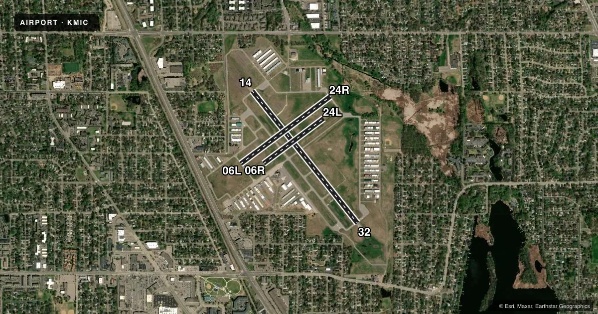
Runways & pattern
Full pagePattern entry · RWY 32
LEFT TRAFFIC| Runway | Heading (°M) | Length | Surface | Traffic |
|---|---|---|---|---|
| 14/32Favored | 139° / 319° | 3,751 ft | ASPH | Standard L |
| 06L/24R | 51° / 231° | 2,500 ft | ASPH | Standard L |
| 06R/24L | 51° / 231° | 1,669 ft | TURF | Standard L |
Runway end performance
| End | TORA | TODA | ASDA | LDA | VGSI | Approach lights | Obstruction |
|---|---|---|---|---|---|---|---|
| 14 | 3,509' | 3,509' | 3,750' | 3,508' | PAPI 4-box left(4°) | — | 57', tree, 1103' from thr, 2' R of cntrln, slope 15 |
| 32 | 3,508' | 3,508' | 3,750' | 3,509' | PAPI 4-box left(4°) | — | 48', trees, 944' from thr, 297' R of cntrln, slope 15 |
| 06L | 2,500' | 2,500' | 2,500' | 2,110' | VASI 4-box left(4°) | — | 67', tree, 1160' from thr, 198' R of cntrln, slope 14 |
| 24R | 2,500' | 2,500' | 2,500' | 2,111' | VASI 4-box left(3.5°) | — | 60', tree, 973' from thr, 2' R of cntrln, slope 12 |
Declared distances in feet. TORA = takeoff run available, TODA = takeoff distance, ASDA = accelerate-stop, LDA = landing distance.
Airport sketch
Runways drawn to scale from FAA survey coordinates, rendered over satellite imagery. Not for navigation.
Approaches & charts
Services on the field
Fuel grades, oxygen, maintenance, ramp storage and lighting — as declared to the FAA by the airport operator.
Fuel & services
- Fuel
- 100LLA
- Oxygen (bottled)
- Not available
- Oxygen (bulk)
- Not available
- Airframe repair
- Major
- Power plant repair
- Major
- Other services
- AMB,CHTR,INSTR,RNTL,SALES
Ramp & ground
- Transient storage
- Tie-down
- Hangar
- Landing fee
- No fee published
- Customs
- Not available
- Lighting schedule
- SEE RMK
- Beacon schedule
- SS-SR
- Beacon
- White / Green (civil land)(WG)
- Wind indicator
- Lighted
- Segmented circle
- No
Fuel & FBOs
Cheapest 100LL and Jet A on the field and nearby. Always confirm with the FBO before taxi.
Airport notes
Surface conditions, obstructions, local procedures, lighting outages and other notes published with each FAA cycle.
General notes
- BIRDS & WILDLIFE ON & INVOF ARPT.
- ULTRALIGHT OPS PROHIBITED.
- WHEN ATCT CLSD SNOW REMOVAL OPS MNT CTAF.
- HEL TRG CONDUCTED OVR GRASS EAST OF RWY 32 & SOUTH OF RWY 24L.
- TWY E BTN TWY G5 & G6 CLSD TO ACFT WITH WINGSPAN GTR THAN 55 FT.
- VOLUNTARY NOISE ABATEMENT PROCS IN EFCT. SEE ARPT WEBSITE FOR MORE INFO.
- WHEN ATCT CLSD, FOR CD CTC MINNEAPOLIS APCH ON 121.6.
Lighting notes
- WHEN ATCT CLSD ACTVT REIL RWY 14 & 32; MIRL RWY 14/32 & 06L/24R - CTAF. PAPI RWY 14 & 32; VASI RWY 06L & 24R - OPR CONSLY.
Fuel notes
- 100LLFUEL AVBL H24 VIA CREDIT CARD.
Runway surface & condition
- 06R/24LCLSD NOV-APR; CLSD WHEN ATCT CLSD.
Approach & departure obstructions
- 14CALM WIND RWY WHEN ATCT CLSD.
- 06RYELLOW CONES.
- 24LYELLOW CONES.
- 06L23:1 TO DTHR.
- 14CLNC SLP 23:1 TO DTHR.
- 24R21:1 TO DTHR.
- 32CLNC SLP 25:1 TO DTHR.
Other notes
- MANAGERSAM.SEAFELDT@MSPMAC.ORG
VFR map & nearby airports
VFR sectional. Tap any ICAO chip to open that airport.
Key facts · KMIC
Answer card- ICAO
- KMIC
- Name
- CRYSTAL
- Location
- MINNEAPOLIS, MINNESOTA
- Elevation
- 869.3 ft MSL
- Traffic pattern altitude
- 1,869.3 ft MSL (1,000 AGL)
- Control tower
- Towered · 0700-2100 OCT 1-APR 30; 0700-2200 MAY 1-SEP 30
- Total runways
- 3
- Longest runway
- 14/32 · 3,751 ft
- Published ILS approaches
- 0
- Published frequencies
- 9
- Magnetic variation
- 2°
- Current flight rules
- VFR
- Current wind
- 330° at 15 kt
- Favored runway now
- RWY 32
Crystal Airport sits in Minneapolis, Minnesota. Field elevation is 869.3 ft MSL. The airport has three runways. The longest is runway 14/32 at 3,751 ft. The field is towered. Tower hours are 0700-2100 OCT 1-APR 30. Hours extend to 0700-2200 MAY 1-SEP 30. No ILS approaches are published here, so plan with the current chart and the available non-precision options.
Pattern altitude is not published. Use 1,000 ft AGL for light piston operations unless local procedures or ATC say otherwise. The airport sits in the Minneapolis area, so expect busy traffic and coordinate carefully with tower and ground. Airspace class is not stated in the facts. Check the current sectional or TAC before you go.
No on-field FBOs are listed in the facts. 100LL is available 24 hours a day via credit card. Taxiway E is closed to aircraft with wingspan greater than 55 feet between taxiways G5 and G6. Yellow cones mark runways 06R and 24L. When the tower is closed, use CTAF to activate the runway end identifier lights on 14 and 32. Use CTAF to turn on the medium intensity runway lights for 14/32 and 06L/24R. The PAPI on 14 and 32 and the VASI on 06L and 24R stay on continuously.