METAR & TAF KMCI
Current METAR
Observed 21:53Z
KMCI 272153Z 22009KT 10SM SCT250 37/23 A2979 RMK AO2 SLP073 T03670233
- Wind
- 220° @ 9 kt
- Visibility
- 10 SM
- Temp / Dew
- 37°C / 23°C
- Altimeter
- 29.79 inHg
- Clouds
- SCT
- Density alt
- 4,075 ft
- Ceiling
- Unlimited
- Rules
- VFR
Airport info & contacts
Manager on record, flight service, ARTCC, attendance schedule and pattern altitude — published by the FAA and refreshed every 28 days.
Location
- From city
- 15 NM NW
- VFR sectional
- KANSAS CITY
- ARTCC
- ZKC · KANSAS CITY
- NOTAM facility
- MCI (NOTAM-D)
Airport manager
- Name
- MR. LUKE MAWHIRTER
- Phone
- 816-243-5248
- Address
- P.O. BOX 20047, KANSAS CITY MO 64195
Flight service · Hours
- FSS COU
- COLUMBIA1-800-WX-BRIEF
- Attendance
- ALL
Frequencies
Tap any row to copy the frequency to your clipboard.
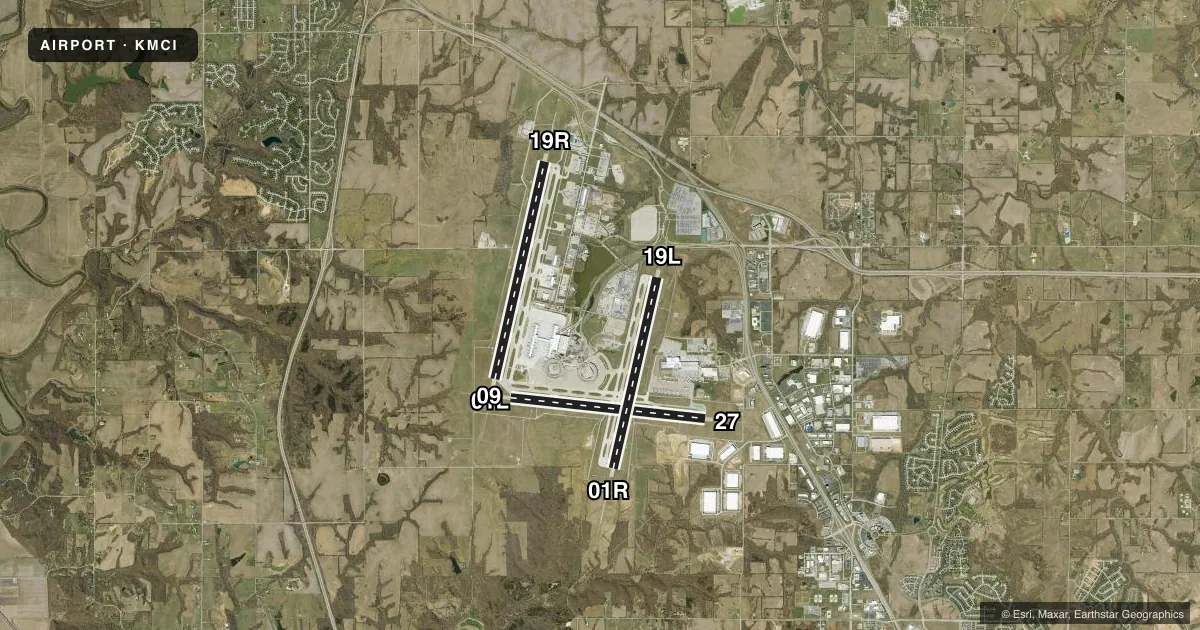
Runways & pattern
Full pagePattern entry · RWY 19R
RIGHT TRAFFIC| Runway | Heading (°M) | Length | Surface | Traffic |
|---|---|---|---|---|
| 01L/19RFavored | 11° / 191° | 10,801 ft | CONC | 19R R |
| 09/27 | 94° / 274° | 9,501 ft | ASPH | 27 R |
| 01R/19L | 11° / 191° | 9,500 ft | CONC | Standard L |
Runway end performance
| End | TORA | TODA | ASDA | LDA | VGSI | Approach lights | Obstruction |
|---|---|---|---|---|---|---|---|
| 01L | 10,801' | 10,801' | 10,801' | 10,801' | PAPI 4-box left(3°) | MALSR | — |
| 19R | 10,801' | 10,801' | 10,801' | 10,801' | PAPI 4-box right(3°) | ALSF2 | — |
| 09 | 9,501' | 9,501' | 9,501' | 9,501' | — | MALSR | — |
| 27 | 9,501' | 9,501' | 9,501' | 9,501' | PAPI 4-box left(3°) | MALSR | — |
| 01R | 9,500' | 9,500' | 9,500' | 9,500' | PAPI 4-box right(3°) | ALSF2 | — |
| 19L | 9,500' | 9,500' | 9,500' | 9,500' | — | MALSR | — |
Declared distances in feet. TORA = takeoff run available, TODA = takeoff distance, ASDA = accelerate-stop, LDA = landing distance.
Airport sketch
Runways drawn to scale from FAA survey coordinates, rendered over satellite imagery. Not for navigation.
Approaches & charts
ILS · 6
Services on the field
Fuel grades, oxygen, maintenance, ramp storage and lighting — as declared to the FAA by the airport operator.
Fuel & services
- Fuel
- 100LLA
- Oxygen (bottled)
- Not available
- Oxygen (bulk)
- Not available
- Airframe repair
- Not available
- Power plant repair
- Not available
- Other services
- CARGO
Ramp & ground
- Transient storage
- Tie-down
- Landing fee
- No fee published
- Customs
- Not available
- Beacon schedule
- SS-SR
- Beacon
- White / Green (civil land)(WG)
- Wind indicator
- Lighted
- Segmented circle
- No
Fuel & FBOs
Cheapest 100LL and Jet A on the field and nearby. Always confirm with the FBO before taxi.
Airport notes
Surface conditions, obstructions, local procedures, lighting outages and other notes published with each FAA cycle.
General notes
- WATERFOWL ON AND INVOF ARPT.
- WINDSHEAR ALERT SYSTEM ON ARPT.
- NOISE ABATEMENT PROCEDURES IN EFFECT 2200-0600 WITH LANDING ON RYS 01L & 19L; TAKEOFFS ON RYS 01R & 19R.
- MIL ACFT MAY BE CHARGED RAMP/PARKING FEES.
- PPR TO PARK AT TRML GATES CTC ARPT OPN 816-835-4315
- WHEN USING HIGH-SPEED EXITS C4 & C6 CONT TIL FIRST PARL TWY, THEN USE EXTREME CARE WHEN TURNING IN EXCESS OF 90 DEGREES.
- NO ACFT PARKING ON POSTAL APRON.
- DESIGN GROUP V AND VI ACFT RQR AN ARPT ESCORT ON TWY DELTA BTWN TWYS JULIET & C9.
- TWY B1 BTN TWY B AND FEDEX APN COCKPIT OVER CNTRLN STEERING RQRD
- TWY C2 BTN TWY C3 AND TWY C1 WINGSPAN RESTRICTION OF 118 FT.
- TXL W, N1, N3, M1, M3, S1, S3, D1, & D3 WINGSPAN RESTRICTION OF 118 FT.
- N RAMP CTL FREQ: 128.975
- S RAMP CTL FREQ: 130.825
- TWY B2 CLSD TO ACFT WINGSPAN MORE THAN 135FT.
Runway surface & condition
- 01L/19RPCR VALUE: 1106/R/D/W/T
- 01R/19LPCR VALUE: 1107/R/B/W/T
- 09/27PCR VALUE: 646/F/B/X/T
VFR map & nearby airports
VFR sectional. Tap any ICAO chip to open that airport.
Key facts · KMCI
Answer card- ICAO
- KMCI
- Name
- KANSAS CITY INTL
- Location
- KANSAS CITY, MISSOURI
- Elevation
- 1,026.9 ft MSL
- Traffic pattern altitude
- 2,026.9 ft MSL (1,000 AGL)
- Control tower
- Towered · 24
- Total runways
- 3
- Longest runway
- 01L/19R · 10,801 ft
- Published ILS approaches
- 6
- Published frequencies
- 25
- Magnetic variation
- 2°
- Current flight rules
- VFR
- Current wind
- 220° at 9 kt
- Favored runway now
- RWY 19R
Kansas City Intl sits in Kansas City, Missouri. The field elevation is 1,026.9 ft MSL. It has three runways. The longest is 10,801 ft on 01L/19R. The airport is towered. The tower is open 24 hours. Six ILS approaches are published here, which gives crews good instrument options on several runway ends.
For pattern work, the published pattern altitude is not listed. Use the standard 1,000 ft AGL for light piston traffic unless ATC gives you something different. That puts the pattern around 2,027 ft MSL based on the field elevation. Verify the current Chart Supplement before you fly. Signature Aviation is on the field. It carries 100LL and Jet A. Call them at (816) 243-6440 for current services.
This is a busy Class B airport with large-aircraft traffic and a lot of runway. Noise abatement is published for late night hours. Between 2200 and 0600, landings are on 01L and 19L. Takeoffs are on 01R and 19R. Taxiway and wingspan limits also matter here. Waterfowl are reported on and near the airport. Plan for bird activity on taxi. If you are flying a larger airframe, check the current Chart Supplement and coordinate closely with airport ops before arrival.