METAR & TAF KLNA
Current METAR
Observed 15:55Z
KLNA 271555Z AUTO 28006KT 10SM SCT030 33/22 A2996 RMK AO2 LTG DSNT SE T03260224
- Wind
- 280° @ 6 kt
- Visibility
- 10 SM
- Temp / Dew
- 33°C / 22°C
- Altimeter
- 29.96 inHg
- Clouds
- SCT
- Density alt
- 2,128 ft
- Ceiling
- Unlimited
- Rules
- VFR
Airport info & contacts
Manager on record, flight service, ARTCC, attendance schedule and pattern altitude — published by the FAA and refreshed every 28 days.
Location
- From city
- 6 NM S
- VFR sectional
- MIAMI
- ARTCC
- ZMA · MIAMI
- NOTAM facility
- MIA (NOTAM-D)
Airport manager
- Name
- LAURA BEEBE
- Phone
- 561-471-7405
- Address
- 846 PALM BEACH INTL AIRPORT, WEST PALM BEACH FL 33406-1470
Flight service · Hours
- FSS MIA
- MIAMI1-800-WX-BRIEF
- Attendance
- 0800-1830
Frequencies
Tap any row to copy the frequency to your clipboard.
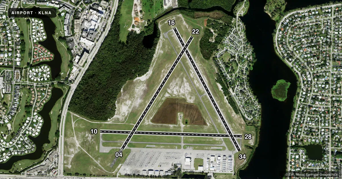
Runways & pattern
Full pagePattern entry · RWY 28
LEFT TRAFFIC| Runway | Heading (°M) | Length | Surface | Traffic |
|---|---|---|---|---|
| 10/28Favored | 85° / 265° | 3,489 ft | ASPH | Standard L |
| 16/34 | 145° / 325° | 3,421 ft | ASPH | Standard L |
| 04/22 | 25° / 205° | 3,256 ft | ASPH | Standard L |
Runway end performance
| End | TORA | TODA | ASDA | LDA | VGSI | Approach lights | Obstruction |
|---|---|---|---|---|---|---|---|
| 10 | — | — | — | — | PAPI 2-box left(4°) | — | 42', trees, 1045' from thr, 125' R of cntrln, slope 20 |
| 28 | — | — | — | — | PAPI 2-box left(4°) | — | 56', trees, 1332' from thr, 175' R of cntrln, slope 20 |
| 16 | — | — | — | — | PAPI 2-box left(3.5°) | — | 17', trees, 600' from thr, 30' R of cntrln, slope 23 |
| 34 | — | — | — | — | PAPI 2-box left(3.5°) | — | 5', brush, 200' from thr, 150' R of cntrln, slope 1 |
| 04 | — | — | — | — | PAPI 2-box left(3°) | — | 37', tree, 970' from thr, 0' R of cntrln, slope 21 |
| 22 | — | — | — | — | PAPI 2-box left(3°) | — | 16', brush, 525' from thr, 70' R of cntrln, slope 21 |
Declared distances in feet. TORA = takeoff run available, TODA = takeoff distance, ASDA = accelerate-stop, LDA = landing distance.
Airport sketch
Runways drawn to scale from FAA survey coordinates, rendered over satellite imagery. Not for navigation.
Approaches & charts
Services on the field
Fuel grades, oxygen, maintenance, ramp storage and lighting — as declared to the FAA by the airport operator.
Fuel & services
- Fuel
- 100LLA
- Oxygen (bottled)
- Not available
- Oxygen (bulk)
- Not available
- Airframe repair
- Major
- Power plant repair
- Major
- Other services
- AVNCS,CHTR,INSTR,RNTL
Ramp & ground
- Transient storage
- Tie-down
- Hangar
- Landing fee
- No fee published
- Customs
- Not available
- Lighting schedule
- SEE RMK
- Beacon schedule
- SS-SR
- Beacon
- White / Green (civil land)(WG)
- Wind indicator
- Lighted
Fuel & FBOs
Cheapest 100LL and Jet A on the field and nearby. Always confirm with the FBO before taxi.
Airport notes
Surface conditions, obstructions, local procedures, lighting outages and other notes published with each FAA cycle.
General notes
- LNA IS A NOISE-SENSITIVE ARPT; USE OF THE PREF NOISE ABATEMENT RWY, RWY 4-22, CONDS PMTG, IS STGLY ENCOURAGED. CALL (561)471-7468
- NO TGLS ON RY 10/28.
- HELICOPTERS USE RIGHT TRAFFIC TO ALL RYS.
- EXTENSIVE FLIGHT TRAINING, MULTIPLE RUNWAYS IN USE.
- NONSTANDARD HOLD SHORT MARKINGS ON TWY P BTN RWYS 10/28 AND 16/34.
- AIRPORT SURFACE CONDITIONS NOT REPORTED FOR ALL RUNWAYS.
- FOR CD CTC PALM BEACH APCH AT 561-684-9047.
- RWY 34 APCH END HAS 25 FT BLDG 50 FT FM RWY END 225 FT LEFT OF EXTDD CTLN.
- 24-HR PPR RQ FOR ALL ACFT EQUIPPED WITH WX MODIFICATION EQPT OR ACFT CPBL OF WX MODIFICATION AND/OR GEOENGINEERING BY CTC THE DEPT OF ARPT COMMUNICATIONS CNTR AT (561) 471-7420.
Lighting notes
- DUSK-2000. AFTER 2000, ACTVT MIRL RWYS 04/22, 10/28 & 16/34 - CTAF. PAPI RWY 10, 16, 28, & 34 OPR CONSLY.
Approach & departure obstructions
- 34RWY 34 HAS 2 FT BRUSH 200 FT FM RWY END 150 FT RIGHT.
Other notes
- STANDARD PATTERN ENTRY TO ALL RUNWAYS STRONGLY RECOMMENDED.
VFR map & nearby airports
VFR sectional. Tap any ICAO chip to open that airport.
Key facts · KLNA
Answer card- ICAO
- KLNA
- Name
- PALM BEACH COUNTY PARK
- Location
- WEST PALM BEACH, FLORIDA
- Elevation
- 14.4 ft MSL
- Traffic pattern altitude
- 1,014.4 ft MSL (1,000 AGL)
- Control tower
- Non-towered (use CTAF)
- Total runways
- 3
- Longest runway
- 10/28 · 3,489 ft
- Published ILS approaches
- 0
- Published frequencies
- 5
- Magnetic variation
- 7°
- Current flight rules
- VFR
- Current wind
- 280° at 6 kt
- Favored runway now
- RWY 28
Palm Beach County Park is in West Palm Beach, Florida. Field elevation is 14.4 ft MSL. The airport has three asphalt runways. The longest is 3,489 ft on 10/28. There is no control tower. No ILS approaches are published. Pattern altitude is not published, so plan on the standard 1,000 ft AGL for light piston traffic unless current instructions say otherwise.
Stellar Aviation of South Palm Beach is on the field. It carries 100LL, Jet A and Jet A Prist. Use the FBO directly by phone for current service details before arrival. The field is noise-sensitive. Runway 04/22 is the preferred noise abatement runway when conditions allow. No touch-and-go landings are allowed on runway 10/28. Standard pattern entry to all runways is strongly recommended.
This is an active training airport with multiple runways in use. Helicopters use right traffic to all runways. Runway 34 has a building near the departure end, so give that end extra attention on takeoff and landing. After 2000 local, runway lights are activated via CTAF. PAPI is continuous on 10, 16, 28 and 34. For clearance delivery, Palm Beach Approach handles it. Check the current FAA Chart Supplement for any changes before you go.