METAR & TAF KISM
Current METAR
Observed 12:56Z
KISM 271256Z 30009KT 10SM FEW100 26/24 A2994 RMK AO2 SLP141 T02610239 $
- Wind
- 300° @ 9 kt
- Visibility
- 10 SM
- Temp / Dew
- 26°C / 24°C
- Altimeter
- 29.94 inHg
- Clouds
- FEW
- Density alt
- 1,397 ft
- Ceiling
- Unlimited
- Rules
- VFR
Airport info & contacts
Manager on record, flight service, ARTCC, attendance schedule and pattern altitude — published by the FAA and refreshed every 28 days.
Location
- From city
- 16 NM SW
- VFR sectional
- JACKSONVILLE
- ARTCC
- ZJX · JACKSONVILLE
- NOTAM facility
- ISM (NOTAM-D)
Airport manager
- Name
- SHAUN GERMOLUS
- Phone
- 407-518-2516
- Address
- KISSIMMEE GATEWAY AIRPORT, 401 DYER BOULEVARD, KISSIMMEE FL 34741-4613
Flight service · Hours
- FSS PIE
- SAINT PETERSBURG1-800-WX-BRIEF
- Attendance
- 0700-2200
Frequencies
Tap any row to copy the frequency to your clipboard.
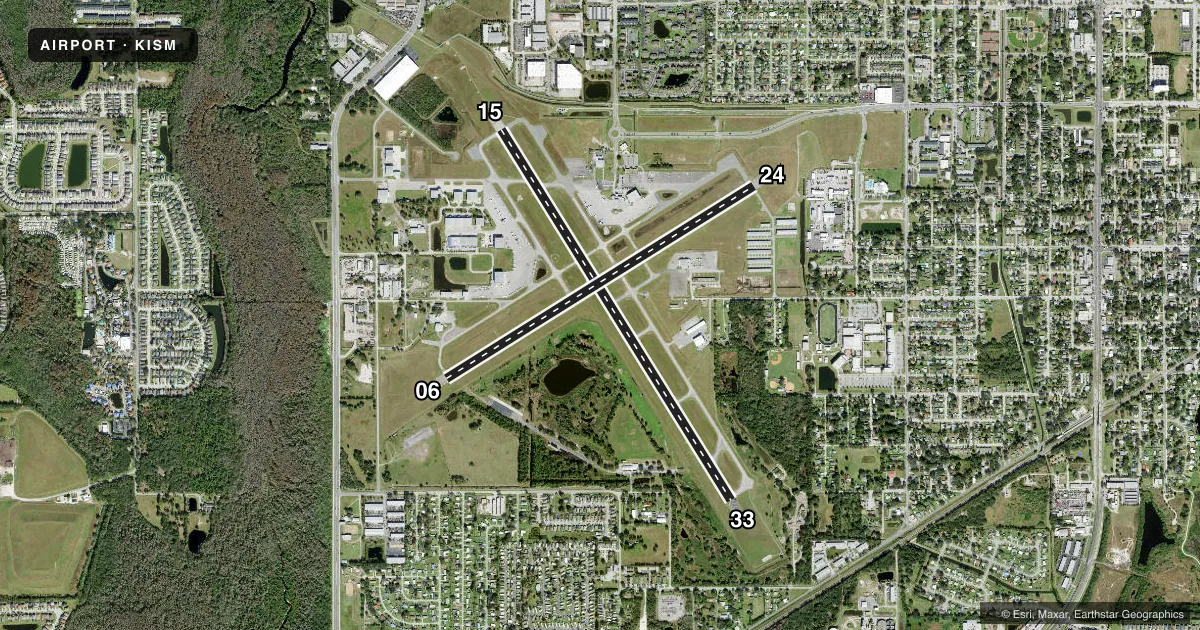
Runways & pattern
Full pagePattern entry · RWY 33
LEFT TRAFFIC| Runway | Heading (°M) | Length | Surface | Traffic |
|---|---|---|---|---|
| 15/33Favored | 143° / 323° | 6,001 ft | ASPH | 15 R |
| 06/24 | 53° / 233° | 5,001 ft | ASPH | 06 R |
Runway end performance
| End | TORA | TODA | ASDA | LDA | VGSI | Approach lights | Obstruction |
|---|---|---|---|---|---|---|---|
| 15 | — | — | — | — | PAPI 4-box left(3°) | MALSF | 25', tree, 1332' from thr, 260' R of cntrln, slope 45 |
| 33 | — | — | — | — | PAPI 4-box left(3°) | — | 6', fence, 200' from thr, 245' R of cntrln, slope 0 |
| 06 | — | — | — | — | PAPI 4-box left(3°) | — | 33', trees, 1170' from thr, 280' R of cntrln, slope 29 |
| 24 | — | — | — | — | PAPI 4-box left(3°) | — | 41', pole, 1585' from thr, 175' R of cntrln, slope 34 |
Declared distances in feet. TORA = takeoff run available, TODA = takeoff distance, ASDA = accelerate-stop, LDA = landing distance.
Airport sketch
Runways drawn to scale from FAA survey coordinates, rendered over satellite imagery. Not for navigation.
Approaches & charts
ILS · 1
Services on the field
Fuel grades, oxygen, maintenance, ramp storage and lighting — as declared to the FAA by the airport operator.
Fuel & services
- Fuel
- 100LLA
- Oxygen (bottled)
- Not available
- Oxygen (bulk)
- High pressure
- Airframe repair
- Major
- Power plant repair
- Major
- Other services
- AFRT,AMB,AVNCS,CARGO,CHTR,INSTR,RNTL,SALES,SURV
Ramp & ground
- Transient storage
- Tie-down
- Hangar
- Landing fee
- Yes
- Customs
- Not available
- Lighting schedule
- SEE RMK
- Beacon schedule
- SS-SR
- Beacon
- White / Green (civil land)(WG)
- Wind indicator
- Lighted
Fuel & FBOs
Cheapest 100LL and Jet A on the field and nearby. Always confirm with the FBO before taxi.
Airport notes
Surface conditions, obstructions, local procedures, lighting outages and other notes published with each FAA cycle.
General notes
- NOISE SENSITIVE AREA 1/2 MI N OF AER 24. DEP RWY 06 EARLY TURNOUTS NA.
- REQ ALL JETS/TURBO PROPS USE NBAA CLOSE-IN PROC.
- ULTRALGT ACFT NA EXCEPT PPR - AMGR.
- LOW LVL VFR HEL, WILDLIFE & BIRDS ON & INVOF ARPT.
- HEL RUN ON LNDG NA.
- RWY 15 HAS UNLGTED OBSTNS PRESENT IN THE APCH DUE TO 52 FT TREES 1960 FT BFR AER.
- LNDG FEE: CTC ARPT OR CK ARPT WEBSITE FOR DTLS, EXEMPTIONS.
Lighting notes
- WHEN ATCT CLSD ACTVT MALSF RWY 15; REIL RWY 06 & 24 & 33; PAPI RWY 06, 15, 24, & 33; MIRL RWY 06/24 & 15/33 - CTAF.
Approach & departure obstructions
- 33+6 FT FENCE 190 FT FM RWY END 245 FT R OF CNTRLN.
- 06HOLDING BAY RSTRD TO ACFT WITH WINGSPAN OF 49 FT OR LESS.
- 15CALM WIND RWY.
- 33MULT UNLGT OBSTNS FIRST 3000 FT; 250-500 FT E & W OF CNTRLN.
VFR map & nearby airports
VFR sectional. Tap any ICAO chip to open that airport.
Key facts · KISM
Answer card- ICAO
- KISM
- Name
- KISSIMMEE GATEWAY
- Location
- ORLANDO, FLORIDA
- Elevation
- 82.1 ft MSL
- Traffic pattern altitude
- 1,082.1 ft MSL (1,000 AGL)
- Control tower
- Towered · 0700-2200
- Total runways
- 2
- Longest runway
- 15/33 · 6,001 ft
- Published ILS approaches
- 1
- Published frequencies
- 9
- Magnetic variation
- 5°
- Current flight rules
- VFR
- Current wind
- 300° at 9 kt
- Favored runway now
- RWY 33
Kissimmee Gateway sits in Orlando, Florida. Field elevation is 82.1 ft MSL. The airport has two asphalt runways. The longest is 15/33 at 6,001 ft. Runway 06/24 is 5,001 ft. The tower is open daily from 0700 to 2200. One ILS approach is published for runway 15. Pattern altitude is not published, so use the standard 1,000 ft AGL for light piston traffic unless the current Chart Supplement says otherwise.
Signature Aviation is on the field. It carries 100LL and Jet A. Velocity Aviation, formerly Odyssey Aviation, is also on the field. It carries 100LL, Jet A and Jet A Prist. For runway work, note that runway 15 is the calm wind runway. The airport also has a noise sensitive area north of the field. Early turnouts after departure from runway 06 are not authorized. Jets and turboprops must use the NBAA close-in procedure. If you are coming in at night or after tower hours, check the lighting setup before arrival. The field uses CTAF for light activation when the tower is closed.
This is busy central Florida airspace. Plan for traffic. Keep an eye out for helicopters, wildlife and birds in the area. Review the current Chart Supplement before departure for any published operational details that matter to your flight.