METAR & TAF KHPN
Current METAR
Observed 12:56Z
KHPN 271256Z AUTO 00000KT 10SM CLR 22/18 A2984 RMK AO2 SLP101 T02220178
- Wind
- 000° @ 0 kt
- Visibility
- 10 SM
- Temp / Dew
- 22°C / 18°C
- Altimeter
- 29.84 inHg
- Clouds
- CLR
- Density alt
- 1,484 ft
- Ceiling
- Unlimited
- Rules
- VFR
Airport info & contacts
Manager on record, flight service, ARTCC, attendance schedule and pattern altitude — published by the FAA and refreshed every 28 days.
Location
- From city
- 3 NM NE
- VFR sectional
- NEW YORK
- ARTCC
- ZNY · NEW YORK
- NOTAM facility
- HPN (NOTAM-D)
Airport manager
- Name
- APRIL GASPARRI
- Phone
- 914-995-4887
- Address
- 240 AIRPORT ROAD SUITE 202, WHITE PLAINS NY 10604
Flight service · Hours
- FSS ISP
- NEW YORK1-800-WX-BRIEF
- Attendance
- ALL
Frequencies
Tap any row to copy the frequency to your clipboard.
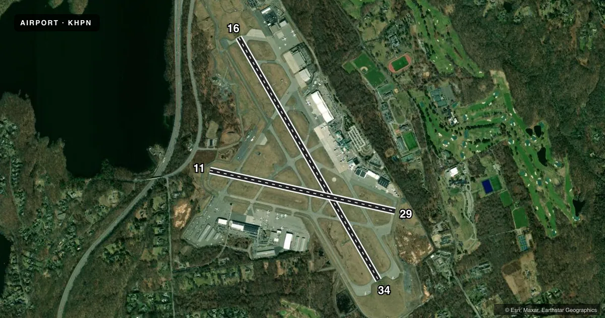
Runways & pattern
Full pagePattern entry · RWY 16
LEFT TRAFFIC| Runway | Heading (°M) | Length | Surface | Traffic |
|---|---|---|---|---|
| 16/34 | 137° / 317° | 6,549 ft | ASPH | Standard L |
| 11/29 | 89° / 269° | 4,451 ft | ASPH | Standard L |
Runway end performance
| End | TORA | TODA | ASDA | LDA | VGSI | Approach lights | Obstruction |
|---|---|---|---|---|---|---|---|
| 16 | 6,549' | 6,549' | 6,549' | 6,549' | PAPI 4-box left(3°) | MALSR | — |
| 34 | 6,549' | 6,549' | 6,549' | 6,549' | PAPI 4-box left(3°) | — | 87', bldg, 3460' from thr, 600' R of cntrln, slope 37 |
| 11 | 4,451' | 4,451' | 4,451' | 4,451' | PAPI 4-box left(3°) | — | — |
| 29 | 4,451' | 4,451' | 4,451' | 3,159' | — | — | 71', trees, 527' from thr, 15' R of cntrln, slope 4 |
Declared distances in feet. TORA = takeoff run available, TODA = takeoff distance, ASDA = accelerate-stop, LDA = landing distance.
Airport sketch
Runways drawn to scale from FAA survey coordinates, rendered over satellite imagery. Not for navigation.
Approaches & charts
ILS · 2
Services on the field
Fuel grades, oxygen, maintenance, ramp storage and lighting — as declared to the FAA by the airport operator.
Fuel & services
- Fuel
- 100LLA
- Oxygen (bottled)
- HIGH/LOW
- Oxygen (bulk)
- HIGH/LOW
- Airframe repair
- Major
- Power plant repair
- Major
- Other services
- AVNCS,CARGO,CHTR,INSTR,RNTL,SALES
Ramp & ground
- Transient storage
- Tie-down
- Hangar
- Landing fee
- Yes
- Customs
- Not available
- Lighting schedule
- SEE RMK
- Beacon schedule
- SS-SR
- Beacon
- White / Green (civil land)(WG)
- Wind indicator
- Lighted
- Segmented circle
- No
Fuel & FBOs
Cheapest 100LL and Jet A on the field and nearby. Always confirm with the FBO before taxi.
Airport notes
Surface conditions, obstructions, local procedures, lighting outages and other notes published with each FAA cycle.
General notes
- NOISE ABATEMENT PROC IN EFCT CTC ARPT MGMT 914-995-4861.
- BIRDS & OTHER WILDLIFE ON & INVOF ARPT.
- ACFT OPRG WITH MGTOW OVR 120000 LBS MUST HAVE PRIOR PERMISSION. CTC ARPT OPNS FOR PPR LINK, CALL 914-995-4850. ALL APVD ACFT MUST CTC ARPT OPNS ON UNICOM WITH ACTUAL TKOF & LDG WTS.
- EQUIP AND MTRLS STAGED ADJ TO SOUTHERN EDGE OF HNGR 6 RAMP.
- FOUR DSGND HEL RTES IN USE FOR NOISE ABATEMENT.
- ATC CLNC RQRD FOR PUSHBACK ONTO MOV AREAS.
- MOWING WITHIN SAFETY AREAS OF ALL RWYS AND TWYS MAY THRU NOV.
- SN REMOVAL EQUIP OPRG ON ALL ACFT MOV AREAS NOV THRU APR.
- RWY 29 CLSD TO LDG ACFT MORE THAN 12500 LBS.
- HNGR D3 RAMP ADJ TO ACTV PAX LOADING AREA AT MAIN TRML RAMP, ACFT REQSTD USE MNM THRUST AND AVOID EXCESS PWR AND JET BLAST.
- FOR CD WHEN ATCT CLSD CTC NEW YORK APCH ON 126.4, IF UNA CALL 516-683-2849.
- RWY 11/29 DLY CLOSURES FOR STAGING AND/OR PRKG OF SKED ACR.
- LIGHTER THAN AIR AIRCRAFT RSTRD FM OPNS AT ARPT.
- FAR 139 ARFF INDEX C IS RSTRD TO MAX. ACFT LEN OF 130 FT WHEN OPERG AT MAIN TERMINAL, GATES 1 THRU 6.
Lighting notes
- WHEN ATCT CLSD ACTVT MALSR RWY 16; REIL RWY 11 & 34; TDZ LGTS RWY 16; CNTRLN LGTS RWY 16/34; HIRL RWY 16/34; MIRL RWY 11/29; TWY LGTS - CTAF.
Runway surface & condition
- 16/34PCR VALUE: 537/F/B/W/T
- 11/29RWY 11/29 NOT AVBL FOR PART 121/PART 380 OPS WITH SKED PAX CARRYING OPS MORE THAN 9 PAX SEATS AND NON-SKED PAX CARRYING OPS MORE THAN 30 PAX SEATS. NO PART 121/PART 380 OPS EXC FOR TAX.
Approach & departure obstructions
- 11RWY 11 AIMING POINT MARKINGS.
- 29APCH RATIO 25:1 TO DSPLCD THR.
VFR map & nearby airports
VFR sectional. Tap any ICAO chip to open that airport.
Key facts · KHPN
Answer card- ICAO
- KHPN
- Name
- WESTCHESTER COUNTY
- Location
- WHITE PLAINS, NEW YORK
- Elevation
- 439 ft MSL
- Traffic pattern altitude
- 1,439 ft MSL (1,000 AGL)
- Control tower
- Towered · 0600-2300
- Total runways
- 2
- Longest runway
- 16/34 · 6,549 ft
- Published ILS approaches
- 2
- Published frequencies
- 16
- Magnetic variation
- 13°
- Current flight rules
- VFR
- Current wind
- 000° at 0 kt
- Favored runway now
- –
Westchester County Airport sits in White Plains, New York. Field elevation is 439 ft MSL. It has two asphalt runways. The longest is runway 16/34 at 6,549 ft. Runway 11/29 is 4,451 ft. The tower is open daily from 0600 to 2300. Two ILS approaches are published for runway ends 16 and 34.
Pattern altitude is not published in the facts. Use the standard 1,000 ft AGL for light piston traffic unless ATC or the current FAA Chart Supplement says otherwise. Noise abatement procedures are in effect. Contact airport management before you go if you need the current guidance. Wildlife is also a factor here. Expect birds on or near the field.
On the field, Atlantic Aviation West, Atlantic Aviation East, Signature Aviation East, Signature Aviation West and Million Air are available. They carry 100LL and Jet A. Million Air also carries Jet A Prist. If you are arriving at night or after tower hours, note that runway 16 lighting is the main published setup. Centerline and high intensity lights are on 16/34. Runway 29 is closed to landing aircraft over 12,500 pounds. Heavy aircraft over 120,000 pounds need prior permission from airport operations.