METAR & TAF KHNB
Current METAR
Observed 12:56Z
KHNB 271256Z AUTO 17003KT 10SM CLR 23/23 A2992 RMK AO2 SLP127 T02330228
- Wind
- 170° @ 3 kt
- Visibility
- 10 SM
- Temp / Dew
- 23°C / 23°C
- Altimeter
- 29.92 inHg
- Clouds
- CLR
- Density alt
- 1,616 ft
- Ceiling
- Unlimited
- Rules
- VFR
Airport info & contacts
Manager on record, flight service, ARTCC, attendance schedule and pattern altitude — published by the FAA and refreshed every 28 days.
Location
- From city
- 3 NM S
- VFR sectional
- ST LOUIS
- ARTCC
- ZID · INDIANAPOLIS
- NOTAM facility
- HNB (NOTAM-D)
Airport manager
- Name
- TRAVIS MCQUEEN
- Phone
- 812-683-5454
- Address
- 2495 WEST 900 SOUTH, PO BOX 293, HUNTINGBURG IN 47542
Flight service · Hours
- FSS HUF
- TERRE HAUTE1-800-WX-BRIEF
- Attendance
- MON-FRI · 0700-1600
Frequencies
Tap any row to copy the frequency to your clipboard.
Runways & pattern
Full pagePattern entry · RWY 09
LEFT TRAFFICRunway end performance
| End | TORA | TODA | ASDA | LDA | VGSI | Approach lights | Obstruction |
|---|---|---|---|---|---|---|---|
| 09 | — | — | — | — | PAPI 4-box left(3°) | — | 6', road, 390' from thr, 280' R of cntrln, slope 31 |
| 27 | — | — | — | — | PAPI 4-box left(3°) | — | — |
Declared distances in feet. TORA = takeoff run available, TODA = takeoff distance, ASDA = accelerate-stop, LDA = landing distance.
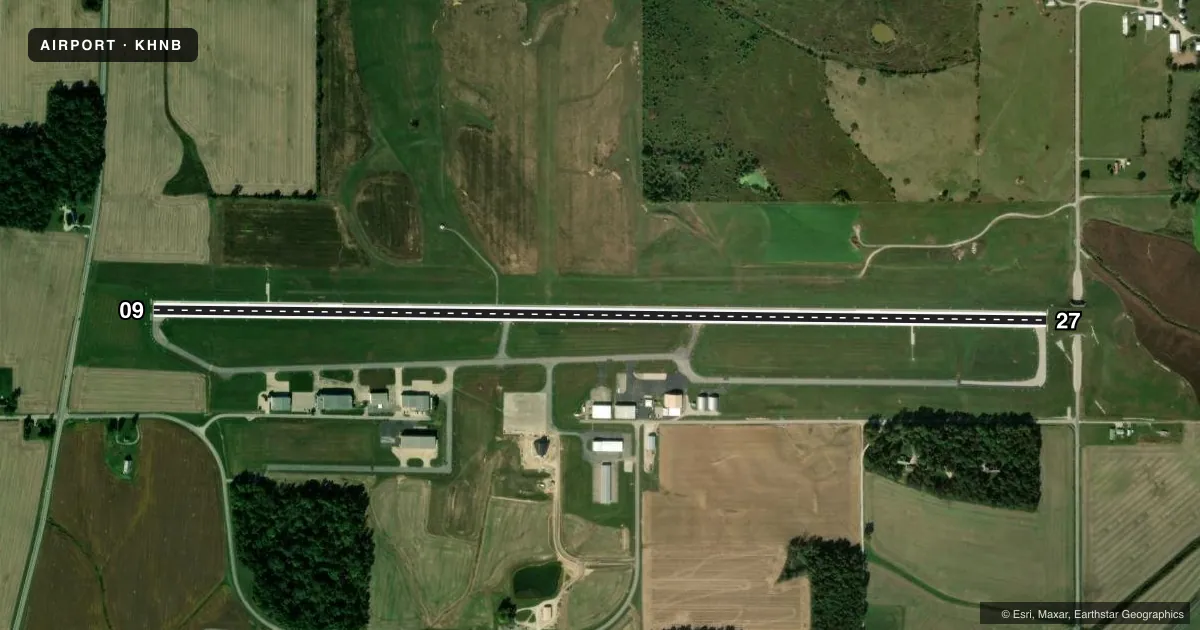
Airport sketch
Runways drawn to scale from FAA survey coordinates, rendered over satellite imagery. Not for navigation.
Approaches & charts
Services on the field
Fuel grades, oxygen, maintenance, ramp storage and lighting — as declared to the FAA by the airport operator.
Fuel & services
- Fuel
- 100LLA1+
- Airframe repair
- Minor
- Power plant repair
- Minor
- Other services
- AGRI,INSTR,RNTL
Ramp & ground
- Transient storage
- Tie-down
- Hangar
- Landing fee
- No fee published
- Customs
- Not available
- Lighting schedule
- SEE RMK
- Beacon schedule
- SEE RMK
- Beacon
- White / Green (civil land)(WG)
- Wind indicator
- Lighted
- Segmented circle
- No
Fuel & FBOs
Cheapest 100LL and Jet A on the field and nearby. Always confirm with the FBO before taxi.
Airport notes
Surface conditions, obstructions, local procedures, lighting outages and other notes published with each FAA cycle.
General notes
- TWY EDGE MRKD BY BLUE REFLECTORS.
- FOR CD WHEN RCO 118.8 OTS CTC EVANSVILLE APCH AT 812-436-4689, WHEN APCH CLSD CTC INDIANAPOLIS ARTCC AT 317-247-2411.
- SELF SVC FUEL AVBL WITH CREDIT CARD.
Lighting notes
- SS-SR; ACTVT ROTG BCN SR-SS CTAF.
- ACTVT REIL RWY 09 & 27; PAPI RWY 09 & 27; MIRL RWY 09/27 - CTAF.
Approach & departure obstructions
- 09PAPI UNUSBL BYD 5 DEG LEFT OF CNTRLN.
Other notes
- 1AFT HR & WKEND PPR - AMGR.
VFR map & nearby airports
VFR sectional. Tap any ICAO chip to open that airport.
Key facts · KHNB
Answer card- ICAO
- KHNB
- Name
- HUNTINGBURG
- Location
- HUNTINGBURG, INDIANA
- Elevation
- 529.1 ft MSL
- Traffic pattern altitude
- 1,529.1 ft MSL (1,000 AGL)
- Control tower
- Non-towered (use CTAF)
- Total runways
- 1
- Longest runway
- 09/27 · 5,501 ft
- Published ILS approaches
- 0
- Published frequencies
- 5
- Magnetic variation
- 4°
- Current flight rules
- VFR
- Current wind
- 170° at 3 kt
- Favored runway now
- RWY 09
KHNB is in Huntingburg, Indiana. The field elevation is 529.1 ft MSL. It has one runway. Runway 09/27 is 5,501 ft long and is the longest runway on the field. There is no control tower. The airport uses CTAF 122.8 for local traffic. No ILS approaches are published here.
Pattern altitude is not published. Use the standard 1,000 ft AGL pattern for light piston traffic unless the current Chart Supplement or the airport operator says otherwise. Runway 09 and 27 have runway end identifier lights. Medium intensity runway lights are available on 09/27 and are controlled by CTAF. PAPI is available on both ends. The PAPI on runway 09 is unusable beyond 5 degrees left of centerline.
Dubois County Airport Authority is on the field. It carries 100LL and Jet A. Self-service fuel is available with credit card. After hours and on weekends, prior permission is required from the airport manager. Taxiway edges are marked by blue reflectors. For clearance delivery, the remote communications outlet is on 118.8. If that outlet is out of service, contact Evansville Approach. If approach is closed, contact Indianapolis ARTCC.