METAR & TAF KEDC
Current METAR
Observed 13:35Z
KEDC 271335Z AUTO 20005KT 10SM SCT012 26/23 A3001 RMK AO2 T02650235 $
- Wind
- 200° @ 5 kt
- Visibility
- 10 SM
- Temp / Dew
- 26°C / 23°C
- Altimeter
- 30.01 inHg
- Clouds
- SCT
- Density alt
- 1,977 ft
- Ceiling
- Unlimited
- Rules
- VFR
Airport info & contacts
Manager on record, flight service, ARTCC, attendance schedule and pattern altitude — published by the FAA and refreshed every 28 days.
Location
- From city
- 12 NM NE
- VFR sectional
- SAN ANTONIO
- ARTCC
- ZHU · HOUSTON
- NOTAM facility
- EDC (NOTAM-D)
Airport manager
- Name
- REED BRICKEY
- Phone
- 713-679-4308
- Address
- 6012 AVIATION DR, PFLUGERVILLE TX 78660
Flight service · Hours
- FSS SJT
- SAN ANGELO1-800-WX-BRIEF
- Attendance
- ALL
Frequencies
Tap any row to copy the frequency to your clipboard.
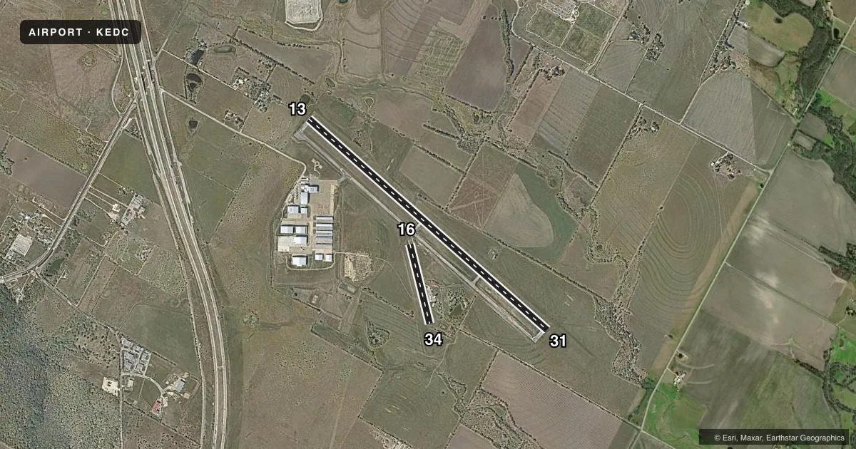
Runways & pattern
Full pagePattern entry · RWY 16
LEFT TRAFFIC| Runway | Heading (°M) | Length | Surface | Traffic |
|---|---|---|---|---|
| 13/31 | 127° / 307° | 6,025 ft | ASPH | Standard L |
| 16/34Favored | 161° / 341° | 1,550 ft | ASPH | Standard L |
Runway end performance
| End | TORA | TODA | ASDA | LDA | VGSI | Approach lights | Obstruction |
|---|---|---|---|---|---|---|---|
| 13 | — | — | — | — | PAPI 4-box left(3°) | — | 58', tree, 900' from thr, 400' R of cntrln, slope 12 |
| 31 | — | — | — | — | PAPI 4-box left(3°) | — | — |
Declared distances in feet. TORA = takeoff run available, TODA = takeoff distance, ASDA = accelerate-stop, LDA = landing distance.
Airport sketch
Runways drawn to scale from FAA survey coordinates, rendered over satellite imagery. Not for navigation.
Approaches & charts
Services on the field
Fuel grades, oxygen, maintenance, ramp storage and lighting — as declared to the FAA by the airport operator.
Fuel & services
- Fuel
- 100LLA+
- Airframe repair
- Major
- Power plant repair
- Major
- Other services
- CHTR,INSTR
Ramp & ground
- Transient storage
- Tie-down
- Hangar
- Landing fee
- No fee published
- Lighting schedule
- SEE RMK
- Beacon schedule
- SS-SR
- Beacon
- White / Green (civil land)(WG)
- Wind indicator
- Lighted
- Segmented circle
- Yes
Fuel & FBOs
Cheapest 100LL and Jet A on the field and nearby. Always confirm with the FBO before taxi.
Airport notes
Surface conditions, obstructions, local procedures, lighting outages and other notes published with each FAA cycle.
General notes
- VFR DEPS REQUESTING ATC SVC REMAIN CLEAR OF THE FINAL APCH CRS OF KAUS RWYS 18L & 18R. IF THE ACFT IS INITIALLY EASTBOUND, CTC AUS APCH CTL ON 127.22. IF THE ACFT IS INITIALLY WESTBOUND CTC AUS APCH CTL ON 125.32. AUS CLEAREANCE DELIVERY 126.025.
- RWY 13/31 TWY EDGES ARE MKD BY REFLECTOR POSTS.
- NW END OF RWY 13/31 & TWY A HAS A 16 FT DROP OFF AT END OF PAVEMENT.
- FOR CD CTC AUSTIN APCH AT 512-369-7865.
Lighting notes
- ACTVT REIL RWYS 13 & 31; MIRL RWY 13/31 - CTAF.
Runway surface & condition
- 16/34CLSD INDEFLY.
Approach & departure obstructions
- 3410 TREE, 100 FT DSTC, 50 FT R.
- 13APCH SLOPE 23:1 TO DSPLCD THR.
Other notes
- MANAGERRBRICKEY@AUSTINEXECUTIVEAIRPORT.COM
- 16/34EXTSV CRACKING, VEGETATION GROWING THROUGH.
VFR map & nearby airports
VFR sectional. Tap any ICAO chip to open that airport.
Key facts · KEDC
Answer card- ICAO
- KEDC
- Name
- AUSTIN EXEC
- Location
- AUSTIN, TEXAS
- Elevation
- 620 ft MSL
- Traffic pattern altitude
- 1,620 ft MSL (1,000 AGL)
- Control tower
- Towered · 0700-2200
- Total runways
- 2
- Longest runway
- 13/31 · 6,025 ft
- Published ILS approaches
- 0
- Published frequencies
- 7
- Magnetic variation
- 5°
- Current flight rules
- VFR
- Current wind
- 200° at 5 kt
- Favored runway now
- RWY 16
Austin Exec is in Austin, Texas. The field elevation is 620 ft MSL. It has two asphalt runways. The longest is runway 13/31 at 6,025 ft. Runway 16/34 is 1,550 ft and is closed indefinitely, so plan around 13/31 for current operations.
The airport has a control tower. Tower hours are 0700-2200. No ILS approaches are published here. Pattern altitude is not published, so use the standard 1,000 ft AGL for light piston operations unless ATC or the current FAA Chart Supplement says otherwise. Henriksen Jet Center is on the field. It carries AVGAS 100LL and Jet A Prist. For current service details, call the FBO directly.
A few remarks matter here. The northwest end of runway 13/31 and taxiway A have a 16 ft drop off at the pavement edge. Runway 13 has a displaced threshold with a 23 to 1 approach slope. Runway 16/34 has cracking, vegetation through the pavement and a tree near the runway 34 end. VFR departures that want ATC service should stay clear of the final approach course for KAUS runways 18L and 18R. If you are going eastbound, contact Austin Approach on 127.225. If you are going westbound, use 317.65. This is busy Austin airspace. Brief the departure and arrival carefully before you go.